
| ST CHARLES COUNTY SMARTT ST CHARLES MO |
| |
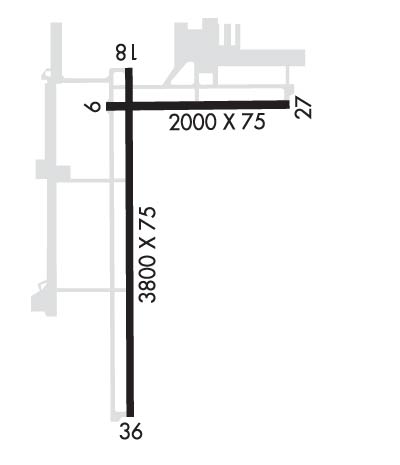
| Lat: N 3855.8 Long: W 09025.8 Elev: 437 Var: -01 Longest Runway: 3800 | ||
| Clr Del: 121.6 AWOS: 118.07 CTAF: 122.7 | ||
| ||||||||||||||||||||||||||||||||
| ||||||||||||||||||||||||||||||||
| ||||||||||||||||||||||||||||||||
| ||||||||||||||||||||||||||||||||
| ||||||||||||||||||||||||||||||||
| ||||||||||||||||||||||||||||||||
| Rwy | Rwy | |||||||
| 2000x75 | 2000' | 2000x75 | 2000' | |||||
| 3800x75 | 3800' | 3800x75 | 3800' | |||||
| Runway ID | Single Wheel | Double Wheel | Double Tandem Wheel | Dual Double Wheel |
| 09/27 | 12,500 | N/A | N/A | N/A |
| 18/36 | 12,500 | N/A | N/A | N/A |
| These numbers are Advisory and are not limits. The Airport Manager should have more accurate Weight Limits | ||||
 Airport Diagram might not be current. | |
| Facility Name: | ST CHARLES COUNTY RGNL/SMARTT FLD |
| City Name: | ST CHARLES |
| County: | ST CHARLES |
| State abbrev: | MO |
| State Name: | MISSOURI |
| Ownership: | PUBLICLY OWNED |
| Use: | OPEN TO THE PUBLIC |
| Owner's Name: | ST CHARLES COUNTY |
| Address: | 201 N. 2ND ST. |
| ST CHARLES, MO 63301 | |
| Owner's Phone: | 636-949-7500 |
| Manager's Name: | DENNIS WISS |
| Address: | 6390 GRAFTON FERRY RD |
| PORTAGE DES SIOUX, MO 63373 | |
| Phone: | 636-949-1893 |
| FAA Region: | CENTRAL |
| FAA Field Office: | NONE |
| Date | Sunrise | Sunset |
|---|---|---|
| 04/25/24 Thursday | 6:10 | 19:49 |
| 04/26/24 Friday | 6:09 | 19:50 |
| 04/27/24 Saturday | 6:08 | 19:51 |
| 04/28/24 Sunday | 6:07 | 19:52 |
| 04/29/24 Monday | 6:05 | 19:53 |
| 04/30/24 Tuesday | 6:04 | 19:54 |
| 05/01/24 Wednesday | 6:03 | 19:55 |
| 05/02/24 Thursday | 6:02 | 19:56 |
| 05/03/24 Friday | 6:01 | 19:57 |
| 05/04/24 Saturday | 5:59 | 19:58 |
| 05/05/24 Sunday | 5:58 | 19:59 |
| 05/06/24 Monday | 5:57 | 20:00 |
| 05/07/24 Tuesday | 5:56 | 20:01 |
| 05/08/24 Wednesday | 5:55 | 20:02 |
| Airport Attendance Schedule | APR-OCT 7 Days A Week 0800-DUSK, NOV-MAR 7 Days A Week 0800-1700 |
| Airport Status | OPERATIONAL (This Status can change at any time - please check NOTAMS) |
| Airport Lighting Schedule | ACTVT MIRL RWY 18/36 AND RWY 09/27 & REIL RWY 18, PAPI RWY 18, VASI RWY 36 - CTAF. DUSK TO DAWN ONLY. |
| Airport Storage Available | Tie Downs, Hanger |
| Extra Services Available | Crop Dusting, Charter, Flight Instruction, Aircraft Rental |
| Wind Indicator | YES - (lighted) |
| Control Tower | NO |
| CTAF Frequency | 122.700 |
| Unicom Frequency | 122.700 |
| Rotating Beacon Color | WG |
| Segmented Circle | YES |
| Landing Fee | NO |
| Airport Inspected | STATE - performed by STATE AERONAUTICAL PERSONNEL |
| Inspection Date | 09/16/2022 |
| Type of Fuel Available | Grade 100LL |
| Airframe Repair Service | MAJOR |
| Power Plant Repair Service | MAJOR |
| Latitude | N3855.8 |
| Longitude | W09025.8 (ESTIMATED) |
| Arpt Elevation | 436ft (SURVEYED) |
| Magnetic Variation | 01E |
| 9 miles NE | of ST CHARLES |
| Traffic Pattern Altitude | |
| Sectional Chart | ST LOUIS |
| Operations (Reported) | Yearly | Avg. Daily |
|---|---|---|
| General Aviation Transient | 14220 | 39 |
| General Aviation Local | 49434 | 135 |
| Air Taxi | 110 | 0 |
| Commerical | 0 | 0 |
| Commuter | 0 | 0 |
| Military | 0 | 0 |
| Aircraft based on Field | |
|---|---|
| General Aviation Singles | 112 |
| General Aviation Multi | 4 |
| Jet Aircraft | 0 |
| General Aviation Helicopters | 4 |
| Military Aircraft | 0 |
| Gliders | 1 |
| Ultralights | 0 |
| FSS on field | NO |
| FSS tie-in | SAINT LOUIS |
| FSS Phone | 1-800-WX-BRIEF |
| Who issues Notams | SET |
| Notam D service at airport | YES |
| ARTCC Name | KANSAS CITY |
| Airport Certification | |
| Aircraft Rescue & Firefighting Index | None |
| Airport of Entry | No |
| Custom Landing Rights | No |
| Joint Civil/Military | No |
| Military Landing rights | YES |
| NATIONAL PLAN OF INTEGRATED AIRPORT SYSTEMS (NPIAS) |
| GRANT AGREEMENTS UNDER FAAP/ADAP/AIP |
| SURPLUS PROPERTY AGREEMENT UNDER PUBLIC LAW 289 |
| ASSURANCES PURSUANT TO TITLE VI, CIVIL RIGHTS ACT OF 1964 |
| THIS AIRPORT HAS BEEN SURVEYED BY THE NATIONAL GEODETIC SURVEY. |
| HEAVY STUDENT TRNG. |
| ARPT CONDS NOT REPORTED MON-FRI 1630L-0800L DLY, FRI 1630L THRU MON 0800L. |
| FOR CD CTC ST LOUIS APCH AT 314-890-1017. |
Airport Communications & Frequencies:
| ||||||||||||||||
| Runway: 09 | Runway: 27 | ||
| Mag heading: | 90° | Mag heading: | 270° |
| Rwy Slope: | .09% Up | Rwy Slope: | -.09% Down |
| Approach: | Approach: | ||
| Pattern: | Left Traffic | Pattern: | Left Traffic |
| Markings: | BASIC | Markings: | BASIC |
| Marking Condition: | GOOD | Marking Condition: | FAIR |
| Arresting Dev: | Arresting Dev: | ||
| Lat & Long: | N3855.9 W09025.9 | Lat. & Long.: | N3855.9 W09025.5 |
| Elev: | 433.9 ft. MSL | Elev: | 435.6 ft. MSL |
| TCH: | TCH: | ||
| Visual Glide Path: | Visual Glide Path: | ||
| Displaced Threshold: | No | Displaced Threshold: | No |
| Touchdown Zone: | YES | Touchdown Zone: | YES |
| Touchdown Elev.: | 435.6 feet | Touchdown Elev.: | 435.6 feet |
| Visual Glide Slope: | Visual Glide Slope: | ||
| RVR Equipment: | RVR Equipment: | ||
| RVV Equipment: | NO | RVV Equipment: | NO |
| Approach Lights: | Approach Lights: | ||
| REIL: | NO | REIL: | NO |
| Centerline Lights: | NO | Centerline Lights: | NO |
| Touchdown lights: | NO | Touchdown lights: | NO |
| Runway Category: | Runway with a Visual Approach | Runway Category: | Runway with a Visual Approach |
| Declared Distances: | Declared Distances: |
| Runway: 18 | Runway: 36 | ||
| Mag heading: | 180° | Mag heading: | 0° |
| Rwy Slope: | .09% Up | Rwy Slope: | -.09% Down |
| Approach: | Approach: | ||
| Pattern: | Left Traffic | Pattern: | Left Traffic |
| Markings: | NONPRECISION INSTRUMENT | Markings: | NONPRECISION INSTRUMENT |
| Marking Condition: | GOOD | Marking Condition: | FAIR |
| Arresting Dev: | Arresting Dev: | ||
| Lat & Long: | N3856.0 W09025.8 | Lat. & Long.: | N3855.4 W09025.9 |
| Elev: | 432.9 ft. MSL | Elev: | 436.4 ft. MSL |
| TCH: | 40 ft. AGL | TCH: | 41 ft. AGL |
| Visual Glide Path: | 3.00 degrees | Visual Glide Path: | 3.00 degrees |
| Displaced Threshold: | No | Displaced Threshold: | No |
| Touchdown Zone: | YES | Touchdown Zone: | YES |
| Touchdown Elev.: | 436.7 feet | Touchdown Elev.: | 436.7 feet |
| Visual Glide Slope: | 4-Light PAPI on LEFT side of Runway | Visual Glide Slope: | 4-BOX VASI ON LEFT SIDE OF RUNWAY |
| RVR Equipment: | RVR Equipment: | ||
| RVV Equipment: | NO | RVV Equipment: | NO |
| Approach Lights: | Approach Lights: | ||
| REIL: | YES | REIL: | NO |
| Centerline Lights: | NO | Centerline Lights: | NO |
| Touchdown lights: | NO | Touchdown lights: | NO |
| Runway Category: | Runway with a Non-precision Approach | Runway Category: | Runway with a Visual Approach |
| Declared Distances: | Declared Distances: |
Thanks for using FltPlan.com
all rights reserved © 1999-2024 by Flight Plan LLC
