
| BURNETT COUNTY SIREN WI |
| |
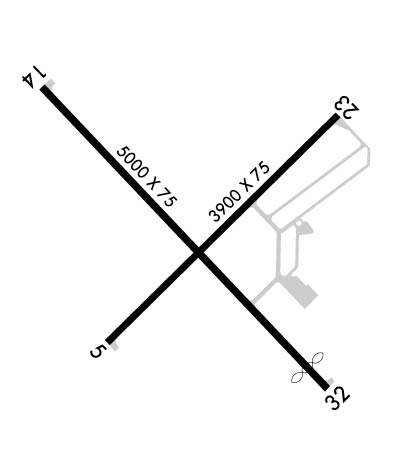
| Lat: N 4549.4 Long: W 09222.4 Elev: 989 Var: +01 Longest Runway: 5000 | ||
| AWOS: 118.32 CTAF: 122.8 | ||
| ||||||
| ||||||
|
| Rwy | Rwy | |||||||
| 3900x75 | 3900' | 3900x75 | 3900' | |||||
| 5000x75 | 5000' | 5000x75 | 4660' | |||||
| Runway ID | Single Wheel | Double Wheel | Double Tandem Wheel | Dual Double Wheel |
| 05/23 | 8,000 | N/A | N/A | N/A |
| 14/32 | 8,000 | N/A | N/A | N/A |
| These numbers are Advisory and are not limits. The Airport Manager should have more accurate Weight Limits | ||||
 Airport Diagram might not be current. | |
| Facility Name: | BURNETT COUNTY |
| City Name: | SIREN |
| County: | BURNETT |
| State abbrev: | WI |
| State Name: | WISCONSIN |
| Ownership: | PUBLICLY OWNED |
| Use: | OPEN TO THE PUBLIC |
| Owner's Name: | BURNETT COUNTY |
| Address: | 7410 CTH K |
| SIREN, WI 54872 | |
| Owner's Phone: | 715-349-2904 |
| Manager's Name: | NATHAN EHALT |
| Address: | 7410 CTH K, SUITE #116; EMAIL ADDRESS: NEHALT@BURNETTCOUNTY.ORG (ALL LOWER CASE) |
| SIREN, WI 54872 | |
| Phone: | 715-222-1702; AFT HRS CALL 715-222-1702 OR 715-566-2557. |
| FAA Region: | GREAT LAKES |
| FAA Field Office: | CHI |
| Date | Sunrise | Sunset |
|---|---|---|
| 05/07/24 Tuesday | 5:47 | 20:26 |
| 05/08/24 Wednesday | 5:46 | 20:27 |
| 05/09/24 Thursday | 5:44 | 20:28 |
| 05/10/24 Friday | 5:43 | 20:29 |
| 05/11/24 Saturday | 5:42 | 20:31 |
| 05/12/24 Sunday | 5:40 | 20:32 |
| 05/13/24 Monday | 5:39 | 20:33 |
| 05/14/24 Tuesday | 5:38 | 20:34 |
| 05/15/24 Wednesday | 5:37 | 20:35 |
| 05/16/24 Thursday | 5:36 | 20:37 |
| 05/17/24 Friday | 5:35 | 20:38 |
| 05/18/24 Saturday | 5:34 | 20:39 |
| 05/19/24 Sunday | 5:33 | 20:40 |
| 05/20/24 Monday | 5:32 | 20:41 |
| Airport Attendance Schedule | MON-FRI 0800-1630, SAT-SUN IREG |
| Airport Status | OPERATIONAL (This Status can change at any time - please check NOTAMS) |
| Airport Lighting Schedule | ACTVT REIL RWY 05, 23, 14 & 32; PAPI RWY 05, 23, 14 & 32; MIRL RWY 05/23 - CTAF. MIRL RWY 14/32 PRESET TO LOW SS-SR, TO INCR INTST & ACTVT - CTAF. |
| Airport Storage Available | Tie Downs, Hanger |
| Extra Services Available | NONE |
| Wind Indicator | YES - (lighted) |
| Control Tower | NO |
| CTAF Frequency | 122.800 |
| Unicom Frequency | 122.800 |
| Rotating Beacon Color | WG |
| Segmented Circle | YES |
| Landing Fee | NO |
| Airport Inspected | STATE - performed by STATE AERONAUTICAL PERSONNEL |
| Inspection Date | 08/04/2022 |
| Type of Fuel Available | Grade 100LL, JET A (freeze point -40C); -1024 HR SELF SVC. |
| Airframe Repair Service | MINOR |
| Power Plant Repair Service | MINOR |
| Latitude | N4549.4 |
| Longitude | W09222.4 (ESTIMATED) |
| Arpt Elevation | 989ft (SURVEYED) |
| Magnetic Variation | 01W |
| 3 miles N | of SIREN |
| Traffic Pattern Altitude | |
| Sectional Chart | GREEN BAY |
| Operations (Reported) | Yearly | Avg. Daily |
|---|---|---|
| General Aviation Transient | 6100 | 17 |
| General Aviation Local | 8400 | 23 |
| Air Taxi | 200 | 1 |
| Commerical | 0 | 0 |
| Commuter | 0 | 0 |
| Military | 0 | 0 |
| Aircraft based on Field | |
|---|---|
| General Aviation Singles | 22 |
| General Aviation Multi | 1 |
| Jet Aircraft | 0 |
| General Aviation Helicopters | 0 |
| Military Aircraft | 0 |
| Gliders | 0 |
| Ultralights | 0 |
| FSS on field | NO |
| FSS tie-in | GREEN BAY |
| FSS Phone | 1-800-WX-BRIEF |
| Who issues Notams | RZN |
| Notam D service at airport | YES |
| ARTCC Name | MINNEAPOLIS |
| Airport Certification | |
| Aircraft Rescue & Firefighting Index | None |
| Airport of Entry | No |
| Custom Landing Rights | No |
| Joint Civil/Military | No |
| Military Landing rights | No |
| NATIONAL PLAN OF INTEGRATED AIRPORT SYSTEMS (NPIAS) |
| GRANT AGREEMENT HAS EXPIRED; HOWEVER, AGREEMENT REMAINS IN EFFECT FOR THIS FACILITY AS LONG AS IT IS PUBLIC USE. |
| AGREEMENT UNDER DLAND OR DCLA HAS EXPIRED. |
| OCCASIONAL DEER & BEAR ON RY. |
| FOR CD CTC MINNEAPOLIS ARTCC AT 651-463-5588. |
Airport Communications & Frequencies:
| |||||||||
| Runway: 05 | Runway: 23 | ||
| Mag heading: | 46° | Mag heading: | 226° |
| Rwy Slope: | -.13% Down | Rwy Slope: | .13% Up |
| Approach: | Approach: | ||
| Pattern: | Left Traffic | Pattern: | Left Traffic |
| Markings: | NONPRECISION INSTRUMENT | Markings: | NONPRECISION INSTRUMENT |
| Marking Condition: | GOOD | Marking Condition: | GOOD |
| Arresting Dev: | Arresting Dev: | ||
| Lat & Long: | N4549.2 W09222.7 | Lat. & Long.: | N4549.6 W09222.0 |
| Elev: | 989.2 ft. MSL | Elev: | 984.0 ft. MSL |
| TCH: | 31 ft. AGL | TCH: | 27 ft. AGL |
| Visual Glide Path: | 3.50 degrees | Visual Glide Path: | 3.00 degrees |
| Displaced Threshold: | No | Displaced Threshold: | No |
| Touchdown Zone: | YES | Touchdown Zone: | YES |
| Touchdown Elev.: | 989.3 feet | Touchdown Elev.: | 988.5 feet |
| Visual Glide Slope: | 2-Light PAPI on LEFT side of Runway; UNUSBL BYD 5 DEGS RIGHT OF CNTRLN. | Visual Glide Slope: | 2-Light PAPI on LEFT side of Runway |
| RVR Equipment: | RVR Equipment: | ||
| RVV Equipment: | NO | RVV Equipment: | NO |
| Approach Lights: | Approach Lights: | ||
| REIL: | YES | REIL: | YES |
| Centerline Lights: | NO | Centerline Lights: | NO |
| Touchdown lights: | NO | Touchdown lights: | NO |
| Runway Category: | Runway with a Non-precision Approach | Runway Category: | Runway with a Non-precision Approach |
| Declared Distances: | Declared Distances: | ||
| Obstructions: | Obstructions: | ROAD | |
| Marked: | Marked: | LIGHTED | |
| Clearance slope: | 20:1 | Clearance slope: | 12:1 |
| Obstruction height: | Obstruction height: | 15 feet AGL | |
| Dist. from runway: | Dist. from runway: | 382 feet | |
| Centerline offset: | Centerline offset: | 277 feet left of centerline | |
| Comments: | Comments: |
| Runway: 14 | Runway: 32 | ||
| Mag heading: | 138° | Mag heading: | 318° |
| Rwy Slope: | .01% Up | Rwy Slope: | -.01% Down |
| Approach: | Approach: | ||
| Pattern: | Left Traffic | Pattern: | Left Traffic |
| Markings: | NONPRECISION INSTRUMENT | Markings: | NONPRECISION INSTRUMENT |
| Marking Condition: | GOOD | Marking Condition: | GOOD |
| Arresting Dev: | Arresting Dev: | ||
| Lat & Long: | N4549.7 W09222.9 | Lat. & Long.: | N4549.1 W09222.1 |
| Elev: | 987.2 ft. MSL | Elev: | 987.6 ft. MSL |
| TCH: | 28 ft. AGL | TCH: | 38 ft. AGL |
| Visual Glide Path: | 3.00 degrees | Visual Glide Path: | 4.00 degrees |
| Displaced Threshold: | No | Displaced Threshold: | 340 feet |
| Touchdown Zone: | YES | Touchdown Zone: | YES |
| Touchdown Elev.: | 988.0 feet | Touchdown Elev.: | 988.0 feet |
| Visual Glide Slope: | 2-Light PAPI on LEFT side of Runway | Visual Glide Slope: | 2-Light PAPI on LEFT side of Runway |
| RVR Equipment: | RVR Equipment: | ||
| RVV Equipment: | NO | RVV Equipment: | NO |
| Approach Lights: | Approach Lights: | ||
| REIL: | YES | REIL: | YES |
| Centerline Lights: | NO | Centerline Lights: | NO |
| Touchdown lights: | NO | Touchdown lights: | NO |
| Runway Category: | Runway with a Non-precision Approach | Runway Category: | Runway with a Non-precision Approach |
| Declared Distances: | Declared Distances: | ||
| Obstructions: | Obstructions: | TREES | |
| Marked: | Marked: | NOT Marked/Lighted | |
| Clearance slope: | 20:1 | Clearance slope: | 15:1; APCH RATIO 20:1 TO DSPLCD THR. |
| Obstruction height: | Obstruction height: | 78 feet AGL | |
| Dist. from runway: | Dist. from runway: | 1378 feet | |
| Centerline offset: | Centerline offset: | 115 feet left of centerline | |
| Comments: | Comments: |
Thanks for using FltPlan.com
all rights reserved © 1999-2024 by Flight Plan LLC
