
| CALDWELL MUNI CALDWELL TX |
| |
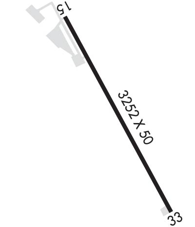
| Lat: N 3030.9 Long: W 09642.2 Elev: 391 Var: -06 Longest Runway: 3252 | ||
| AWOS: 118.35 CTAF: 122.9 | ||
| ||||||||||||||||||||||||||||||||||||||||||||
| ||||||||||||||||||||||||||||||||||||||||||||
| ||||||||||||||||||||||||||||||||||||||||||||
| Rwy | Rwy | |||||||
| 3252x50 | 3252' | 3252x50 | 3010' | |||||
| Runway ID | Single Wheel | Double Wheel | Double Tandem Wheel | Dual Double Wheel |
| 15/33 | 4,000 | N/A | N/A | N/A |
| These numbers are Advisory and are not limits. The Airport Manager should have more accurate Weight Limits | ||||
 Airport Diagram might not be current. | |
| Facility Name: | CALDWELL MUNI |
| City Name: | CALDWELL |
| County: | BURLESON |
| State abbrev: | TX |
| State Name: | TEXAS |
| Ownership: | PUBLICLY OWNED |
| Use: | OPEN TO THE PUBLIC |
| Owner's Name: | CITY OF CALDWELL |
| Address: | 107 S HILL |
| CALDWELL, TX 77836 | |
| Owner's Phone: | 979-567-3271 |
| Manager's Name: | THOMAS TRNKA; CITY MANAGER. |
| Address: | 107 S HILL |
| CALDWELL, TX 77836 | |
| Phone: | 979-599-4639; EXT 102. MGR CELL 979-406-0465 |
| FAA Region: | SOUTHWEST |
| FAA Field Office: | TEX |
| Date | Sunrise | Sunset |
|---|---|---|
| 04/25/24 Thursday | 6:48 | 20:02 |
| 04/26/24 Friday | 6:47 | 20:02 |
| 04/27/24 Saturday | 6:46 | 20:03 |
| 04/28/24 Sunday | 6:45 | 20:04 |
| 04/29/24 Monday | 6:44 | 20:04 |
| 04/30/24 Tuesday | 6:43 | 20:05 |
| 05/01/24 Wednesday | 6:42 | 20:06 |
| 05/02/24 Thursday | 6:42 | 20:06 |
| 05/03/24 Friday | 6:41 | 20:07 |
| 05/04/24 Saturday | 6:40 | 20:08 |
| 05/05/24 Sunday | 6:39 | 20:08 |
| 05/06/24 Monday | 6:38 | 20:09 |
| 05/07/24 Tuesday | 6:37 | 20:10 |
| 05/08/24 Wednesday | 6:37 | 20:10 |
| Airport Attendance Schedule | UNATTENDED |
| Airport Status | OPERATIONAL (This Status can change at any time - please check NOTAMS) |
| Airport Lighting Schedule | DUSK-DAWN, MIRL RWY 15/33 PRESET LOW INTST; TO INCR INTST AND ACTVT PAPI RWY 15 - CTAF. |
| Airport Storage Available | Tie Downs |
| Extra Services Available | NONE |
| Wind Indicator | YES - (lighted) |
| Control Tower | NO |
| CTAF Frequency | 122.900 |
| Unicom Frequency | |
| Rotating Beacon Color | WG |
| Segmented Circle | YES |
| Landing Fee | NO |
| Airport Inspected | STATE - performed by PRIVATE CONTRACT PERSONNEL |
| Inspection Date | 04/09/2023 |
| Type of Fuel Available | Grade 100LL |
| Airframe Repair Service | NONE |
| Power Plant Repair Service | NONE |
| Latitude | N3030.9 |
| Longitude | W09642.2 (ESTIMATED) |
| Arpt Elevation | 390ft (SURVEYED) |
| Magnetic Variation | 06E |
| 1 miles SW | of CALDWELL |
| Traffic Pattern Altitude | |
| Sectional Chart | HOUSTON |
| Operations (Reported) | Yearly | Avg. Daily |
|---|---|---|
| General Aviation Transient | 2100 | 6 |
| General Aviation Local | 5000 | 14 |
| Air Taxi | 0 | 0 |
| Commerical | 0 | 0 |
| Commuter | 0 | 0 |
| Military | 0 | 0 |
| Aircraft based on Field | |
|---|---|
| General Aviation Singles | 20 |
| General Aviation Multi | 1 |
| Jet Aircraft | 0 |
| General Aviation Helicopters | 0 |
| Military Aircraft | 0 |
| Gliders | 0 |
| Ultralights | 0 |
| FSS on field | NO |
| FSS tie-in | MONTGOMERY COUNTY |
| FSS Phone | 1-800-WX-BRIEF |
| Who issues Notams | RWV |
| Notam D service at airport | YES |
| ARTCC Name | HOUSTON |
| Airport Certification | |
| Aircraft Rescue & Firefighting Index | None |
| Airport of Entry | No |
| Custom Landing Rights | No |
| Joint Civil/Military | No |
| Military Landing rights | YES |
| GRANT AGREEMENTS UNDER FAAP/ADAP/AIP |
| ASSURANCES PURSUANT TO TITLE VI, CIVIL RIGHTS ACT OF 1964 |
| THIS AIRPORT HAS BEEN SURVEYED BY THE NATIONAL GEODETIC SURVEY. |
| FOR CD CTC HOUSTON APCH AT 281-443-5844 TO CNL IFR CALL 281-443-5888. |
| RWY 15, 17 FT BLDG. PENETRATES TRSN SFC, 104 FT FM RWY END, 260 FT R. |
| RWY 15/3 3 PHOTOCELL SENSOR. |
Airport Communications & Frequencies:
| ||||||||||||
| Runway: 15 | Runway: 33 | ||
| Mag heading: | 146° | Mag heading: | 326° |
| Rwy Slope: | -.86% Down | Rwy Slope: | .86% Up |
| Approach: | Approach: | ||
| Pattern: | Left Traffic | Pattern: | Left Traffic |
| Markings: | BASIC | Markings: | BASIC |
| Marking Condition: | GOOD | Marking Condition: | GOOD |
| Arresting Dev: | Arresting Dev: | ||
| Lat & Long: | N3031.2 W09642.4 | Lat. & Long.: | N3030.7 W09642.1 |
| Elev: | 390.6 ft. MSL | Elev: | 362.7 ft. MSL |
| TCH: | 42 ft. AGL | TCH: | |
| Visual Glide Path: | 3.00 degrees | Visual Glide Path: | |
| Displaced Threshold: | No | Displaced Threshold: | 242 feet |
| Touchdown Zone: | YES | Touchdown Zone: | YES |
| Touchdown Elev.: | 390.6 feet | Touchdown Elev.: | 390.3 feet |
| Visual Glide Slope: | 2-Light PAPI on LEFT side of Runway | Visual Glide Slope: | |
| RVR Equipment: | RVR Equipment: | ||
| RVV Equipment: | NO | RVV Equipment: | NO |
| Approach Lights: | Approach Lights: | ||
| REIL: | NO | REIL: | NO |
| Centerline Lights: | NO | Centerline Lights: | NO |
| Touchdown lights: | NO | Touchdown lights: | NO |
| Runway Category: | Runway with a Non-precision Approach | Runway Category: | Runway with a Non-precision Approach |
| Declared Distances: | Declared Distances: | ||
| Obstructions: | TREES | Obstructions: | TREES |
| Marked: | NOT Marked/Lighted | Marked: | NOT Marked/Lighted |
| Clearance slope: | CTLG OBSTN EXCEEDS A 45 DEG SLOPE. | Clearance slope: | 7:1; APCH SLOPE 16:1 TO DSPLCD THR. |
| Obstruction height: | 35 feet AGL | Obstruction height: | 50 feet AGL |
| Dist. from runway: | 201 feet | Dist. from runway: | 585 feet |
| Centerline offset: | 190 left of centerline | Centerline offset: | 100 feet left of centerline |
| Comments: | 30 FT TREES, 131-201 FT DSTC, 189-250 FT L. | Comments: | 20 FT TREES, 120 FT DSTC, 200 FT L. |
Thanks for using FltPlan.com
all rights reserved © 1999-2024 by Flight Plan LLC
