
| ROCKWOOD MUNI ROCKWOOD TN |
| |
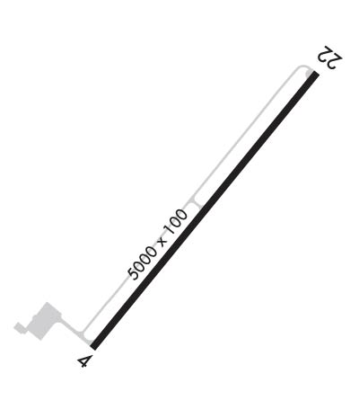
| Lat: N 3555.3 Long: W 08441.4 Elev: 1664 Var: +05 Longest Runway: 5000 | ||
| AWOS: 118.77 CTAF: 122.8 | ||
| ||||||
| ||||||
|
| Rwy | Rwy | |||||||
| 5000x100 | 5000' | 5000x100 | 5000' | |||||
| Runway ID | Single Wheel | Double Wheel | Double Tandem Wheel | Dual Double Wheel |
| 04/22 | 30,000 | 38,000 | N/A | N/A |
| These numbers are Advisory and are not limits. The Airport Manager should have more accurate Weight Limits | ||||
 Airport Diagram might not be current. | |
| Facility Name: | ROCKWOOD MUNI |
| City Name: | ROCKWOOD |
| County: | MORGAN |
| State abbrev: | TN |
| State Name: | TENNESSEE |
| Ownership: | PUBLICLY OWNED |
| Use: | OPEN TO THE PUBLIC |
| Owner's Name: | CITY OF ROCKWOOD |
| Address: | 110 N CHAMBERLAIN |
| ROCKWOOD, TN 37854 | |
| Owner's Phone: | (865) 354-0611 |
| Manager's Name: | DUKE SPRADLING |
| Address: | 258 ROCKWOOD AIRPORT DR |
| ROCKWOOD, TN 37854 | |
| Phone: | 865-354-3023 |
| FAA Region: | SOUTHERN |
| FAA Field Office: | MEM |
| Date | Sunrise | Sunset |
|---|---|---|
| 04/25/24 Thursday | 6:52 | 20:21 |
| 04/26/24 Friday | 6:51 | 20:22 |
| 04/27/24 Saturday | 6:50 | 20:23 |
| 04/28/24 Sunday | 6:49 | 20:24 |
| 04/29/24 Monday | 6:48 | 20:25 |
| 04/30/24 Tuesday | 6:47 | 20:26 |
| 05/01/24 Wednesday | 6:46 | 20:27 |
| 05/02/24 Thursday | 6:44 | 20:27 |
| 05/03/24 Friday | 6:43 | 20:28 |
| 05/04/24 Saturday | 6:42 | 20:29 |
| 05/05/24 Sunday | 6:41 | 20:30 |
| 05/06/24 Monday | 6:40 | 20:31 |
| 05/07/24 Tuesday | 6:39 | 20:32 |
| 05/08/24 Wednesday | 6:38 | 20:32 |
| Airport Attendance Schedule | MON-FRI IRG, SAT IRG |
| Airport Status | OPERATIONAL (This Status can change at any time - please check NOTAMS) |
| Airport Lighting Schedule | ACTVT REIL RWY 04 & 22; MIRL RWY 04/22 - CTAF. REIL RWY 04 & 22; MIRL RWY 04/22 PRESET LOW INTST; INCR INTST - CTAF. PAPI RWY 04 & 22 OPR CONSLY. |
| Airport Storage Available | Tie Downs, Hanger |
| Extra Services Available | NONE |
| Wind Indicator | YES - (lighted) |
| Control Tower | NO |
| CTAF Frequency | 122.800 |
| Unicom Frequency | 122.800 |
| Rotating Beacon Color | WG |
| Segmented Circle | YES |
| Landing Fee | NO |
| Airport Inspected | STATE - performed by STATE AERONAUTICAL PERSONNEL |
| Inspection Date | 04/13/2021 |
| Type of Fuel Available | Grade 100LL, JET A (freeze point -40C) |
| Airframe Repair Service | MAJOR |
| Power Plant Repair Service | MAJOR |
| Latitude | N3555.3 |
| Longitude | W08441.4 (ESTIMATED) |
| Arpt Elevation | 1664ft (SURVEYED) |
| Magnetic Variation | 05W |
| 3 miles N | of ROCKWOOD |
| Traffic Pattern Altitude | |
| Sectional Chart | ATLANTA |
| Operations (Reported) | Yearly | Avg. Daily |
|---|---|---|
| General Aviation Transient | 3100 | 8 |
| General Aviation Local | 9300 | 25 |
| Air Taxi | 774 | 2 |
| Commerical | 0 | 0 |
| Commuter | 0 | 0 |
| Military | 4380 | 12 |
| Aircraft based on Field | |
|---|---|
| General Aviation Singles | 12 |
| General Aviation Multi | 3 |
| Jet Aircraft | 0 |
| General Aviation Helicopters | 1 |
| Military Aircraft | 0 |
| Gliders | 0 |
| Ultralights | 0 |
| FSS on field | NO |
| FSS tie-in | NASHVILLE |
| FSS Phone | 1-800-WX-BRIEF |
| Who issues Notams | BNA |
| Notam D service at airport | YES |
| ARTCC Name | ATLANTA |
| Airport Certification | |
| Aircraft Rescue & Firefighting Index | None |
| Airport of Entry | No |
| Custom Landing Rights | No |
| Joint Civil/Military | No |
| Military Landing rights | YES |
| NATIONAL PLAN OF INTEGRATED AIRPORT SYSTEMS (NPIAS) |
| ASSURANCES PURSUANT TO TITLE VI, CIVIL RIGHTS ACT OF 1964 |
| GRANT AGREEMENT HAS EXPIRED; HOWEVER, AGREEMENT REMAINS IN EFFECT FOR THIS FACILITY AS LONG AS IT IS PUBLIC USE. |
| THIS AIRPORT HAS BEEN SURVEYED BY THE NATIONAL GEODETIC SURVEY. |
| ACFT TAXIING NOT VISIBLE FROM ENDS OF RY. |
| FOR CD CTC ATLANTA ARTCC AT 770-210-7692. |
Airport Communications & Frequencies:
| |||||||||
| Runway: 04 | Runway: 22 | ||
| Mag heading: | 44° | Mag heading: | 224° |
| Rwy Slope: | -.59% Down | Rwy Slope: | .59% Up |
| Approach: | Approach: | ||
| Pattern: | Left Traffic | Pattern: | Left Traffic |
| Markings: | NONPRECISION INSTRUMENT | Markings: | NONPRECISION INSTRUMENT |
| Marking Condition: | GOOD | Marking Condition: | GOOD |
| Arresting Dev: | Arresting Dev: | ||
| Lat & Long: | N3555.0 W08441.7 | Lat. & Long.: | N3555.7 W08441.1 |
| Elev: | 1659.0 ft. MSL | Elev: | 1629.7 ft. MSL |
| TCH: | 26 ft. AGL | TCH: | 31 ft. AGL |
| Visual Glide Path: | 3.00 degrees | Visual Glide Path: | 3.00 degrees |
| Displaced Threshold: | No | Displaced Threshold: | No |
| Touchdown Zone: | YES | Touchdown Zone: | YES |
| Touchdown Elev.: | 1664.1 feet | Touchdown Elev.: | 1662.0 feet |
| Visual Glide Slope: | 2-Light PAPI on LEFT side of Runway | Visual Glide Slope: | 2-Light PAPI on LEFT side of Runway |
| RVR Equipment: | RVR Equipment: | ||
| RVV Equipment: | NO | RVV Equipment: | NO |
| Approach Lights: | Approach Lights: | ||
| REIL: | YES | REIL: | YES |
| Centerline Lights: | NO | Centerline Lights: | NO |
| Touchdown lights: | NO | Touchdown lights: | NO |
| Runway Category: | Runway with a Non-precision Approach having visibility minimums greater than 3/4 mile | Runway Category: | Runway with a Non-precision Approach having visibility minimums greater than 3/4 mile |
| Declared Distances: | Declared Distances: |
Thanks for using FltPlan.com
all rights reserved © 1999-2024 by Flight Plan LLC
