| FLABOB RIVERSIDE/RUBIDOUX/ CA |
| |
| Lat: N 3359.3 Long: W 11724.6 Elev: 767 Var: -13 Longest Runway: 3190 | ||
| CTAF: 122.8 | ||
| |||||||||||||||||||||||||||||||||||||||||||||||||||||||||||||
| |||||||||||||||||||||||||||||||||||||||||||||||||||||||||||||
| Rwy | Rwy | |||||||
| 3190x50 | 3190' | 3190x50 | 3190' | |||||
| Runway ID | Single Wheel | Double Wheel | Double Tandem Wheel | Dual Double Wheel |
| 06/24 | N/A | N/A | N/A | N/A |
| These numbers are Advisory and are not limits. The Airport Manager should have more accurate Weight Limits | ||||
 Airport Diagram might not be current. | |
| Facility Name: | FLABOB |
| City Name: | RIVERSIDE/RUBIDOUX/ |
| County: | RIVERSIDE |
| State abbrev: | CA |
| State Name: | CALIFORNIA |
| Ownership: | PRIVATELY OWNED |
| Use: | OPEN TO THE PUBLIC |
| Owner's Name: | FLABOB AIRPORT, LLC |
| Address: | 4130 MENNES AVE |
| RIVERSIDE, CA 92509 | |
| Owner's Phone: | 951-683-2309 |
| Manager's Name: | BETH LAROCK |
| Address: | 4130 MENNES AVE |
| RIVERSIDE, CA 92509 | |
| Phone: | 951-683-2309 |
| FAA Region: | WESTERN-PACIFIC |
| FAA Field Office: | LAX |
| Date | Sunrise | Sunset |
|---|---|---|
| 04/25/24 Thursday | 6:06 | 19:29 |
| 04/26/24 Friday | 6:05 | 19:30 |
| 04/27/24 Saturday | 6:04 | 19:31 |
| 04/28/24 Sunday | 6:03 | 19:32 |
| 04/29/24 Monday | 6:02 | 19:33 |
| 04/30/24 Tuesday | 6:01 | 19:33 |
| 05/01/24 Wednesday | 6:00 | 19:34 |
| 05/02/24 Thursday | 5:59 | 19:35 |
| 05/03/24 Friday | 5:58 | 19:36 |
| 05/04/24 Saturday | 5:57 | 19:36 |
| 05/05/24 Sunday | 5:56 | 19:37 |
| 05/06/24 Monday | 5:55 | 19:38 |
| 05/07/24 Tuesday | 5:54 | 19:39 |
| 05/08/24 Wednesday | 5:53 | 19:40 |
| Airport Attendance Schedule | MON-FRI 0830-1630 |
| Airport Status | OPERATIONAL (This Status can change at any time - please check NOTAMS) |
| Airport Lighting Schedule | DUSK-DAWN. ACTVT MIRL RY 06/24 - CTAF. |
| Airport Storage Available | Tie Downs |
| Extra Services Available | Flight Instruction |
| Wind Indicator | YES - (lighted) |
| Control Tower | NO |
| CTAF Frequency | 122.800 |
| Unicom Frequency | 122.800 |
| Rotating Beacon Color | |
| Segmented Circle | NO |
| Landing Fee | NO |
| Airport Inspected | STATE - performed by STATE AERONAUTICAL PERSONNEL |
| Inspection Date | 03/03/2023 |
| Type of Fuel Available | Grade 100LL |
| Airframe Repair Service | MAJOR |
| Power Plant Repair Service | MAJOR |
| Latitude | N3359.3 |
| Longitude | W11724.6 (ESTIMATED) |
| Arpt Elevation | 767ft (ESTIMATED) |
| Magnetic Variation | 13E |
| 3 miles NW | of RIVERSIDE/RUBIDOUX/ |
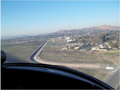
| Traffic Pattern Altitude | 700; NIGHT TPA 1000 FT AGL AROUND THE MOUNTAIN. |
| Sectional Chart | LOS ANGELES |
| Operations (Reported) | Yearly | Avg. Daily |
|---|---|---|
| General Aviation Transient | 3100 | 8 |
| General Aviation Local | 8200 | 22 |
| Air Taxi | 0 | 0 |
| Commerical | 0 | 0 |
| Commuter | 0 | 0 |
| Military | 0 | 0 |
| Aircraft based on Field | |
|---|---|
| General Aviation Singles | 115 |
| General Aviation Multi | 12 |
| Jet Aircraft | 0 |
| General Aviation Helicopters | 0 |
| Military Aircraft | 0 |
| Gliders | 0 |
| Ultralights | 0 |
| FSS on field | NO |
| FSS tie-in | RIVERSIDE |
| FSS Phone | 1-800-WX-BRIEF |
| Who issues Notams | RAL |
| Notam D service at airport | YES |
| ARTCC Name | LOS ANGELES |
| Airport Certification | |
| Aircraft Rescue & Firefighting Index | None |
| Airport of Entry | No |
| Custom Landing Rights | No |
| Joint Civil/Military | No |
| Military Landing rights | No |
| MTN 1340 FT MSL 3/4 MILE SE OF ARPT +20 FT CROSS ON TOP. |
| DEPARTURES TO THE SOUTH CTC RIVERSIDE ATCT. |
| RY 24 AFT TKOF TURN LEFT 10 DEG; STAY NORTH OF RIVERBED. |
| RY 24 CALM WIND RY. |
| FOR CD CTC SOCAL APCH AT 800-448-3724. |
| RWY 06/2 4 RWY 06/24 NSTD MIRL GTR THAN 10 FT FROM RWY EDGE. |
Airport Communications & Frequencies:
| ||||||||||||||||||
| Runway: 06 | Runway: 24 | ||
| Mag heading: | 64° | Mag heading: | 244° |
| Rwy Slope: | .52% Up | Rwy Slope: | -.52% Down |
| Approach: | Approach: | ||
| Pattern: | Left Traffic | Pattern: | Left Traffic |
| Markings: | NONPRECISION INSTRUMENT | Markings: | NONPRECISION INSTRUMENT |
| Marking Condition: | GOOD | Marking Condition: | GOOD |
| Arresting Dev: | Arresting Dev: | ||
| Lat & Long: | N3359.3 W11724.9 | Lat. & Long.: | N3359.4 W11724.3 |
| Elev: | 750.3 ft. MSL | Elev: | 766.8 ft. MSL |
| TCH: | TCH: | ||
| Visual Glide Path: | Visual Glide Path: | ||
| Displaced Threshold: | No | Displaced Threshold: | No |
| Touchdown Zone: | YES | Touchdown Zone: | YES |
| Touchdown Elev.: | 766.8 feet | Touchdown Elev.: | 766.8 feet |
| Visual Glide Slope: | Visual Glide Slope: | ||
| RVR Equipment: | RVR Equipment: | ||
| RVV Equipment: | NO | RVV Equipment: | NO |
| Approach Lights: | Approach Lights: | ||
| REIL: | NO | REIL: | NO |
| Centerline Lights: | NO | Centerline Lights: | NO |
| Touchdown lights: | NO | Touchdown lights: | NO |
| Runway Category: | Runway with a Visual Approach | Runway Category: | Runway with a Visual Approach |
| Declared Distances: | Declared Distances: | ||
| Obstructions: | TREES | Obstructions: | |
| Marked: | NOT Marked/Lighted | Marked: | |
| Clearance slope: | 4:1 | Clearance slope: | 20:1 |
| Obstruction height: | 25 feet AGL | Obstruction height: | |
| Dist. from runway: | 310 feet | Dist. from runway: | |
| Centerline offset: | Centerline offset: | ||
| Comments: | Comments: |
Thanks for using FltPlan.com
all rights reserved © 1999-2024 by Flight Plan LLC