
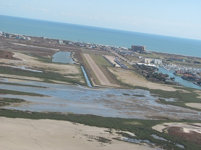
| MUSTANG BEACH PORT ARANSAS TX |
| |
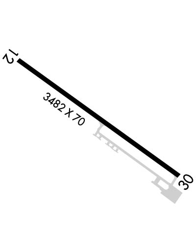
| Lat: N 2748.7 Long: W 09705.3 Elev: 5 Var: -05 Longest Runway: 3482 | ||
| AWOS: 118.42 CTAF: 122.9 | ||
| ||||||
| ||||||
|
| Rwy | Rwy | |||||||
| 3482x70 | 3482' | 3482x70 | 3482' | |||||
| Runway ID | Single Wheel | Double Wheel | Double Tandem Wheel | Dual Double Wheel |
| 12/30 | N/A | N/A | N/A | N/A |
| These numbers are Advisory and are not limits. The Airport Manager should have more accurate Weight Limits | ||||
 Airport Diagram might not be current. | |
| Facility Name: | MUSTANG BEACH |
| City Name: | PORT ARANSAS |
| County: | NUECES |
| State abbrev: | TX |
| State Name: | TEXAS |
| Ownership: | PUBLICLY OWNED |
| Use: | OPEN TO THE PUBLIC |
| Owner's Name: | CITY OF PORT ARANSAS |
| Address: | 710 W. AVE A |
| PORT ARANSAS, TX 78373-4128 | |
| Owner's Phone: | 361-749-4111 |
| Manager's Name: | DAVID PARSONS |
| Address: | 710 W. AVE A |
| PORT ARANSAS, TX 78373-4128 | |
| Phone: | 361-749-4008 |
| FAA Region: | SOUTHWEST |
| FAA Field Office: | TEX |
| Date | Sunrise | Sunset |
|---|---|---|
| 04/25/24 Thursday | 6:53 | 20:00 |
| 04/26/24 Friday | 6:52 | 20:00 |
| 04/27/24 Saturday | 6:51 | 20:01 |
| 04/28/24 Sunday | 6:51 | 20:01 |
| 04/29/24 Monday | 6:50 | 20:02 |
| 04/30/24 Tuesday | 6:49 | 20:02 |
| 05/01/24 Wednesday | 6:48 | 20:03 |
| 05/02/24 Thursday | 6:47 | 20:04 |
| 05/03/24 Friday | 6:47 | 20:04 |
| 05/04/24 Saturday | 6:46 | 20:05 |
| 05/05/24 Sunday | 6:45 | 20:05 |
| 05/06/24 Monday | 6:44 | 20:06 |
| 05/07/24 Tuesday | 6:44 | 20:06 |
| 05/08/24 Wednesday | 6:43 | 20:07 |
| Airport Attendance Schedule | IRREGULAR |
| Airport Status | OPERATIONAL (This Status can change at any time - please check NOTAMS) |
| Airport Lighting Schedule | SS-SR |
| Airport Storage Available | Tie Downs |
| Extra Services Available | Parachute Jumping |
| Wind Indicator | YES - (lighted) |
| Control Tower | NO |
| CTAF Frequency | 122.900 |
| Unicom Frequency | |
| Rotating Beacon Color | WG |
| Segmented Circle | YES |
| Landing Fee | NO; OVERNIGHT TIEDOWN FEE. |
| Airport Inspected | STATE - performed by PRIVATE CONTRACT PERSONNEL |
| Inspection Date | 04/18/2023 |
| Type of Fuel Available | Grade 100LL; -10FUEL 24 HR SELF SERV. |
| Airframe Repair Service | None |
| Power Plant Repair Service | None |
| Latitude | N2748.7 |
| Longitude | W09705.3 (ESTIMATED) |
| Arpt Elevation | 5ft (SURVEYED) |
| Magnetic Variation | 05E |
| 2 miles SW | of PORT ARANSAS |
| Traffic Pattern Altitude | |
| Sectional Chart | BROWNSVILLE |
| Operations (Reported) | Yearly | Avg. Daily |
|---|---|---|
| General Aviation Transient | 3000 | 8 |
| General Aviation Local | 324 | 1 |
| Air Taxi | 0 | 0 |
| Commerical | 0 | 0 |
| Commuter | 0 | 0 |
| Military | 0 | 0 |
| Aircraft based on Field | |
|---|---|
| General Aviation Singles | 9 |
| General Aviation Multi | 1 |
| Jet Aircraft | 0 |
| General Aviation Helicopters | 0 |
| Military Aircraft | 0 |
| Gliders | 0 |
| Ultralights | 0 |
| FSS on field | NO |
| FSS tie-in | SAN ANGELO |
| FSS Phone | 1-800-WX-BRIEF |
| Who issues Notams | RAS |
| Notam D service at airport | YES |
| ARTCC Name | HOUSTON |
| Airport Certification | |
| Aircraft Rescue & Firefighting Index | None |
| Airport of Entry | No |
| Custom Landing Rights | No |
| Joint Civil/Military | No |
| Military Landing rights | No |
| RY 12 HAS A -3 FT DROP OFF NEAR END OF RY; RY 30 HAS A 3 FT DITCH 180 FT FM END OF RY. |
| RY 30 29 FT POWER LINE 1133 FT FM THLD L AND R OF CNTRLN. 48 FT POWER LINE 1791 FT FM THLD L AND R OF CNTRLN. |
| FOR CD CTC CORPUS CHRISTI APCH AT 361-299-4230. |
| RWY 12/3 0 RWY SFC SEAL-PEASTONES. CONSIDERABEL AMT OF LOOSE STONES ON RWY & TWY. |
Airport Communications & Frequencies:
| ||||||||||||
| Runway: 12 | Runway: 30 | ||
| Mag heading: | 120° | Mag heading: | 300° |
| Rwy Slope: | .00% Up | Rwy Slope: | .00% Down |
| Approach: | Approach: | ||
| Pattern: | Left Traffic | Pattern: | Left Traffic |
| Markings: | NONPRECISION INSTRUMENT | Markings: | NONPRECISION INSTRUMENT |
| Marking Condition: | FAIR | Marking Condition: | FAIR |
| Arresting Dev: | Arresting Dev: | ||
| Lat & Long: | N2748.9 W09705.6 | Lat. & Long.: | N2748.5 W09705.1 |
| Elev: | 4.4 ft. MSL | Elev: | 4.5 ft. MSL |
| TCH: | 20 ft. AGL | TCH: | 22 ft. AGL |
| Visual Glide Path: | 3.00 degrees | Visual Glide Path: | 3.20 degrees |
| Displaced Threshold: | No | Displaced Threshold: | No |
| Touchdown Zone: | YES | Touchdown Zone: | YES |
| Touchdown Elev.: | 5.0 feet | Touchdown Elev.: | 5.0 feet |
| Visual Glide Slope: | 2-Light PAPI on LEFT side of Runway | Visual Glide Slope: | 2-Light PAPI on LEFT side of Runway |
| RVR Equipment: | RVR Equipment: | ||
| RVV Equipment: | NO | RVV Equipment: | NO |
| Approach Lights: | Approach Lights: | ||
| REIL: | NO | REIL: | NO |
| Centerline Lights: | NO | Centerline Lights: | NO |
| Touchdown lights: | NO | Touchdown lights: | NO |
| Runway Category: | Runway with a Non-precision Approach | Runway Category: | Runway with a Non-precision Approach |
| Declared Distances: | Declared Distances: | ||
| Obstructions: | Obstructions: | TREE | |
| Marked: | Marked: | NOT Marked/Lighted | |
| Clearance slope: | 50:1 | Clearance slope: | |
| Obstruction height: | Obstruction height: | 22 feet AGL | |
| Dist. from runway: | Dist. from runway: | 200 feet | |
| Centerline offset: | Centerline offset: | 244 feet left of centerline | |
| Comments: | Comments: | 3 FT SIGN AND PARKED ACFT 0 FT - 190 FT AT 189 FT L, 8 FT DIRT MOUND 85 FT - 256 FT FM THLD AT 125 FT L. |
Thanks for using FltPlan.com
all rights reserved © 1999-2024 by Flight Plan LLC