
| PORTERVILLE MUNI PORTERVILLE CA |
| |
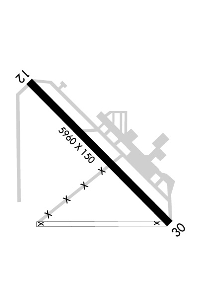
| Lat: N 3601.8 Long: W 11903.8 Elev: 443 Var: -15 Longest Runway: 5960 | ||
| AWOS: 134.62 CTAF: 122.8 | ||
| ||||||||||||||||||||||||||||||||||||||||||||
| ||||||||||||||||||||||||||||||||||||||||||||
| ||||||||||||||||||||||||||||||||||||||||||||
| Rwy | Rwy | |||||||
| 5960x150 | 5960' | 5960x150 | 5960' | |||||
| Runway ID | Single Wheel | Double Wheel | Double Tandem Wheel | Dual Double Wheel |
| 12/30 | 30,000 | 70,000 | 110,000 | N/A |
| These numbers are Advisory and are not limits. The Airport Manager should have more accurate Weight Limits | ||||
 Airport Diagram might not be current. | |
| Facility Name: | PORTERVILLE MUNI |
| City Name: | PORTERVILLE |
| County: | TULARE |
| State abbrev: | CA |
| State Name: | CALIFORNIA |
| Ownership: | PUBLICLY OWNED |
| Use: | OPEN TO THE PUBLIC |
| Owner's Name: | CITY OF PORTERVILLE |
| Address: | 291 N. MAIN STREET |
| PORTERVILLE, CA 93257-7466 | |
| Owner's Phone: | 559-782-7540 |
| Manager's Name: | ANDRE LABONTE; ARPT OPERATIONS MANGER: JIM MCDONALD; PHONE (559) 782-7540. |
| Address: | 1893 SOUTH NEWCOMB ROAD; EMERGENCY CONTACT PORTERVILLE PD 559-782-7400 |
| PORTERVILLE, CA 93257-7466 | |
| Phone: | 559-782-7540 |
| FAA Region: | WESTERN-PACIFIC |
| FAA Field Office: | SFO |
| Date | Sunrise | Sunset |
|---|---|---|
| 04/25/24 Thursday | 6:09 | 19:39 |
| 04/26/24 Friday | 6:08 | 19:40 |
| 04/27/24 Saturday | 6:07 | 19:41 |
| 04/28/24 Sunday | 6:06 | 19:42 |
| 04/29/24 Monday | 6:05 | 19:43 |
| 04/30/24 Tuesday | 6:04 | 19:43 |
| 05/01/24 Wednesday | 6:03 | 19:44 |
| 05/02/24 Thursday | 6:02 | 19:45 |
| 05/03/24 Friday | 6:01 | 19:46 |
| 05/04/24 Saturday | 6:00 | 19:47 |
| 05/05/24 Sunday | 5:59 | 19:48 |
| 05/06/24 Monday | 5:58 | 19:49 |
| 05/07/24 Tuesday | 5:57 | 19:49 |
| 05/08/24 Wednesday | 5:56 | 19:50 |
| Airport Attendance Schedule | MAY-OCT 7 Days A Week 0700-1900, NOV-APR 7 Days A Week 0800-1700; ARPT ATTENDANT 559-782-7540. |
| Airport Status | OPERATIONAL (This Status can change at any time - please check NOTAMS) |
| Airport Lighting Schedule | HIRL RY 12/30 PRESET LOW INTST DUSK-2300; AFTER 2300 ACTVT - CTAF. ACTVT VASI RY 12 - CTAF, VASI RY 30 OPER CONTINUOUSLY. |
| Airport Storage Available | Tie Downs |
| Extra Services Available | Charter, Flight Instruction, Aircraft Rental, Aircraft Sales, Annual Surveying |
| Wind Indicator | YES - (lighted) |
| Control Tower | NO |
| CTAF Frequency | 122.800 |
| Unicom Frequency | 122.800 |
| Rotating Beacon Color | WG |
| Segmented Circle | YES |
| Landing Fee | NO |
| Airport Inspected | STATE - performed by STATE AERONAUTICAL PERSONNEL |
| Inspection Date | 06/21/2023 |
| Type of Fuel Available | Grade 100LL, JET A (freeze point -40C); -10SELF SERVICE FUEL AVBL 24 HRS WITH CREDIT CARD. |
| Airframe Repair Service | MAJOR |
| Power Plant Repair Service | MAJOR |
| Latitude | N3601.8 |
| Longitude | W11903.8 (ESTIMATED) |
| Arpt Elevation | 443ft (SURVEYED) |
| Magnetic Variation | 15E |
| 3 miles SW | of PORTERVILLE |
| Traffic Pattern Altitude | |
| Sectional Chart | SAN FRANCISCO |
| Operations (Reported) | Yearly | Avg. Daily |
|---|---|---|
| General Aviation Transient | 27500 | 75 |
| General Aviation Local | 15000 | 41 |
| Air Taxi | 1000 | 3 |
| Commerical | 0 | 0 |
| Commuter | 0 | 0 |
| Military | 50 | 0 |
| Aircraft based on Field | |
|---|---|
| General Aviation Singles | 31 |
| General Aviation Multi | 1 |
| Jet Aircraft | 0 |
| General Aviation Helicopters | 4 |
| Military Aircraft | 0 |
| Gliders | 0 |
| Ultralights | 0 |
| FSS on field | NO |
| FSS tie-in | RANCHO MURIETA |
| FSS Phone | 1-800-WX-BRIEF |
| Who issues Notams | PTV |
| Notam D service at airport | YES |
| ARTCC Name | LOS ANGELES |
| Airport Certification | |
| Aircraft Rescue & Firefighting Index | None |
| Airport of Entry | No |
| Custom Landing Rights | No |
| Joint Civil/Military | No |
| Military Landing rights | YES |
| NATIONAL PLAN OF INTEGRATED AIRPORT SYSTEMS (NPIAS) |
| GRANT AGREEMENTS UNDER FAAP/ADAP/AIP |
| SURPLUS PROPERTY AGREEMENT UNDER REGULATION 16-WAA |
| ASSURANCES PURSUANT TO TITLE VI, CIVIL RIGHTS ACT OF 1964 |
Airport Communications & Frequencies:
| |||||||||||||
| Runway: 12 | Runway: 30 | ||
| Mag heading: | 120° | Mag heading: | 300° |
| Rwy Slope: | .20% Up | Rwy Slope: | -.20% Down |
| Approach: | Approach: | ||
| Pattern: | Left Traffic | Pattern: | Left Traffic |
| Markings: | NONPRECISION INSTRUMENT | Markings: | NONPRECISION INSTRUMENT |
| Marking Condition: | FAIR | Marking Condition: | FAIR |
| Arresting Dev: | Arresting Dev: | ||
| Lat & Long: | N3602.1 W11904.2 | Lat. & Long.: | N3601.4 W11903.3 |
| Elev: | 431.2 ft. MSL | Elev: | 443.1 ft. MSL |
| TCH: | 29 ft. AGL | TCH: | 60 ft. AGL |
| Visual Glide Path: | 3.00 degrees | Visual Glide Path: | 3.00 degrees |
| Displaced Threshold: | No | Displaced Threshold: | No |
| Touchdown Zone: | YES | Touchdown Zone: | YES |
| Touchdown Elev.: | 438.4 feet | Touchdown Elev.: | 443.2 feet |
| Visual Glide Slope: | 4-BOX VASI ON RIGHT SIDE OF RUNWAY | Visual Glide Slope: | 4-BOX VASI ON RIGHT SIDE OF RUNWAY |
| RVR Equipment: | RVR Equipment: | ||
| RVV Equipment: | NO | RVV Equipment: | NO |
| Approach Lights: | Approach Lights: | ||
| REIL: | NO | REIL: | YES |
| Centerline Lights: | NO | Centerline Lights: | NO |
| Touchdown lights: | NO | Touchdown lights: | NO |
| Runway Category: | Runway with a Non-precision Approach having visibility minimums greater than 3/4 mile | Runway Category: | Runway with a Non-precision Approach having visibility minimums greater than 3/4 mile |
| Declared Distances: | Declared Distances: | ||
| Obstructions: | ROAD | Obstructions: | ROAD |
| Marked: | NOT Marked/Lighted | Marked: | NOT Marked/Lighted |
| Clearance slope: | 18:1 | Clearance slope: | 21:1 |
| Obstruction height: | 15 feet AGL | Obstruction height: | 15 feet AGL |
| Dist. from runway: | 480 feet | Dist. from runway: | 520 feet |
| Centerline offset: | 292 left of centerline | Centerline offset: | 298 feet left of centerline |
| Comments: | Comments: |
Thanks for using FltPlan.com
all rights reserved © 1999-2024 by Flight Plan LLC
