| TRI-CITY PARSONS KS |
| |
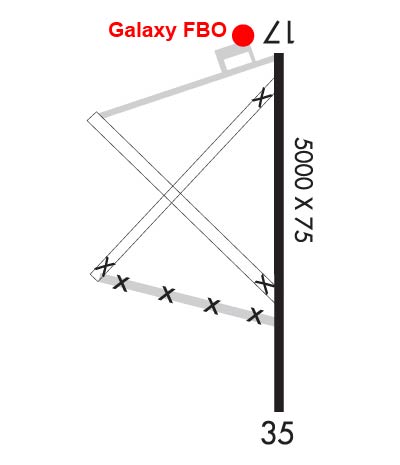
| Lat: N 3719.8 Long: W 09530.4 Elev: 901 Var: -06 Longest Runway: 5001 | ||
| AWOS: 118.17 CTAF: 123.0 | ||
| |||||||||||||||||||||||||||||||
| |||||||||||||||||||||||||||||||
| |||||||||||||||||||||||||||||||
| Rwy | Rwy | |||||||
| 5001x75 | 5001' | 5001x75 | 5001' | |||||
| Runway ID | Single Wheel | Double Wheel | Double Tandem Wheel | Dual Double Wheel |
| 17/35 | 25,000 | 45,000 | N/A | N/A |
| These numbers are Advisory and are not limits. The Airport Manager should have more accurate Weight Limits | ||||
 Airport Diagram might not be current. | |
| Facility Name: | TRI-CITY |
| City Name: | PARSONS |
| County: | LABETTE |
| State abbrev: | KS |
| State Name: | KANSAS |
| Ownership: | PUBLICLY OWNED |
| Use: | OPEN TO THE PUBLIC |
| Owner's Name: | CITY OF PARSONS |
| Address: | MUNICIPAL BUILDING |
| PARSONS, KS 67357 | |
| Owner's Phone: | 620-421-7000 |
| Manager's Name: | DAVID CHRISTY, GALAXY FBO |
| Address: | 163 24000 RD |
| CHERRYVALE, KS 67335 | |
| Phone: | 620-336-3440 |
| FAA Region: | CENTRAL |
| FAA Field Office: | NONE |
| Date | Sunrise | Sunset |
|---|---|---|
| 04/25/24 Thursday | 6:33 | 20:07 |
| 04/26/24 Friday | 6:32 | 20:08 |
| 04/27/24 Saturday | 6:31 | 20:09 |
| 04/28/24 Sunday | 6:30 | 20:10 |
| 04/29/24 Monday | 6:28 | 20:11 |
| 04/30/24 Tuesday | 6:27 | 20:11 |
| 05/01/24 Wednesday | 6:26 | 20:12 |
| 05/02/24 Thursday | 6:25 | 20:13 |
| 05/03/24 Friday | 6:24 | 20:14 |
| 05/04/24 Saturday | 6:23 | 20:15 |
| 05/05/24 Sunday | 6:22 | 20:16 |
| 05/06/24 Monday | 6:21 | 20:17 |
| 05/07/24 Tuesday | 6:20 | 20:18 |
| 05/08/24 Wednesday | 6:19 | 20:19 |
| Airport Attendance Schedule | MON-FRI 0800-1700 |
| Airport Status | OPERATIONAL (This Status can change at any time - please check NOTAMS) |
| Airport Lighting Schedule | DUSK-2300. MIRL RY 17/35 OPER DUSK-2300; AFT 2300 ACTVT - CTAF. ACTVT VASI AND REIL RYS 17 & 35 - CTAF. |
| Airport Storage Available | Tie Downs, Hanger |
| Extra Services Available | NONE |
| Wind Indicator | YES - (lighted) |
| Control Tower | NO |
| CTAF Frequency | 123.000 |
| Unicom Frequency | 123.000 |
| Rotating Beacon Color | WG |
| Segmented Circle | NO |
| Landing Fee | NO |
| Airport Inspected | STATE - performed by STATE AERONAUTICAL PERSONNEL |
| Inspection Date | 09/28/2021 |
| Type of Fuel Available | Grade 100LL, JET A (freeze point -40C); -1024 HR SELF-SERVE 100LL FUEL. |
| Airframe Repair Service | NONE |
| Power Plant Repair Service | NONE |
| Latitude | N3719.8 |
| Longitude | W09530.4 (ESTIMATED) |
| Arpt Elevation | 900ft (SURVEYED) |
| Magnetic Variation | 06E |
| 11 miles W | of PARSONS |
| Traffic Pattern Altitude | |
| Sectional Chart | KANSAS CITY |
| Operations (Reported) | Yearly | Avg. Daily |
|---|---|---|
| General Aviation Transient | 429 | 1 |
| General Aviation Local | 2000 | 5 |
| Air Taxi | 30 | 0 |
| Commerical | 0 | 0 |
| Commuter | 0 | 0 |
| Military | 10 | 0 |
| Aircraft based on Field | |
|---|---|
| General Aviation Singles | 13 |
| General Aviation Multi | 2 |
| Jet Aircraft | 0 |
| General Aviation Helicopters | 0 |
| Military Aircraft | 0 |
| Gliders | 0 |
| Ultralights | 0 |
| FSS on field | NO |
| FSS tie-in | WICHITA |
| FSS Phone | 1-800-WX-BRIEF |
| Who issues Notams | PPF |
| Notam D service at airport | YES |
| ARTCC Name | KANSAS CITY |
| Airport Certification | |
| Aircraft Rescue & Firefighting Index | None |
| Airport of Entry | No |
| Custom Landing Rights | No |
| Joint Civil/Military | No |
| Military Landing rights | YES |
| NATIONAL PLAN OF INTEGRATED AIRPORT SYSTEMS (NPIAS) |
| GRANT AGREEMENTS UNDER FAAP/ADAP/AIP |
| SURPLUS PROPERTY AGREEMENT UNDER REGULATION 16-WAA |
| ASSURANCES PURSUANT TO TITLE VI, CIVIL RIGHTS ACT OF 1964 |
| SOUTH TWY CLSD PERMLY. |
| WILDLIFE ON & INVOF RWYS. |
| WKENDS AND HOLS, CALL OUT, NO CHARGE. |
| FOR CD IF UNA TO CTC ON FSS FREQ, CTC KANSAS CITY ARTCC AT 913-254-8508. |
Airport Communications & Frequencies:
| |||||||||
| Runway: 17 | Runway: 35 | ||
| Mag heading: | 174° | Mag heading: | 354° |
| Rwy Slope: | -.71% Down | Rwy Slope: | .71% Up |
| Approach: | Approach: | ||
| Pattern: | Left Traffic | Pattern: | Left Traffic |
| Markings: | NONPRECISION INSTRUMENT | Markings: | NONPRECISION INSTRUMENT |
| Marking Condition: | GOOD | Marking Condition: | GOOD |
| Arresting Dev: | Arresting Dev: | ||
| Lat & Long: | N3720.3 W09530.4 | Lat. & Long.: | N3719.4 W09530.4 |
| Elev: | 900.5 ft. MSL | Elev: | 865.2 ft. MSL |
| TCH: | 35 ft. AGL | TCH: | 39 ft. AGL |
| Visual Glide Path: | 3.00 degrees | Visual Glide Path: | 3.00 degrees |
| Displaced Threshold: | No | Displaced Threshold: | No |
| Touchdown Zone: | YES | Touchdown Zone: | YES |
| Touchdown Elev.: | 900.5 feet | Touchdown Elev.: | 880.4 feet |
| Visual Glide Slope: | 4-BOX VASI ON LEFT SIDE OF RUNWAY | Visual Glide Slope: | 4-BOX VASI ON LEFT SIDE OF RUNWAY |
| RVR Equipment: | RVR Equipment: | ||
| RVV Equipment: | NO | RVV Equipment: | NO |
| Approach Lights: | Approach Lights: | ||
| REIL: | YES | REIL: | YES |
| Centerline Lights: | NO | Centerline Lights: | NO |
| Touchdown lights: | NO | Touchdown lights: | NO |
| Runway Category: | Runway with a Non-precision Approach having visibility minimums greater than 3/4 mile | Runway Category: | Runway with a Non-precision Approach having visibility minimums greater than 3/4 mile |
| Declared Distances: | Declared Distances: | ||
| Obstructions: | TREES | Obstructions: | TREES |
| Marked: | NOT Marked/Lighted | Marked: | NOT Marked/Lighted |
| Clearance slope: | 41:1 | Clearance slope: | 20:1 |
| Obstruction height: | 32 feet AGL | Obstruction height: | 25 feet AGL |
| Dist. from runway: | 1530 feet | Dist. from runway: | 720 feet |
| Centerline offset: | 250 left of centerline | Centerline offset: | 220 feet left of centerline |
| Comments: | Comments: |
Thanks for using FltPlan.com
all rights reserved © 1999-2024 by Flight Plan LLC