
| BRACKETT FIELD LA VERNE CA |
| |
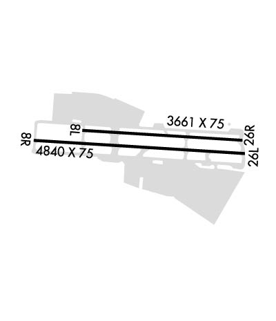
| Lat: N 3405.5 Long: W 11746.9 Elev: 1014 Var: -14 Longest Runway: 4840 | ||
| Clr Del: 121.87 Dept. ATIS: 124.4 Arr. ATIS: 124.4 Ground: 125.0 Tower: 118.2/133.3 | ||
| ||||||||||||||||||||||||||||||||||||||||||||
| ||||||||||||||||||||||||||||||||||||||||||||
| ||||||||||||||||||||||||||||||||||||||||||||
| ||||||||||||||||||||||||||||||||||||||||||||
| ||||||||||||||||||||||||||||||||||||||||||||
| Rwy | Rwy | |||||||
| 3661x75 | 3661' | 3661x75 | 3661' | |||||
| 4840x75 | 4840' | 4840x75 | 4151' | 110.50 - 259° | ||||
| Runway ID | Single Wheel | Double Wheel | Double Tandem Wheel | Dual Double Wheel |
| 08L/26R | 12,500 | N/A | N/A | N/A |
| 08R/26L | 26,000 | N/A | N/A | N/A |
| These numbers are Advisory and are not limits. The Airport Manager should have more accurate Weight Limits | ||||
 Airport Diagram might not be current. | |
| Facility Name: | BRACKETT FLD |
| City Name: | LA VERNE |
| County: | LOS ANGELES |
| State abbrev: | CA |
| State Name: | CALIFORNIA |
| Ownership: | PUBLICLY OWNED |
| Use: | OPEN TO THE PUBLIC |
| Owner's Name: | COUNTY OF LOS ANGELES |
| Address: | PO BOX 1460 |
| ALHAMBRA, CA 91803-1331 | |
| Owner's Phone: | 626-300-4600; LA COUNTY CTC: PAUL MASELBAS, 626-300-4600 X4615. |
| Manager's Name: | JESSEE MALONEY |
| Address: | 1615 MCKINLEY AVENUE |
| LA VERNE, CA 91750 | |
| Phone: | 909-593-1395 |
| FAA Region: | WESTERN-PACIFIC |
| FAA Field Office: | LAX |
| Date | Sunrise | Sunset |
|---|---|---|
| 04/25/24 Thursday | 6:07 | 19:31 |
| 04/26/24 Friday | 6:06 | 19:32 |
| 04/27/24 Saturday | 6:05 | 19:33 |
| 04/28/24 Sunday | 6:04 | 19:33 |
| 04/29/24 Monday | 6:03 | 19:34 |
| 04/30/24 Tuesday | 6:02 | 19:35 |
| 05/01/24 Wednesday | 6:01 | 19:36 |
| 05/02/24 Thursday | 6:00 | 19:37 |
| 05/03/24 Friday | 5:59 | 19:37 |
| 05/04/24 Saturday | 5:58 | 19:38 |
| 05/05/24 Sunday | 5:57 | 19:39 |
| 05/06/24 Monday | 5:56 | 19:40 |
| 05/07/24 Tuesday | 5:55 | 19:40 |
| 05/08/24 Wednesday | 5:54 | 19:41 |
| Airport Attendance Schedule | CONTINUOUS |
| Airport Status | OPERATIONAL (This Status can change at any time - please check NOTAMS) |
| Airport Lighting Schedule | WHEN ATCT CLSD, ARPT LGT OPRS CONSLY FM 2100-0700 LCL. |
| Airport Storage Available | Tie Downs |
| Extra Services Available | Air Ambulance, Avionics, Charter, Flight Instruction, Aircraft Rental, Aircraft Sales, Annual Surveying |
| Wind Indicator | YES - (lighted) |
| Control Tower | YES |
| CTAF Frequency | 118.200 |
| Unicom Frequency | 122.950 |
| Rotating Beacon Color | WG |
| Segmented Circle | YES |
| Landing Fee | NO |
| Airport Inspected | STATE - performed by STATE AERONAUTICAL PERSONNEL |
| Inspection Date | 06/02/2023 |
| Type of Fuel Available | Grade 100LL, JET A (freeze point -40C) |
| Airframe Repair Service | MAJOR |
| Power Plant Repair Service | MAJOR |
| Latitude | N3405.5 |
| Longitude | W11746.9 (ESTIMATED) |
| Arpt Elevation | 1013ft (SURVEYED) |
| Magnetic Variation | 14E |
| 1 miles SW | of LA VERNE |
| Traffic Pattern Altitude | |
| Sectional Chart | LOS ANGELES |
| Operations (Reported) | Yearly | Avg. Daily |
|---|---|---|
| General Aviation Transient | 41116 | 113 |
| General Aviation Local | 65002 | 178 |
| Air Taxi | 176 | 0 |
| Commerical | 21 | 0 |
| Commuter | 0 | 0 |
| Military | 48 | 0 |
| Aircraft based on Field | |
|---|---|
| General Aviation Singles | 81 |
| General Aviation Multi | 6 |
| Jet Aircraft | 1 |
| General Aviation Helicopters | 1 |
| Military Aircraft | 4 |
| Gliders | 1 |
| Ultralights | 0 |
| FSS on field | NO |
| FSS tie-in | RIVERSIDE |
| FSS Phone | 1-800-WX-BRIEF |
| Who issues Notams | POC |
| Notam D service at airport | YES |
| ARTCC Name | LOS ANGELES |
| Airport Certification | |
| Aircraft Rescue & Firefighting Index | None |
| Airport of Entry | No |
| Custom Landing Rights | No |
| Joint Civil/Military | No |
| Military Landing rights | YES |
| NATIONAL PLAN OF INTEGRATED AIRPORT SYSTEMS (NPIAS) |
| GRANT AGREEMENTS UNDER FAAP/ADAP/AIP |
| ASSURANCES PURSUANT TO TITLE VI, CIVIL RIGHTS ACT OF 1964 |
| NOISE ABATEMENT PROCEDURES IN EFFECT CTC AMGR (909) 593-1395. |
| RY 08L/26R UNLGTD. |
| BIRDS AND WILDLIFE IN VICINITY OF AIRPORT. |
| RAPIDLY RISING TERRAIN 1 MILE W-NW OF ARPT. |
| FOR CD WHEN ATCT CLSD CTC SOCAL APCH AT 800-448-3724. |
Airport Communications & Frequencies:
| ||||||||||||||||||||||||||||||||||
| Runway: 08L | Runway: 26R | ||
| Mag heading: | 79° | Mag heading: | 259° |
| Rwy Slope: | .95% Up | Rwy Slope: | -.95% Down |
| Approach: | Approach: | ||
| Pattern: | Left Traffic | Pattern: | Right Traffic |
| Markings: | BASIC | Markings: | BASIC |
| Marking Condition: | GOOD | Marking Condition: | GOOD |
| Arresting Dev: | Arresting Dev: | ||
| Lat & Long: | N3405.5 W11747.2 | Lat. & Long.: | N3405.5 W11746.5 |
| Elev: | 979.1 ft. MSL | Elev: | 1013.9 ft. MSL |
| TCH: | TCH: | ||
| Visual Glide Path: | Visual Glide Path: | ||
| Displaced Threshold: | No | Displaced Threshold: | No |
| Touchdown Zone: | YES | Touchdown Zone: | YES |
| Touchdown Elev.: | 1007.4 feet | Touchdown Elev.: | 1013.9 feet |
| Visual Glide Slope: | Visual Glide Slope: | ||
| RVR Equipment: | RVR Equipment: | ||
| RVV Equipment: | NO | RVV Equipment: | NO |
| Approach Lights: | Approach Lights: | ||
| REIL: | NO | REIL: | NO |
| Centerline Lights: | NO | Centerline Lights: | NO |
| Touchdown lights: | NO | Touchdown lights: | NO |
| Runway Category: | Runway with a Visual Approach | Runway Category: | Runway with a Visual Approach |
| Declared Distances: | Declared Distances: | ||
| Obstructions: | HILL | Obstructions: | ROAD |
| Marked: | NOT Marked/Lighted | Marked: | NOT Marked/Lighted |
| Clearance slope: | 18:1 | Clearance slope: | 22:1 |
| Obstruction height: | 240 feet AGL | Obstruction height: | 15 feet AGL |
| Dist. from runway: | 4750 feet | Dist. from runway: | 540 feet |
| Centerline offset: | 500 left of centerline | Centerline offset: | 159 feet left of centerline |
| Comments: | Comments: |
| Runway: 08R | Runway: 26L | ||
| Mag heading: | 79° | Mag heading: | 259° |
| Rwy Slope: | .95% Up | Rwy Slope: | -.95% Down |
| Approach: | Approach: | ILS | |
| Pattern: | Right Traffic | Pattern: | Left Traffic |
| Markings: | BASIC | Markings: | PRECISION INSTRUMENT |
| Marking Condition: | GOOD | Marking Condition: | GOOD |
| Arresting Dev: | Arresting Dev: | ||
| Lat & Long: | N3405.5 W11747.4 | Lat. & Long.: | N3405.5 W11746.5 |
| Elev: | 965.3 ft. MSL | Elev: | 1011.1 ft. MSL |
| TCH: | 34 ft. AGL | TCH: | 18 ft. AGL |
| Visual Glide Path: | 3.76 degrees | Visual Glide Path: | 3.76 degrees |
| Displaced Threshold: | No | Displaced Threshold: | 689 feet |
| Touchdown Zone: | YES | Touchdown Zone: | YES |
| Touchdown Elev.: | 996.1 feet | Touchdown Elev.: | 1004.6 feet |
| Visual Glide Slope: | 4-Light PAPI on LEFT side of Runway; UNUSBL BYD 5 DEG L OF CNTRLN. | Visual Glide Slope: | 4-Light PAPI on LEFT side of Runway |
| RVR Equipment: | RVR Equipment: | ||
| RVV Equipment: | NO | RVV Equipment: | NO |
| Approach Lights: | Approach Lights: | ||
| REIL: | YES | REIL: | YES |
| Centerline Lights: | NO | Centerline Lights: | NO |
| Touchdown lights: | NO | Touchdown lights: | NO |
| Runway Category: | Runway with a Visual Approach | Runway Category: | Precision Instrument Runway |
| Declared Distances: | Declared Distances: | ||
| Obstructions: | HILL | Obstructions: | ROAD |
| Marked: | NOT Marked/Lighted | Marked: | NOT Marked/Lighted |
| Clearance slope: | 13:1 | Clearance slope: | APCH RATIO TO DSPLCD THR 50:1. APCH RATIO TO DSPLCD THR OVER +65 FT POLES 1988 FT FROM DSPLCD THR, 250 FT L, 30:1. |
| Obstruction height: | 254 feet AGL | Obstruction height: | 15 feet AGL |
| Dist. from runway: | 3651 feet | Dist. from runway: | 200 feet |
| Centerline offset: | 800 left of centerline | Centerline offset: | 290 feet left of centerline |
| Comments: | Comments: |
Thanks for using FltPlan.com
all rights reserved © 1999-2024 by Flight Plan LLC