
| COCHISE COUNTY WILLCOX AZ |
| |
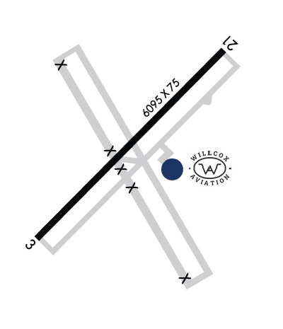
| Lat: N 3214.7 Long: W 10953.7 Elev: 4187 Var: -11 Longest Runway: 6095 | ||
| CTAF: 122.8 | ||
| |||||||||||||||||||||||||||||||||||||||||||||||||||||||||||||||||||||
| |||||||||||||||||||||||||||||||||||||||||||||||||||||||||||||||||||||
| Rwy | Rwy | |||||||
| 6095x75 | 6095' | 6095x75 | 6095' | |||||
| Runway ID | Single Wheel | Double Wheel | Double Tandem Wheel | Dual Double Wheel |
| 03/21 | 50,000 | 75,000 | 135,000 | N/A |
| These numbers are Advisory and are not limits. The Airport Manager should have more accurate Weight Limits | ||||
 Airport Diagram might not be current. | |
| Facility Name: | COCHISE COUNTY |
| City Name: | WILLCOX |
| County: | COCHISE |
| State abbrev: | AZ |
| State Name: | ARIZONA |
| Ownership: | PUBLICLY OWNED |
| Use: | OPEN TO THE PUBLIC |
| Owner's Name: | COCHISE COUNTY |
| Address: | 1415 W MELODY LANE |
| BISBEE, AZ 85603 | |
| Owner's Phone: | 520-432-5471 |
| Manager's Name: | MIKE WEAR |
| Address: | 780 S VISTA AVE |
| WILCOX, AZ 85643 | |
| Phone: | (520) 384-2908 |
| FAA Region: | WESTERN-PACIFIC |
| FAA Field Office: | PHX |
| Date | Sunrise | Sunset |
|---|---|---|
| 04/25/24 Thursday | 5:38 | 18:57 |
| 04/26/24 Friday | 5:37 | 18:58 |
| 04/27/24 Saturday | 5:36 | 18:58 |
| 04/28/24 Sunday | 5:35 | 18:59 |
| 04/29/24 Monday | 5:34 | 19:00 |
| 04/30/24 Tuesday | 5:33 | 19:00 |
| 05/01/24 Wednesday | 5:32 | 19:01 |
| 05/02/24 Thursday | 5:32 | 19:02 |
| 05/03/24 Friday | 5:31 | 19:03 |
| 05/04/24 Saturday | 5:30 | 19:03 |
| 05/05/24 Sunday | 5:29 | 19:04 |
| 05/06/24 Monday | 5:28 | 19:05 |
| 05/07/24 Tuesday | 5:27 | 19:05 |
| 05/08/24 Wednesday | 5:26 | 19:06 |
| Airport Attendance Schedule | 7 Days A Week 0800-1700, CLSD HOLS |
| Airport Status | OPERATIONAL (This Status can change at any time - please check NOTAMS) |
| Airport Lighting Schedule | ACTVT MIRL RWY 03/21 - CTAF. |
| Airport Storage Available | Tie Downs, Hanger |
| Extra Services Available | Flight Instruction, Aircraft Rental |
| Wind Indicator | YES - (lighted) |
| Control Tower | NO |
| CTAF Frequency | 122.800 |
| Unicom Frequency | 122.800 |
| Rotating Beacon Color | WG |
| Segmented Circle | YES |
| Landing Fee | NO |
| Airport Inspected | STATE - performed by PRIVATE CONTRACT PERSONNEL |
| Inspection Date | 04/10/2023 |
| Type of Fuel Available | Grade 100LL, JET A-1 (icing inhibitor, freeze point -50C) |
| Airframe Repair Service | MINOR |
| Power Plant Repair Service | MINOR |
| Latitude | N3214.7 |
| Longitude | W10953.7 (ESTIMATED) |
| Arpt Elevation | 4187ft (SURVEYED) |
| Magnetic Variation | 11E |
| 3 miles W | of WILLCOX |
| Traffic Pattern Altitude | |
| Sectional Chart | PHOENIX |
| Operations (Reported) | Yearly | Avg. Daily |
|---|---|---|
| General Aviation Transient | 7500 | 21 |
| General Aviation Local | 42000 | 115 |
| Air Taxi | 0 | 0 |
| Commerical | 0 | 0 |
| Commuter | 0 | 0 |
| Military | 1000 | 3 |
| Aircraft based on Field | |
|---|---|
| General Aviation Singles | 17 |
| General Aviation Multi | 0 |
| Jet Aircraft | 0 |
| General Aviation Helicopters | 0 |
| Military Aircraft | 0 |
| Gliders | 0 |
| Ultralights | 0 |
| FSS on field | NO |
| FSS tie-in | PRESCOTT |
| FSS Phone | 1-800-WX-BRIEF |
| Who issues Notams | PRC |
| Notam D service at airport | YES |
| ARTCC Name | ALBUQUERQUE |
| Airport Certification | |
| Aircraft Rescue & Firefighting Index | None |
| Airport of Entry | No |
| Custom Landing Rights | No |
| Joint Civil/Military | No |
| Military Landing rights | YES |
| NATIONAL PLAN OF INTEGRATED AIRPORT SYSTEMS (NPIAS) |
| GRANT AGREEMENTS UNDER FAAP/ADAP/AIP |
| ASSURANCES PURSUANT TO TITLE VI, CIVIL RIGHTS ACT OF 1964 |
| AGREEMENT UNDER DLAND OR DCLA HAS EXPIRED. |
| MIL OPS INVOF ARPT. |
| SOUTH HALF OF PARALLEL TWY TO RWY 03 UNUSABLE AND CLOSED. |
| FOR CD CTC ALBUQUERQUE ARTCC AT 505-856-4861. |
| RWY 03/2 1 RWY 21 CALM WIND RWY. |
Airport Communications & Frequencies:
| |||||||||
| Runway: 03 | Runway: 21 | ||
| Mag heading: | 34° | Mag heading: | 214° |
| Rwy Slope: | .06% Up | Rwy Slope: | -.06% Down |
| Approach: | Approach: | ||
| Pattern: | Left Traffic | Pattern: | Left Traffic |
| Markings: | NONPRECISION INSTRUMENT | Markings: | NONPRECISION INSTRUMENT |
| Marking Condition: | GOOD | Marking Condition: | GOOD |
| Arresting Dev: | Arresting Dev: | ||
| Lat & Long: | N3214.4 W10954.1 | Lat. & Long.: | N3215.1 W10953.3 |
| Elev: | 4182.0 ft. MSL | Elev: | 4185.7 ft. MSL |
| TCH: | 42 ft. AGL | TCH: | 43 ft. AGL |
| Visual Glide Path: | 3.00 degrees | Visual Glide Path: | 3.00 degrees |
| Displaced Threshold: | No | Displaced Threshold: | No |
| Touchdown Zone: | YES | Touchdown Zone: | YES |
| Touchdown Elev.: | 4186.4 feet | Touchdown Elev.: | 4187.3 feet |
| Visual Glide Slope: | 4-Light PAPI on LEFT side of Runway | Visual Glide Slope: | 4-Light PAPI on LEFT side of Runway |
| RVR Equipment: | RVR Equipment: | ||
| RVV Equipment: | NO | RVV Equipment: | NO |
| Approach Lights: | Approach Lights: | ||
| REIL: | NO | REIL: | NO |
| Centerline Lights: | NO | Centerline Lights: | NO |
| Touchdown lights: | NO | Touchdown lights: | NO |
| Runway Category: | Runway with a Non-precision Approach | Runway Category: | Runway with a Non-precision Approach |
| Declared Distances: | Declared Distances: |
Thanks for using FltPlan.com
all rights reserved © 1999-2024 by Flight Plan LLC


