
| HOLBROOK MUNI HOLBROOK AZ |
| |
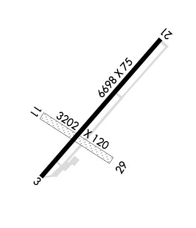
| Lat: N 3456.4 Long: W 11008.3 Elev: 5262 Var: -12 Longest Runway: 6698 | ||
| AWOS: 118.67 CTAF: 122.8 | ||
| ||||||||||||||||||||||||||||||||||||||||||||
| ||||||||||||||||||||||||||||||||||||||||||||
| ||||||||||||||||||||||||||||||||||||||||||||
| Rwy | Rwy | |||||||
| 6698x75 | 5898' | 6698x75 | 6698' | |||||
| 3202x120 | 3202' | 3202x120 | 3202' | |||||
| Runway ID | Single Wheel | Double Wheel | Double Tandem Wheel | Dual Double Wheel |
| 03/21 | 12,000 | N/A | N/A | N/A |
| 11/29 | N/A | N/A | N/A | N/A |
| These numbers are Advisory and are not limits. The Airport Manager should have more accurate Weight Limits | ||||
| FltPlan does not have IFR approach charts available for KP14. |
 Airport Diagram might not be current. | |
| Facility Name: | HOLBROOK MUNI |
| City Name: | HOLBROOK |
| County: | NAVAJO |
| State abbrev: | AZ |
| State Name: | ARIZONA |
| Ownership: | PUBLICLY OWNED |
| Use: | OPEN TO THE PUBLIC |
| Owner's Name: | CITY OF HOLBROOK |
| Address: | P.O. BOX 70 |
| HOLBROOK, AZ 86025 | |
| Owner's Phone: | 928-524-6225 |
| Manager's Name: | TIM KELLY |
| Address: | 465 1ST AVE |
| HOLBROOK, AZ 86025 | |
| Phone: | 928-241-2438 |
| FAA Region: | WESTERN-PACIFIC |
| FAA Field Office: | PHX |
| Date | Sunrise | Sunset |
|---|---|---|
| 04/25/24 Thursday | 5:35 | 19:02 |
| 04/26/24 Friday | 5:34 | 19:03 |
| 04/27/24 Saturday | 5:33 | 19:03 |
| 04/28/24 Sunday | 5:32 | 19:04 |
| 04/29/24 Monday | 5:31 | 19:05 |
| 04/30/24 Tuesday | 5:30 | 19:06 |
| 05/01/24 Wednesday | 5:29 | 19:07 |
| 05/02/24 Thursday | 5:28 | 19:07 |
| 05/03/24 Friday | 5:27 | 19:08 |
| 05/04/24 Saturday | 5:26 | 19:09 |
| 05/05/24 Sunday | 5:25 | 19:10 |
| 05/06/24 Monday | 5:24 | 19:11 |
| 05/07/24 Tuesday | 5:23 | 19:11 |
| 05/08/24 Wednesday | 5:22 | 19:12 |
| Airport Attendance Schedule | UNATTENDED; FOR ARPT ATTENDANT MON-FRI 0800-1700 CALL 928-241-2438 (SHERIFFS OFFICE) OR 928-524-3991. |
| Airport Status | OPERATIONAL (This Status can change at any time - please check NOTAMS) |
| Airport Lighting Schedule | ACTVT REIL RWY 03 & 21; PAPI RWY 03 & 21; MIRL RWY 03/21 - CTAF. |
| Airport Storage Available | Tie Downs, Hanger |
| Extra Services Available | NONE |
| Wind Indicator | YES - (lighted) |
| Control Tower | NO |
| CTAF Frequency | 122.800 |
| Unicom Frequency | 122.800 |
| Rotating Beacon Color | WG |
| Segmented Circle | NO |
| Landing Fee | NO |
| Airport Inspected | STATE - performed by PRIVATE CONTRACT PERSONNEL |
| Inspection Date | 04/09/2021 |
| Type of Fuel Available | Grade 100LL; -10SELF SERVICE FUEL AVAILABLE 24 HRS WITH MAJOR CREDIT CARD. |
| Airframe Repair Service | NONE |
| Power Plant Repair Service | NONE |
| Latitude | N3456.4 |
| Longitude | W11008.3 (ESTIMATED) |
| Arpt Elevation | 5261ft (SURVEYED) |
| Magnetic Variation | 12E |
| 3 miles NE | of HOLBROOK |
| Traffic Pattern Altitude | |
| Sectional Chart | PHOENIX |
| Operations (Reported) | Yearly | Avg. Daily |
|---|---|---|
| General Aviation Transient | 3000 | 8 |
| General Aviation Local | 700 | 2 |
| Air Taxi | 0 | 0 |
| Commerical | 0 | 0 |
| Commuter | 0 | 0 |
| Military | 0 | 0 |
| Aircraft based on Field | |
|---|---|
| General Aviation Singles | 9 |
| General Aviation Multi | 0 |
| Jet Aircraft | 0 |
| General Aviation Helicopters | 0 |
| Military Aircraft | 0 |
| Gliders | 0 |
| Ultralights | 0 |
| FSS on field | NO |
| FSS tie-in | PRESCOTT |
| FSS Phone | 1-800-WX-BRIEF |
| Who issues Notams | PRC |
| Notam D service at airport | YES |
| ARTCC Name | ALBUQUERQUE |
| Airport Certification | |
| Aircraft Rescue & Firefighting Index | None |
| Airport of Entry | No |
| Custom Landing Rights | No |
| Joint Civil/Military | No |
| Military Landing rights | YES |
| NATIONAL PLAN OF INTEGRATED AIRPORT SYSTEMS (NPIAS) |
| GRANT AGREEMENTS UNDER FAAP/ADAP/AIP |
| ASSURANCES PURSUANT TO TITLE VI, CIVIL RIGHTS ACT OF 1964 |
| WILDLIFE ON OR IN VICINITY OF AIRPORT. |
| HELIPAD MARKED ON SOUTH END OF AIRCRAFT RAMP. |
| RWY 11/2 9 RWY ROUGH RUTTED. |
| RWY 11/2 9 1SOFT DIRT RWY, FOR SURFACE CONDITION CALL 928-241-2438. |
Airport Communications & Frequencies:
| |||||||||
| Runway: 03 | Runway: 21 | ||
| Mag heading: | N/A | Mag heading: | N/A |
| Rwy Slope: | .41% Up | Rwy Slope: | -.41% Down |
| Approach: | Approach: | ||
| Pattern: | Left Traffic | Pattern: | Left Traffic |
| Markings: | NONPRECISION INSTRUMENT | Markings: | NONPRECISION INSTRUMENT |
| Marking Condition: | GOOD | Marking Condition: | GOOD |
| Arresting Dev: | Arresting Dev: | ||
| Lat & Long: | N3456.1 W11008.7 | Lat. & Long.: | N3456.9 W11007.8 |
| Elev: | 5234.3 ft. MSL | Elev: | 5261.8 ft. MSL |
| TCH: | TCH: | ||
| Visual Glide Path: | 3.00 degrees | Visual Glide Path: | 3.00 degrees |
| Displaced Threshold: | 800 feet | Displaced Threshold: | No |
| Touchdown Zone: | YES | Touchdown Zone: | YES |
| Touchdown Elev.: | 5239.7 feet | Touchdown Elev.: | 5261.8 feet |
| Visual Glide Slope: | 2-Light PAPI on LEFT side of Runway | Visual Glide Slope: | 2-Light PAPI on LEFT side of Runway |
| RVR Equipment: | RVR Equipment: | ||
| RVV Equipment: | NO | RVV Equipment: | NO |
| Approach Lights: | Approach Lights: | ||
| REIL: | YES | REIL: | YES |
| Centerline Lights: | NO | Centerline Lights: | NO |
| Touchdown lights: | NO | Touchdown lights: | NO |
| Runway Category: | Runway with a Visual Approach | Runway Category: | Runway with a Visual Approach |
| Declared Distances: | Declared Distances: | ||
| Obstructions: | ROAD | Obstructions: | |
| Marked: | NOT Marked/Lighted | Marked: | |
| Clearance slope: | 7:1; APCH RATIO 57:1 TO DSPLCD THR. | Clearance slope: | 50:1 |
| Obstruction height: | 15 feet AGL | Obstruction height: | |
| Dist. from runway: | 340 feet | Dist. from runway: | |
| Centerline offset: | 140 left of centerline | Centerline offset: | |
| Comments: | DIRT ROAD 104 FT FM EOR; +1 FT-2 FT BRUSH 0 FT-200FT FROM THRESHOLD, ACROSS APPROACH AREA. | Comments: | +1 FT TO 3 FT BRUSH 0FT TO 200 FT FM THLD ACROSS APCH AREA. |
| Runway: 11 | Runway: 29 | ||
| Mag heading: | N/A | Mag heading: | N/A |
| Rwy Slope: | .36% Up | Rwy Slope: | -.36% Down |
| Approach: | Approach: | ||
| Pattern: | Left Traffic | Pattern: | Left Traffic |
| Markings: | NONE | Markings: | NONE |
| Marking Condition: | Marking Condition: | ||
| Arresting Dev: | Arresting Dev: | ||
| Lat & Long: | N3456.4 W11008.7 | Lat. & Long.: | N3456.2 W11008.1 |
| Elev: | 5238.3 ft. MSL | Elev: | 5249.8 ft. MSL |
| TCH: | TCH: | ||
| Visual Glide Path: | Visual Glide Path: | ||
| Displaced Threshold: | No | Displaced Threshold: | No |
| Touchdown Zone: | YES | Touchdown Zone: | YES |
| Touchdown Elev.: | 5245.3 feet | Touchdown Elev.: | 5249.8 feet |
| Visual Glide Slope: | Visual Glide Slope: | ||
| RVR Equipment: | RVR Equipment: | ||
| RVV Equipment: | NO | RVV Equipment: | NO |
| Approach Lights: | Approach Lights: | ||
| REIL: | NO | REIL: | NO |
| Centerline Lights: | NO | Centerline Lights: | NO |
| Touchdown lights: | NO | Touchdown lights: | NO |
| Runway Category: | Runway with a Visual Approach | Runway Category: | Runway with a Visual Approach |
| Declared Distances: | Declared Distances: | ||
| Obstructions: | ROAD | Obstructions: | POLE |
| Marked: | NOT Marked/Lighted | Marked: | NOT Marked/Lighted |
| Clearance slope: | Clearance slope: | 10:1 | |
| Obstruction height: | 10 feet AGL | Obstruction height: | 40 feet AGL |
| Dist. from runway: | 0 feet | Dist. from runway: | 400 feet |
| Centerline offset: | Centerline offset: | 10 feet left of centerline | |
| Comments: | Comments: |
Thanks for using FltPlan.com
all rights reserved © 1999-2024 by Flight Plan LLC
