
| MIAMI UNIVERSITY OXFORD OH |
| |
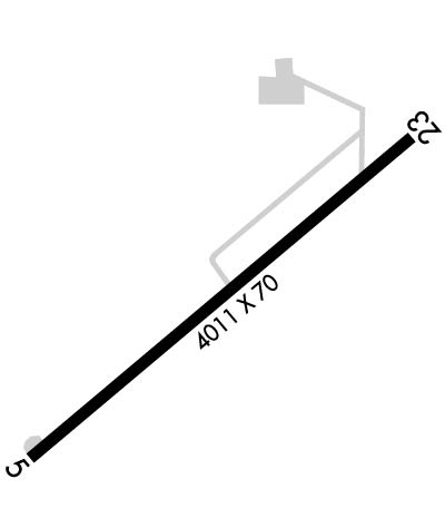
| Lat: N 3930.1 Long: W 08447.1 Elev: 1041 Var: +04 Longest Runway: 4011 | ||
| AWOS: 118.62 CTAF: 122.8 | ||
| ||||||||||||||||||||||||||||||||||||||||||||
| ||||||||||||||||||||||||||||||||||||||||||||
| ||||||||||||||||||||||||||||||||||||||||||||
| Rwy | Rwy | |||||||
| 4011x70 | 3741' | 4011x70 | 4011' | |||||
| Runway ID | Single Wheel | Double Wheel | Double Tandem Wheel | Dual Double Wheel |
| 05/23 | 34,000 | 50,000 | N/A | N/A |
| These numbers are Advisory and are not limits. The Airport Manager should have more accurate Weight Limits | ||||
 Airport Diagram might not be current. | |
| Facility Name: | MIAMI UNIVERSITY |
| City Name: | OXFORD |
| County: | BUTLER |
| State abbrev: | OH |
| State Name: | OHIO |
| Ownership: | PUBLICLY OWNED |
| Use: | OPEN TO THE PUBLIC |
| Owner's Name: | MIAMI UNIVERSITY |
| Address: | MIAMI UNIVERSITY ARPT, 101 S FISHER DR |
| OXFORD, OH 45056-3609 | |
| Owner's Phone: | 513-529-3621 |
| Manager's Name: | ROB ESCHENBRENNER |
| Address: | 7101 FAIRFIELD RD |
| OXFORD, OH 45056-9776 | |
| Phone: | 513-529-2735; CELL 859-322-2129. |
| FAA Region: | GREAT LAKES |
| FAA Field Office: | DET |
| Date | Sunrise | Sunset |
|---|---|---|
| 04/25/24 Thursday | 6:47 | 20:28 |
| 04/26/24 Friday | 6:46 | 20:29 |
| 04/27/24 Saturday | 6:44 | 20:30 |
| 04/28/24 Sunday | 6:43 | 20:31 |
| 04/29/24 Monday | 6:42 | 20:32 |
| 04/30/24 Tuesday | 6:40 | 20:33 |
| 05/01/24 Wednesday | 6:39 | 20:34 |
| 05/02/24 Thursday | 6:38 | 20:35 |
| 05/03/24 Friday | 6:37 | 20:36 |
| 05/04/24 Saturday | 6:36 | 20:37 |
| 05/05/24 Sunday | 6:35 | 20:38 |
| 05/06/24 Monday | 6:33 | 20:39 |
| 05/07/24 Tuesday | 6:32 | 20:40 |
| 05/08/24 Wednesday | 6:31 | 20:40 |
| Airport Attendance Schedule | MON-FRI 0800-1600, SAT-SUN ON CALL; FOR SVC WKENDS & AFT HRS CALL 859-767-7777. UNATNDD MAJOR HOLS. |
| Airport Status | OPERATIONAL (This Status can change at any time - please check NOTAMS) |
| Airport Lighting Schedule | ACTVT OR INCR INTST REIL RWY 05 & 23; MIRL RWY 05/23 - 122.9. PAPI RWY 05 & 23 OPR CONSLY; MIRL RWY 05/23 PRESET LOW INTST DUSK-2100. |
| Airport Storage Available | Tie Downs, Hanger |
| Extra Services Available | Flight Instruction |
| Wind Indicator | YES - (lighted) |
| Control Tower | NO |
| CTAF Frequency | 122.800 |
| Unicom Frequency | 122.800 |
| Rotating Beacon Color | WG |
| Segmented Circle | NO |
| Landing Fee | NO |
| Airport Inspected | STATE - performed by STATE AERONAUTICAL PERSONNEL |
| Inspection Date | 09/22/2022 |
| Type of Fuel Available | Grade 100LL, JET A-1 (icing inhibitor, freeze point -50C); -10FUEL AVBL H24 SELF SVC VIA CREDIT CARD. |
| Airframe Repair Service | NONE |
| Power Plant Repair Service | NONE |
| Latitude | N3930.1 |
| Longitude | W08447.1 (ESTIMATED) |
| Arpt Elevation | 1040ft (SURVEYED) |
| Magnetic Variation | 04W |
| 2 miles W | of OXFORD |
| Traffic Pattern Altitude | |
| Sectional Chart | CINCINNATI |
| Operations (Reported) | Yearly | Avg. Daily |
|---|---|---|
| General Aviation Transient | 2600 | 7 |
| General Aviation Local | 14610 | 40 |
| Air Taxi | 104 | 0 |
| Commerical | 0 | 0 |
| Commuter | 0 | 0 |
| Military | 2 | 0 |
| Aircraft based on Field | |
|---|---|
| General Aviation Singles | 15 |
| General Aviation Multi | 3 |
| Jet Aircraft | 0 |
| General Aviation Helicopters | 0 |
| Military Aircraft | 0 |
| Gliders | 0 |
| Ultralights | 0 |
| FSS on field | NO |
| FSS tie-in | DAYTON |
| FSS Phone | 1-800-WX-BRIEF |
| Who issues Notams | DAY |
| Notam D service at airport | YES |
| ARTCC Name | INDIANAPOLIS |
| Airport Certification | |
| Aircraft Rescue & Firefighting Index | None |
| Airport of Entry | No |
| Custom Landing Rights | No |
| Joint Civil/Military | No |
| Military Landing rights | No |
| NATIONAL PLAN OF INTEGRATED AIRPORT SYSTEMS (NPIAS) |
| FOR CD CTC CINCINNATI APCH AT 859-372-6440. |
Airport Communications & Frequencies:
| ||||||||||||||
| Runway: 05 | Runway: 23 | ||
| Mag heading: | 50° | Mag heading: | 230° |
| Rwy Slope: | -.15% Down | Rwy Slope: | .15% Up |
| Approach: | Approach: | ||
| Pattern: | Left Traffic | Pattern: | Left Traffic |
| Markings: | NONPRECISION INSTRUMENT | Markings: | NONPRECISION INSTRUMENT |
| Marking Condition: | GOOD | Marking Condition: | GOOD |
| Arresting Dev: | Arresting Dev: | ||
| Lat & Long: | N3929.9 W08447.4 | Lat. & Long.: | N3930.4 W08446.8 |
| Elev: | 1040.3 ft. MSL | Elev: | 1034.3 ft. MSL |
| TCH: | 26 ft. AGL | TCH: | 28 ft. AGL |
| Visual Glide Path: | 3.00 degrees | Visual Glide Path: | 3.00 degrees |
| Displaced Threshold: | 270 feet | Displaced Threshold: | No |
| Touchdown Zone: | YES | Touchdown Zone: | YES |
| Touchdown Elev.: | 1040.7 feet | Touchdown Elev.: | 1040.7 feet |
| Visual Glide Slope: | 2-Light PAPI on LEFT side of Runway | Visual Glide Slope: | 2-Light PAPI on LEFT side of Runway |
| RVR Equipment: | RVR Equipment: | ||
| RVV Equipment: | NO | RVV Equipment: | NO |
| Approach Lights: | Approach Lights: | ||
| REIL: | YES | REIL: | YES |
| Centerline Lights: | NO | Centerline Lights: | NO |
| Touchdown lights: | NO | Touchdown lights: | NO |
| Runway Category: | Runway with a Non-precision Approach | Runway Category: | Runway with a Non-precision Approach |
| Declared Distances: | Declared Distances: | ||
| Obstructions: | ROAD | Obstructions: | TREES |
| Marked: | NOT Marked/Lighted | Marked: | NOT Marked/Lighted |
| Clearance slope: | 1:1; APCH SLP 20:1 TO DTHR OVR 59 FT TREE, 1215 FT DIST, 227 FT R. | Clearance slope: | 15:1 |
| Obstruction height: | 10 feet AGL | Obstruction height: | 35 feet AGL |
| Dist. from runway: | 201 feet | Dist. from runway: | 728 feet |
| Centerline offset: | 130 left of centerline | Centerline offset: | 130 feet left of centerline |
| Comments: | 5 FT FENCE & 10 FT ROAD, 75-200 FT DIST, 130-250 FT L. | Comments: |
Thanks for using FltPlan.com
all rights reserved © 1999-2024 by Flight Plan LLC
