
| ONTARIO MUNI ONTARIO OR |
| |
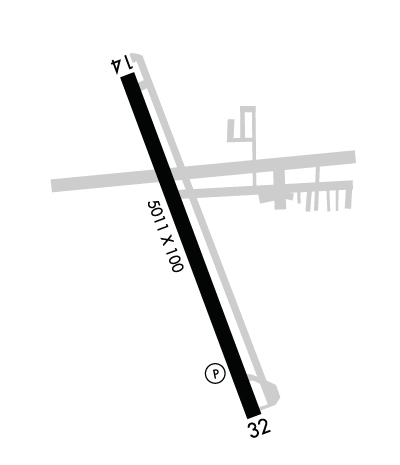
| Lat: N 4401.2 Long: W 11700.8 Elev: 2193 Var: -13 Longest Runway: 5006 | ||
| AWOS: 135.27 CTAF: 122.8 | ||
| ||||||
| ||||||
|
| Rwy | Rwy | |||||||
| 5006x100 | 5006' | 5006x100 | 5006' | |||||
| Runway ID | Single Wheel | Double Wheel | Double Tandem Wheel | Dual Double Wheel |
| 15/33 | 30,000 | 60,000 | N/A | N/A |
| These numbers are Advisory and are not limits. The Airport Manager should have more accurate Weight Limits | ||||
 Airport Diagram might not be current. | |
| Facility Name: | ONTARIO MUNI |
| City Name: | ONTARIO |
| County: | MALHEUR |
| State abbrev: | OR |
| State Name: | OREGON |
| Ownership: | PUBLICLY OWNED |
| Use: | OPEN TO THE PUBLIC |
| Owner's Name: | CITY OF ONTARIO |
| Address: | 444 SW 4TH ST |
| ONTARIO, OR 97914 | |
| Owner's Phone: | 541-889-7684 |
| Manager's Name: | ANDY WOOD |
| Address: | 581 SW 33RD ST. |
| ONTARIO, OR 97914 | |
| Phone: | 541-709-7651; 541-709-7651 CELL. |
| FAA Region: | NORTHWEST MOUNTAIN |
| FAA Field Office: | SEA |
| Date | Sunrise | Sunset |
|---|---|---|
| 05/07/24 Tuesday | 6:30 | 20:59 |
| 05/08/24 Wednesday | 6:29 | 21:01 |
| 05/09/24 Thursday | 6:28 | 21:02 |
| 05/10/24 Friday | 6:27 | 21:03 |
| 05/11/24 Saturday | 6:25 | 21:04 |
| 05/12/24 Sunday | 6:24 | 21:05 |
| 05/13/24 Monday | 6:23 | 21:06 |
| 05/14/24 Tuesday | 6:22 | 21:07 |
| 05/15/24 Wednesday | 6:21 | 21:08 |
| 05/16/24 Thursday | 6:20 | 21:10 |
| 05/17/24 Friday | 6:19 | 21:11 |
| 05/18/24 Saturday | 6:18 | 21:12 |
| 05/19/24 Sunday | 6:17 | 21:13 |
| 05/20/24 Monday | 6:16 | 21:14 |
| Airport Attendance Schedule | 7 Days A Week 0800-1700 |
| Airport Status | OPERATIONAL (This Status can change at any time - please check NOTAMS) |
| Airport Lighting Schedule | ACTVT REIL RWY 15 & 33; MIRL RWY 15/33 - CTAF. PAPI RWY 15 & 33 OPER CONT. |
| Airport Storage Available | Tie Downs |
| Extra Services Available | Crop Dusting, Air Ambulance, Glider, Flight Instruction, Aircraft Rental, Glider Towing |
| Wind Indicator | YES - (lighted) |
| Control Tower | NO |
| CTAF Frequency | 122.800 |
| Unicom Frequency | 122.800 |
| Rotating Beacon Color | WG |
| Segmented Circle | NO |
| Landing Fee | NO |
| Airport Inspected | STATE - performed by STATE AERONAUTICAL PERSONNEL |
| Inspection Date | 03/30/2022 |
| Type of Fuel Available | Grade 100LL, JET A (freeze point -40C); -10SELF SERVE CARD LOCK FUEL AVAIL. 24 HRS. |
| Airframe Repair Service | MAJOR |
| Power Plant Repair Service | MAJOR |
| Latitude | N4401.2 |
| Longitude | W11700.8 (ESTIMATED) |
| Arpt Elevation | 2193ft (SURVEYED) |
| Magnetic Variation | 13E |
| 3 miles W | of ONTARIO |
| Traffic Pattern Altitude | |
| Sectional Chart | KLAMATH FALLS |
| Operations (Reported) | Yearly | Avg. Daily |
|---|---|---|
| General Aviation Transient | 8080 | 22 |
| General Aviation Local | 4850 | 13 |
| Air Taxi | 0 | 0 |
| Commerical | 0 | 0 |
| Commuter | 0 | 0 |
| Military | 0 | 0 |
| Aircraft based on Field | |
|---|---|
| General Aviation Singles | 82 |
| General Aviation Multi | 2 |
| Jet Aircraft | 1 |
| General Aviation Helicopters | 5 |
| Military Aircraft | 0 |
| Gliders | 3 |
| Ultralights | 0 |
| FSS on field | NO |
| FSS tie-in | MC MINNVILLE |
| FSS Phone | 1-800-WX-BRIEF |
| Who issues Notams | ONO |
| Notam D service at airport | YES |
| ARTCC Name | SALT LAKE CITY |
| Airport Certification | |
| Aircraft Rescue & Firefighting Index | None |
| Airport of Entry | No |
| Custom Landing Rights | No |
| Joint Civil/Military | No |
| Military Landing rights | YES |
| NATIONAL PLAN OF INTEGRATED AIRPORT SYSTEMS (NPIAS) |
| GRANT AGREEMENTS UNDER FAAP/ADAP/AIP |
| SURPLUS PROPERTY AGREEMENT UNDER PUBLIC LAW 289 |
| ASSURANCES PURSUANT TO TITLE VI, CIVIL RIGHTS ACT OF 1964 |
| AGREEMENT UNDER DLAND OR DCLA HAS EXPIRED. |
| RWY 15 DESIGNATED AS CALM WINDS RWY |
| GLDR OPS SFC-5000 FT FRI-SAT 11AM-5PM (WX PMTG) MAR-OCT. NOTAMS WILL BE ISSUED WHEN ACTV. GLDRS WILL OPER ON WESTSIDE OF AP & WILL UTILIZE GRASS RWY ADJ TO RWY 15/33 ON WESTSIDE. CALL AMGR AT 541-709-7651 FOR ANY QNS/CONCERNS. |
| FOR CD CTC SALT LAKE ARTCC AT 801-320-2568. |
Airport Communications & Frequencies:
| |||||||||
| Runway: 15 | Runway: 33 | ||
| Mag heading: | 145° | Mag heading: | 325° |
| Rwy Slope: | -.09% Down | Rwy Slope: | .09% Up |
| Approach: | Approach: | ||
| Pattern: | Left Traffic | Pattern: | Left Traffic |
| Markings: | NONPRECISION INSTRUMENT | Markings: | NONPRECISION INSTRUMENT |
| Marking Condition: | GOOD | Marking Condition: | GOOD |
| Arresting Dev: | Arresting Dev: | ||
| Lat & Long: | N4401.5 W11701.0 | Lat. & Long.: | N4400.8 W11700.6 |
| Elev: | 2193.1 ft. MSL | Elev: | 2188.8 ft. MSL |
| TCH: | 40 ft. AGL | TCH: | 40 ft. AGL |
| Visual Glide Path: | 3.00 degrees | Visual Glide Path: | 3.00 degrees |
| Displaced Threshold: | No | Displaced Threshold: | No |
| Touchdown Zone: | YES | Touchdown Zone: | YES |
| Touchdown Elev.: | 2193.3 feet | Touchdown Elev.: | 2193.1 feet |
| Visual Glide Slope: | 2-Light PAPI on LEFT side of Runway | Visual Glide Slope: | 2-Light PAPI on LEFT side of Runway |
| RVR Equipment: | RVR Equipment: | ||
| RVV Equipment: | NO | RVV Equipment: | NO |
| Approach Lights: | Approach Lights: | ||
| REIL: | YES | REIL: | YES |
| Centerline Lights: | NO | Centerline Lights: | NO |
| Touchdown lights: | NO | Touchdown lights: | NO |
| Runway Category: | Runway with a Non-precision Approach having visibility minimums greater than 3/4 mile | Runway Category: | Runway with a Non-precision Approach having visibility minimums greater than 3/4 mile |
| Declared Distances: | Declared Distances: | ||
| Obstructions: | ROAD | Obstructions: | |
| Marked: | NOT Marked/Lighted | Marked: | |
| Clearance slope: | 18:1 | Clearance slope: | 50:1 |
| Obstruction height: | 10 feet AGL | Obstruction height: | |
| Dist. from runway: | 380 feet | Dist. from runway: | |
| Centerline offset: | B | Centerline offset: | |
| Comments: | Comments: |
Thanks for using FltPlan.com
all rights reserved © 1999-2024 by Flight Plan LLC
