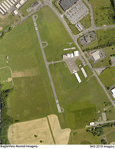
| BRADEN AIRPARK EASTON PA |
| |
| Lat: N 4044.5 Long: W 07514.6 Elev: 397 Var: +13 Longest Runway: 1956 | ||
| CTAF: 123.0 | ||
| |||||||||||||||||||||||||||||||||||||||||||||||||||||||||||||||||||||
| |||||||||||||||||||||||||||||||||||||||||||||||||||||||||||||||||||||
| Rwy | Rwy | |||||||
| 1956x165 | 1764' | 1956x165 | 1956' | |||||
| Runway ID | Single Wheel | Double Wheel | Double Tandem Wheel | Dual Double Wheel |
| 18/36 | N/A | N/A | N/A | N/A |
| These numbers are Advisory and are not limits. The Airport Manager should have more accurate Weight Limits | ||||
 Airport Diagram might not be current. | |
| Facility Name: | BRADEN AIRPARK |
| City Name: | EASTON |
| County: | NORTHAMPTON |
| State abbrev: | PA |
| State Name: | PENNSYLVANIA |
| Ownership: | PUBLICLY OWNED |
| Use: | OPEN TO THE PUBLIC |
| Owner's Name: | LEHIGH-NORTHAMPTON ARPT AUTHORITY |
| Address: | LEHIGH VALLEY INTL ARPT, 3311 AIRPORT ROAD |
| ALLENTOWN, PA 18109-3040 | |
| Owner's Phone: | 610-266-6001 |
| Manager's Name: | THOMAS R. STOUDT |
| Address: | BRADEN AIRPARK, 3800 SULLIVAN TRAIL |
| EASTON, PA 18040 | |
| Phone: | 610-231-5270 |
| FAA Region: | EASTERN |
| FAA Field Office: | HAR |
| Date | Sunrise | Sunset |
|---|---|---|
| 04/25/24 Thursday | 6:07 | 19:52 |
| 04/26/24 Friday | 6:05 | 19:53 |
| 04/27/24 Saturday | 6:04 | 19:54 |
| 04/28/24 Sunday | 6:02 | 19:55 |
| 04/29/24 Monday | 6:01 | 19:56 |
| 04/30/24 Tuesday | 6:00 | 19:57 |
| 05/01/24 Wednesday | 5:59 | 19:58 |
| 05/02/24 Thursday | 5:57 | 19:59 |
| 05/03/24 Friday | 5:56 | 20:00 |
| 05/04/24 Saturday | 5:55 | 20:01 |
| 05/05/24 Sunday | 5:54 | 20:02 |
| 05/06/24 Monday | 5:53 | 20:03 |
| 05/07/24 Tuesday | 5:51 | 20:04 |
| 05/08/24 Wednesday | 5:50 | 20:05 |
| Airport Attendance Schedule | 7 Days A Week 0800-1630 |
| Airport Status | OPERATIONAL (This Status can change at any time - please check NOTAMS) |
| Airport Lighting Schedule | |
| Airport Storage Available | Tie Downs, Hanger |
| Extra Services Available | NONE |
| Wind Indicator | YES - (lighted) |
| Control Tower | NO |
| CTAF Frequency | 123.000 |
| Unicom Frequency | 123.000 |
| Rotating Beacon Color | WG |
| Segmented Circle | NO |
| Landing Fee | NO |
| Airport Inspected | STATE - performed by STATE AERONAUTICAL PERSONNEL |
| Inspection Date | 03/01/2023 |
| Type of Fuel Available | Grade 100LL; -1024 HR SELF-SERVE FUEL AVAILABLE. |
| Airframe Repair Service | MINOR |
| Power Plant Repair Service | MINOR |
| Latitude | N4044.5 |
| Longitude | W07514.6 (ESTIMATED) |
| Arpt Elevation | 396ft (SURVEYED) |
| Magnetic Variation | 13W |
| 3 miles N | of EASTON |
| Traffic Pattern Altitude | |
| Sectional Chart | NEW YORK |
| Operations (Reported) | Yearly | Avg. Daily |
|---|---|---|
| General Aviation Transient | 2900 | 8 |
| General Aviation Local | 6800 | 19 |
| Air Taxi | 135 | 0 |
| Commerical | 0 | 0 |
| Commuter | 0 | 0 |
| Military | 10 | 0 |
| Aircraft based on Field | |
|---|---|
| General Aviation Singles | 27 |
| General Aviation Multi | 1 |
| Jet Aircraft | 0 |
| General Aviation Helicopters | 0 |
| Military Aircraft | 0 |
| Gliders | 0 |
| Ultralights | 0 |
| FSS on field | NO |
| FSS tie-in | WILLIAMSPORT |
| FSS Phone | 1-800-WX-BRIEF |
| Who issues Notams | IPT |
| Notam D service at airport | YES |
| ARTCC Name | NEW YORK |
| Airport Certification | |
| Aircraft Rescue & Firefighting Index | None |
| Airport of Entry | No |
| Custom Landing Rights | No |
| Joint Civil/Military | No |
| Military Landing rights | No |
| THIS AIRPORT HAS BEEN SURVEYED BY THE NATIONAL GEODETIC SURVEY. |
| ACFT MAY NOT BE VISIBLE ON ALL PARTS OF FIELD. |
| FOR CD CTC ALLENTOWN APCH AT 800-728-6322. |
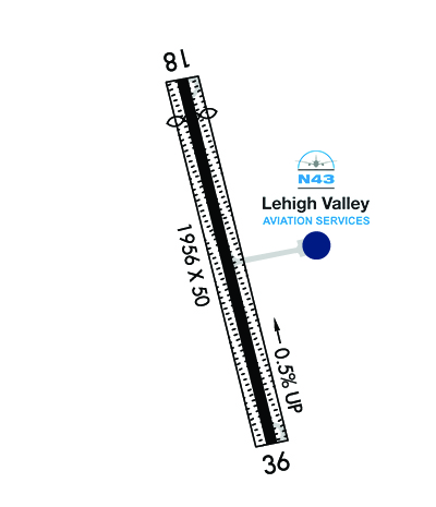
| RWY 18/3 6 RY 18/36 1956 FT BY 50 FT ASPH ALIGNED IN CNTR OF 165 FT TURF STRIP. |
| RWY 18/3 6 RWY 18/36 NSTD LIRL LGTS SPCD AT 400 FT INTERVALS. |
Airport Communications & Frequencies:
| ||||||||||||||||||
| Runway: 18 | Runway: 36 | ||
| Mag heading: | 179° | Mag heading: | 359° |
| Rwy Slope: | -.53% Down | Rwy Slope: | .53% Up |
| Approach: | Approach: | ||
| Pattern: | Left Traffic | Pattern: | Left Traffic |
| Markings: | BASIC | Markings: | NONPRECISION INSTRUMENT |
| Marking Condition: | GOOD | Marking Condition: | GOOD |
| Arresting Dev: | Arresting Dev: | ||
| Lat & Long: | N4044.7 W07514.6 | Lat. & Long.: | N4044.4 W07514.5 |
| Elev: | 394.6 ft. MSL | Elev: | 384.3 ft. MSL |
| TCH: | TCH: | ||
| Visual Glide Path: | Visual Glide Path: | ||
| Displaced Threshold: | 192 feet | Displaced Threshold: | No |
| Touchdown Zone: | YES | Touchdown Zone: | YES |
| Touchdown Elev.: | 396.8 feet | Touchdown Elev.: | 396.8 feet |
| Visual Glide Slope: | Visual Glide Slope: | ||
| RVR Equipment: | RVR Equipment: | ||
| RVV Equipment: | NO | RVV Equipment: | NO |
| Approach Lights: | Approach Lights: | ||
| REIL: | NO | REIL: | NO |
| Centerline Lights: | NO | Centerline Lights: | NO |
| Touchdown lights: | NO | Touchdown lights: | NO |
| Runway Category: | Runway with a Visual Approach | Runway Category: | Runway with a Non-precision Approach |
| Declared Distances: | Declared Distances: | ||
| Obstructions: | TREE | Obstructions: | TREES |
| Marked: | NOT Marked/Lighted | Marked: | NOT Marked/Lighted |
| Clearance slope: | 4:1; APCH RATIO 13:1 TO DTHR. | Clearance slope: | 14:1 |
| Obstruction height: | 46 feet AGL | Obstruction height: | 34 feet AGL |
| Dist. from runway: | 422 feet | Dist. from runway: | 688 feet |
| Centerline offset: | 263 left of centerline | Centerline offset: | 121 feet right of centerline |
| Comments: | Comments: |
Thanks for using FltPlan.com
all rights reserved © 1999-2024 by Flight Plan LLC