
| MONTE VISTA MUNI MONTE VISTA CO |
| |
| Lat: N 3731.7 Long: W 10602.8 Elev: 7611 Var: -08 Longest Runway: 5902 | ||
| CTAF: 122.8 | ||
| ||||||||||||||||||||||||||||||||||||||||||||
| ||||||||||||||||||||||||||||||||||||||||||||
| Rwy | Rwy | |||||||
| 5902x60 | 5902' | 5902x60 | 5902' | |||||
| 2100x50 | 2100' | 2100x50 | 2100' | |||||
| 2300x30 | 2300' | 2300x30 | 2300' | |||||
| Runway ID | Single Wheel | Double Wheel | Double Tandem Wheel | Dual Double Wheel |
| 02/20 | 12,500 | N/A | N/A | N/A |
| 10/28 | N/A | N/A | N/A | N/A |
| 16/34 | N/A | N/A | N/A | N/A |
| These numbers are Advisory and are not limits. The Airport Manager should have more accurate Weight Limits | ||||
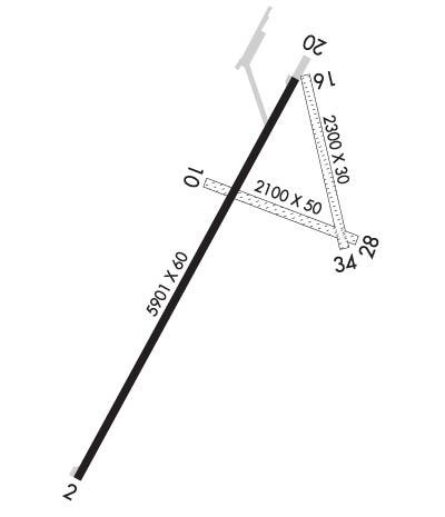 Airport Diagram might not be current. | |
| Facility Name: | MONTE VISTA MUNI |
| City Name: | MONTE VISTA |
| County: | RIO GRANDE |
| State abbrev: | CO |
| State Name: | COLORADO |
| Ownership: | PUBLICLY OWNED |
| Use: | OPEN TO THE PUBLIC |
| Owner's Name: | CITY OF MONTE VISTA |
| Address: | 720 FIRST AVE |
| MONTE VISTA, CO 81144 | |
| Owner's Phone: | 719-852-5926 |
| Manager's Name: | JED ELLITHORP |
| Address: | 5670 E. HWY 160 |
| MONTE VISTA, CO 81144 | |
| Phone: | 719-852-3241 |
| FAA Region: | NORTHWEST MOUNTAIN |
| FAA Field Office: | DEN |
| Date | Sunrise | Sunset |
|---|---|---|
| 04/24/24 Wednesday | 6:16 | 19:49 |
| 04/25/24 Thursday | 6:15 | 19:49 |
| 04/26/24 Friday | 6:14 | 19:50 |
| 04/27/24 Saturday | 6:13 | 19:51 |
| 04/28/24 Sunday | 6:11 | 19:52 |
| 04/29/24 Monday | 6:10 | 19:53 |
| 04/30/24 Tuesday | 6:09 | 19:54 |
| 05/01/24 Wednesday | 6:08 | 19:55 |
| 05/02/24 Thursday | 6:07 | 19:56 |
| 05/03/24 Friday | 6:06 | 19:57 |
| 05/04/24 Saturday | 6:05 | 19:58 |
| 05/05/24 Sunday | 6:04 | 19:59 |
| 05/06/24 Monday | 6:03 | 19:59 |
| 05/07/24 Tuesday | 6:02 | 20:00 |
| Airport Attendance Schedule | MON-FRI 0800-1700, SAT-SUN ON-CALL; SVC AFT HR - AMGR. |
| Airport Status | OPERATIONAL (This Status can change at any time - please check NOTAMS) |
| Airport Lighting Schedule | ACTVT PAPI RWY 02 & 20; MIRL RWY 02/20 - CTAF. |
| Airport Storage Available | Tie Downs, Hanger |
| Extra Services Available | Crop Dusting |
| Wind Indicator | YES - (lighted) |
| Control Tower | NO |
| CTAF Frequency | 122.800 |
| Unicom Frequency | 122.800 |
| Rotating Beacon Color | WG |
| Segmented Circle | YES |
| Landing Fee | NO |
| Airport Inspected | STATE - performed by STATE AERONAUTICAL PERSONNEL |
| Inspection Date | 06/22/2021 |
| Type of Fuel Available | Grade 100LL |
| Airframe Repair Service | MINOR |
| Power Plant Repair Service | MINOR |
| Latitude | N3731.7 |
| Longitude | W10602.8 (ESTIMATED) |
| Arpt Elevation | 7611ft (SURVEYED) |
| Magnetic Variation | 08E |
| 5 miles SE | of MONTE VISTA |
| Traffic Pattern Altitude | |
| Sectional Chart | DENVER |
| Operations (Reported) | Yearly | Avg. Daily |
|---|---|---|
| General Aviation Transient | 2416 | 7 |
| General Aviation Local | 3584 | 10 |
| Air Taxi | 0 | 0 |
| Commerical | 0 | 0 |
| Commuter | 0 | 0 |
| Military | 0 | 0 |
| Aircraft based on Field | |
|---|---|
| General Aviation Singles | 20 |
| General Aviation Multi | 0 |
| Jet Aircraft | 0 |
| General Aviation Helicopters | 0 |
| Military Aircraft | 0 |
| Gliders | 0 |
| Ultralights | 0 |
| FSS on field | NO |
| FSS tie-in | DENVER |
| FSS Phone | 1-800-WX-BRIEF |
| Who issues Notams | DEN |
| Notam D service at airport | YES |
| ARTCC Name | DENVER |
| Airport Certification | |
| Aircraft Rescue & Firefighting Index | None |
| Airport of Entry | No |
| Custom Landing Rights | No |
| Joint Civil/Military | No |
| Military Landing rights | YES |
| NATIONAL PLAN OF INTEGRATED AIRPORT SYSTEMS (NPIAS) |
| GRANT AGREEMENTS UNDER FAAP/ADAP/AIP |
| ASSURANCES PURSUANT TO TITLE VI, CIVIL RIGHTS ACT OF 1964 |
| FOR CD CTC DENVER ARTCC AT 303-651-4257. |
| VEHICLES ON & INVOF ARPT. |
| RWY 02/2 0 SOFT SHOULDERS. |
| RWY 10/2 8 +2 FT DIRT WINDROW ALG N EDGE; VEGETATION THRUT RWY. |
| RWY 16/3 4 +2 FT DIRT WINDROWS & 3+ FT VEGETATION ALG EDGES. |
| RWY 02 4 FT FENCE 280 FT FM RWY END 4 FT BLW RWY END ELEV. |
| RWY 16 +20 FT ANT 700 FT FM THR 215 FT R OF CNTRLN. |
| RWY 20 +23 FT RAILROAD 1110 FT FM THR L & R. |
| RWY 28 +30 FT PWR LINE 534 FT FM THR; +40 FT TREES 345 FT FM THR 230 R OF CNTRLN. |
| RWY 02/2 0 430 FT DIRT SWY ON N END. |
| RWY 10/2 8 EXTREME CROSSWIND USE ONLY. |
| RWY 10/2 8 1SOFT WHEN WET. |
| RWY 16/3 4 SANDY & SOFT. |
Airport Communications & Frequencies:
| |||||||||
| Runway: 02 | Runway: 20 | ||
| Mag heading: | 21° | Mag heading: | 201° |
| Rwy Slope: | -.03% Down | Rwy Slope: | .03% Up |
| Approach: | Approach: | ||
| Pattern: | Left Traffic | Pattern: | Left Traffic |
| Markings: | NONPRECISION INSTRUMENT | Markings: | NONPRECISION INSTRUMENT |
| Marking Condition: | FAIR | Marking Condition: | FAIR |
| Arresting Dev: | Arresting Dev: | ||
| Lat & Long: | N3731.2 W10603.2 | Lat. & Long.: | N3732.1 W10602.6 |
| Elev: | 7611.1 ft. MSL | Elev: | 7609.6 ft. MSL |
| TCH: | 39 ft. AGL | TCH: | 38 ft. AGL |
| Visual Glide Path: | 3.00 degrees | Visual Glide Path: | 3.00 degrees |
| Displaced Threshold: | No | Displaced Threshold: | No |
| Touchdown Zone: | YES | Touchdown Zone: | YES |
| Touchdown Elev.: | 7611.2 feet | Touchdown Elev.: | 7610.3 feet |
| Visual Glide Slope: | 2-Light PAPI on LEFT side of Runway | Visual Glide Slope: | 2-Light PAPI on LEFT side of Runway |
| RVR Equipment: | RVR Equipment: | ||
| RVV Equipment: | NO | RVV Equipment: | NO |
| Approach Lights: | Approach Lights: | ||
| REIL: | NO | REIL: | NO |
| Centerline Lights: | NO | Centerline Lights: | NO |
| Touchdown lights: | NO | Touchdown lights: | NO |
| Runway Category: | Runway with a Visual Approach | Runway Category: | Runway with a Non-precision Approach |
| Declared Distances: | Declared Distances: | ||
| Obstructions: | Obstructions: | PLINE | |
| Marked: | Marked: | NOT Marked/Lighted | |
| Clearance slope: | 50:1 | Clearance slope: | 30:1 |
| Obstruction height: | Obstruction height: | 29 feet AGL | |
| Dist. from runway: | Dist. from runway: | 1085 feet | |
| Centerline offset: | Centerline offset: | 333 feet right of centerline | |
| Comments: | Comments: |
| Runway: 10 | Runway: 28 | ||
| Mag heading: | 103° | Mag heading: | 283° |
| Rwy Slope: | -.10% Down | Rwy Slope: | .10% Up |
| Approach: | Approach: | ||
| Pattern: | Left Traffic | Pattern: | Left Traffic |
| Markings: | NONE | Markings: | NONE |
| Marking Condition: | POOR | Marking Condition: | POOR |
| Arresting Dev: | Arresting Dev: | ||
| Lat & Long: | N3731.8 W10602.8 | Lat. & Long.: | N3731.7 W10602.4 |
| Elev: | 7608.4 ft. MSL | Elev: | 7606.2 ft. MSL |
| TCH: | TCH: | ||
| Visual Glide Path: | Visual Glide Path: | ||
| Displaced Threshold: | No | Displaced Threshold: | No |
| Touchdown Zone: | YES | Touchdown Zone: | YES |
| Touchdown Elev.: | 7609.9 feet | Touchdown Elev.: | 7609.9 feet |
| Visual Glide Slope: | Visual Glide Slope: | ||
| RVR Equipment: | RVR Equipment: | ||
| RVV Equipment: | NO | RVV Equipment: | NO |
| Approach Lights: | Approach Lights: | ||
| REIL: | NO | REIL: | NO |
| Centerline Lights: | NO | Centerline Lights: | NO |
| Touchdown lights: | NO | Touchdown lights: | NO |
| Runway Category: | Runway with a Visual Approach | Runway Category: | Runway with a Visual Approach |
| Declared Distances: | Declared Distances: | ||
| Obstructions: | HAYSTACK | Obstructions: | TREES |
| Marked: | NOT Marked/Lighted | Marked: | NOT Marked/Lighted |
| Clearance slope: | 20:1 | Clearance slope: | 3:1 |
| Obstruction height: | Obstruction height: | 47 feet AGL | |
| Dist. from runway: | Dist. from runway: | 184 feet | |
| Centerline offset: | Centerline offset: | 99 feet left of centerline | |
| Comments: | Comments: |
| Runway: 16 | Runway: 34 | ||
| Mag heading: | 159° | Mag heading: | 339° |
| Rwy Slope: | -.05% Down | Rwy Slope: | .05% Up |
| Approach: | Approach: | ||
| Pattern: | Left Traffic | Pattern: | Left Traffic |
| Markings: | NONE | Markings: | NONE |
| Marking Condition: | POOR | Marking Condition: | POOR |
| Arresting Dev: | Arresting Dev: | ||
| Lat & Long: | N3732.1 W10602.6 | Lat. & Long.: | N3731.7 W10602.5 |
| Elev: | 7607.6 ft. MSL | Elev: | 7606.4 ft. MSL |
| TCH: | TCH: | ||
| Visual Glide Path: | Visual Glide Path: | ||
| Displaced Threshold: | No | Displaced Threshold: | No |
| Touchdown Zone: | YES | Touchdown Zone: | YES |
| Touchdown Elev.: | 7607.6 feet | Touchdown Elev.: | 7607.6 feet |
| Visual Glide Slope: | Visual Glide Slope: | ||
| RVR Equipment: | RVR Equipment: | ||
| RVV Equipment: | NO | RVV Equipment: | NO |
| Approach Lights: | Approach Lights: | ||
| REIL: | NO | REIL: | NO |
| Centerline Lights: | NO | Centerline Lights: | NO |
| Touchdown lights: | NO | Touchdown lights: | NO |
| Runway Category: | Runway with a Visual Approach | Runway Category: | Runway with a Visual Approach |
| Declared Distances: | Declared Distances: | ||
| Obstructions: | Obstructions: | FENCE | |
| Marked: | Marked: | NOT Marked/Lighted | |
| Clearance slope: | 20:1 | Clearance slope: | 27:1 |
| Obstruction height: | Obstruction height: | 8 feet AGL | |
| Dist. from runway: | Dist. from runway: | 218 feet | |
| Centerline offset: | Centerline offset: | B | |
| Comments: | Comments: |
Thanks for using FltPlan.com
all rights reserved © 1999-2024 by Flight Plan LLC
