
| BLUE RIDGE MARTINSVILLE VA |
| |
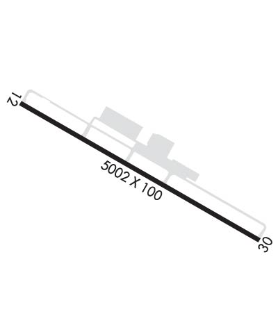
| Lat: N 3637.8 Long: W 08001.1 Elev: 941 Var: +07 Longest Runway: 5002 | ||
| Clr Del: 124.85 AWOS: 118.45 CTAF: 122.7 | ||
| ||||||
| ||||||
|
| Rwy | Rwy | |||||||
| 5002x100 | 5002' | 5002x100 | 5002' | 111.30 - 305° | ||||
| Runway ID | Single Wheel | Double Wheel | Double Tandem Wheel | Dual Double Wheel |
| 13/31 | 30,000 | 60,000 | N/A | N/A |
| These numbers are Advisory and are not limits. The Airport Manager should have more accurate Weight Limits | ||||
 Airport Diagram might not be current. | |
| Facility Name: | BLUE RIDGE |
| City Name: | MARTINSVILLE |
| County: | HENRY |
| State abbrev: | VA |
| State Name: | VIRGINIA |
| Ownership: | PUBLICLY OWNED |
| Use: | OPEN TO THE PUBLIC |
| Owner's Name: | BLUE RIDGE ARPT AUTH |
| Address: | 525 AIRPORT ROAD |
| MARTINSVILLE, VA 24112 | |
| Owner's Phone: | 276-957-2291 |
| Manager's Name: | JASON DAVIS |
| Address: | 525 AIRPORT ROAD |
| MARTINSVILLE, VA 24112 | |
| Phone: | 276-957-2291; MANAGER CELL: 276-358-0749. |
| FAA Region: | EASTERN |
| FAA Field Office: | DCA |
| Date | Sunrise | Sunset |
|---|---|---|
| 04/25/24 Thursday | 6:33 | 20:04 |
| 04/26/24 Friday | 6:31 | 20:05 |
| 04/27/24 Saturday | 6:30 | 20:06 |
| 04/28/24 Sunday | 6:29 | 20:06 |
| 04/29/24 Monday | 6:28 | 20:07 |
| 04/30/24 Tuesday | 6:27 | 20:08 |
| 05/01/24 Wednesday | 6:26 | 20:09 |
| 05/02/24 Thursday | 6:24 | 20:10 |
| 05/03/24 Friday | 6:23 | 20:11 |
| 05/04/24 Saturday | 6:22 | 20:12 |
| 05/05/24 Sunday | 6:21 | 20:13 |
| 05/06/24 Monday | 6:20 | 20:13 |
| 05/07/24 Tuesday | 6:19 | 20:14 |
| 05/08/24 Wednesday | 6:18 | 20:15 |
| Airport Attendance Schedule | 7 Days A Week 0800-1700 |
| Airport Status | OPERATIONAL (This Status can change at any time - please check NOTAMS) |
| Airport Lighting Schedule | ACTVT REIL RWY 13 & 31; ODALS RWY 31; PAPI RWY 13 & 31; MIRL RWY 13/31 - CTAF. |
| Airport Storage Available | Tie Downs |
| Extra Services Available | Charter, Flight Instruction, Aircraft Rental, Aircraft Sales |
| Wind Indicator | YES - (lighted) |
| Control Tower | NO |
| CTAF Frequency | 122.700 |
| Unicom Frequency | 122.700 |
| Rotating Beacon Color | WG |
| Segmented Circle | YES |
| Landing Fee | NO |
| Airport Inspected | STATE - performed by STATE AERONAUTICAL PERSONNEL |
| Inspection Date | 11/20/2020 |
| Type of Fuel Available | Grade 100LL, JET A |
| Airframe Repair Service | MAJOR |
| Power Plant Repair Service | MAJOR |
| Latitude | N3637.8 |
| Longitude | W08001.1 (ESTIMATED) |
| Arpt Elevation | 940ft (SURVEYED) |
| Magnetic Variation | 07W |
| 8 miles SW | of MARTINSVILLE |
| Traffic Pattern Altitude | |
| Sectional Chart | CINCINNATI |
| Operations (Reported) | Yearly | Avg. Daily |
|---|---|---|
| General Aviation Transient | 7163 | 20 |
| General Aviation Local | 15421 | 42 |
| Air Taxi | 699 | 2 |
| Commerical | 0 | 0 |
| Commuter | 0 | 0 |
| Military | 217 | 1 |
| Aircraft based on Field | |
|---|---|
| General Aviation Singles | 16 |
| General Aviation Multi | 3 |
| Jet Aircraft | 1 |
| General Aviation Helicopters | 0 |
| Military Aircraft | 0 |
| Gliders | 0 |
| Ultralights | 0 |
| FSS on field | NO |
| FSS tie-in | LEESBURG |
| FSS Phone | 1-800-WX-BRIEF |
| Who issues Notams | MTV |
| Notam D service at airport | YES |
| ARTCC Name | WASHINGTON |
| Airport Certification | |
| Aircraft Rescue & Firefighting Index | None |
| Airport of Entry | No |
| Custom Landing Rights | No |
| Joint Civil/Military | No |
| Military Landing rights | YES |
| NATIONAL PLAN OF INTEGRATED AIRPORT SYSTEMS (NPIAS) |
| GRANT AGREEMENTS UNDER FAAP/ADAP/AIP |
| ASSURANCES PURSUANT TO TITLE VI, CIVIL RIGHTS ACT OF 1964 |
| DEER ON AND INVOF ARPT. |
| FOR CD CTC GREENSBORO APCH AT 743-222-6129. |
| COLD TEMPERATURE AIRPORT. ALTITUDE CORRECTION REQUIRED AT OR BELOW -17C. |
Airport Communications & Frequencies:
| ||||||||||||||||
| Runway: 13 | Runway: 31 | ||
| Mag heading: | 125° | Mag heading: | 305° |
| Rwy Slope: | -.58% Down | Rwy Slope: | .58% Up |
| Approach: | Approach: | LOC/DME | |
| Pattern: | Left Traffic | Pattern: | Left Traffic |
| Markings: | NONPRECISION INSTRUMENT | Markings: | NONPRECISION INSTRUMENT |
| Marking Condition: | GOOD | Marking Condition: | GOOD |
| Arresting Dev: | Arresting Dev: | ||
| Lat & Long: | N3638.0 W08001.6 | Lat. & Long.: | N3637.7 W08000.6 |
| Elev: | 940.9 ft. MSL | Elev: | 911.9 ft. MSL |
| TCH: | 40 ft. AGL | TCH: | 47 ft. AGL |
| Visual Glide Path: | 3.00 degrees | Visual Glide Path: | 3.00 degrees |
| Displaced Threshold: | No | Displaced Threshold: | No |
| Touchdown Zone: | YES | Touchdown Zone: | YES |
| Touchdown Elev.: | 940.9 feet | Touchdown Elev.: | 925.1 feet |
| Visual Glide Slope: | 4-Light PAPI on LEFT side of Runway; UNUSBL BYD 9 DEG RIGHT OF CNTRLN. | Visual Glide Slope: | 4-Light PAPI on LEFT side of Runway |
| RVR Equipment: | RVR Equipment: | ||
| RVV Equipment: | NO | RVV Equipment: | NO |
| Approach Lights: | Approach Lights: | ODALS - omnidirectional approach lighting system | |
| REIL: | YES | REIL: | YES |
| Centerline Lights: | NO | Centerline Lights: | NO |
| Touchdown lights: | NO | Touchdown lights: | NO |
| Runway Category: | Runway with a Non-precision Approach having visibility minimums greater than 3/4 mile | Runway Category: | Runway with a Non-precision Approach having visibility minimums greater than 3/4 mile |
| Declared Distances: | Declared Distances: | ||
| Obstructions: | TREE | Obstructions: | TREE |
| Marked: | MARKED and LIGHTED | Marked: | NOT Marked/Lighted |
| Clearance slope: | 33:1 | Clearance slope: | 36:1 |
| Obstruction height: | 97 feet AGL | Obstruction height: | 25 feet AGL |
| Dist. from runway: | 3494 feet | Dist. from runway: | 1104 feet |
| Centerline offset: | 639 left of centerline | Centerline offset: | 297 feet right of centerline |
| Comments: | Comments: |
Thanks for using FltPlan.com
all rights reserved © 1999-2024 by Flight Plan LLC
