NOTICE: Information listed below may not be current.Airport Ident: MMQT
| Airport Name: QUERETARO INTERCONTINENTAL, Mexico
Latitude: N2037.0 Longitude: W10011.1
Field Elevation: 6296' Variation: E6° as of 01/06
Time Zone: UTC-6(-5DT)
Daylight Savings: First Sunday in April to the last Saturday in October
Customs: N/A
|
|
| DISTANCE from: | KTEB to MMQT = 1800 nm
| KMIA to MMQT = 1139 nm
| KORD to MMQT = 1424 nm
| KDAL to MMQT = 755 nm
| KSEA to MMQT = 1935 nm
| KLAX to MMQT = 1255 nm
|
|
| AIRPORT TYPE: | | Active civil airports controlled and operated by civil authorities primarily for use by civil aircraft, although military may have landing privileges and/or contract rights. Minimum facilities are available which include: control tower (or some similar control system, such as a Flight Service Station which issues clearances and advisories when there is no tower or the tower is not in operation), lighting (may be flare pots, etc.), petrol, oils and lubricants (POL), and facilities for organizational maintenance or better. |
|
Rotating Beacon: NO
|
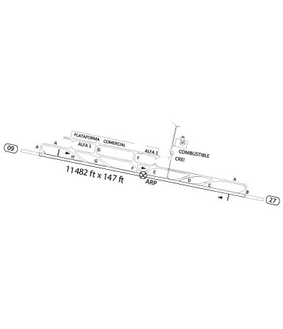
| RUNWAY INFORMATION: | Runway Ident: 27 /09
Runway Length: 11483
Runway Width: 148
Runway Surface: CONCRETE.
Runway PCN Rating: -
Runway PCN Evaluation Method: N/A
Runway Open: YES
| Runway 27 Information
Runway True Heading: 280.8°
Takeoff Distance Available: 12618
Landing Distance Available: 11483
Runway Latitude: N2036.9
Runway Longitude: W10010.2
Runway Elevation:
Runway Slope: N/A
Runway TDZE:
Runway Lighting: HIRL, PAPI
| Runway 09 Information
Runway True Heading: 100.8°
Takeoff Distance Available: 12618
Landing Distance Available: 11483
Runway Latitude: N2037.2
Runway Longitude: W10012.1
Runway Elevation:
Runway Slope: N/A
Runway TDZE: N/A
Runway Lighting: HIRL, PAPI
|
|
|
COMMUNICATION INFORMATION
TOWER - TWR
118.95
|
AIRPORT NAVAIDS
QET - QUERETARO (VOR-DME) - ON FIELD
|