
| SHAFTER-MINTER FIELD SHAFTER CA |
| |
| Lat: N 3530.4 Long: W 11911.5 Elev: 425 Var: -13 Longest Runway: 4501 | ||
| AWOS: 121.12 CTAF: 122.9 | ||
| ||||||
| ||||||
|
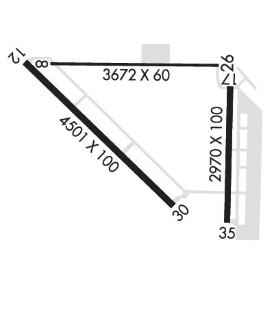
| Rwy | Rwy | |||||||
| 3680x60 | 3540' | 3680x60 | 3514' | |||||
| 4501x100 | 4501' | 4501x100 | 4501' | |||||
| 2972x100 | 2972' | 2972x100 | 2972' | |||||
| Runway ID | Single Wheel | Double Wheel | Double Tandem Wheel | Dual Double Wheel |
| 08/26 | 125,000 | N/A | N/A | N/A |
| 12/30 | 22,000 | N/A | N/A | N/A |
| 17/35 | 25,000 | 30,000 | N/A | N/A |
| These numbers are Advisory and are not limits. The Airport Manager should have more accurate Weight Limits | ||||
 Airport Diagram might not be current. | |
| Facility Name: | SHAFTER-MINTER FLD |
| City Name: | SHAFTER |
| County: | KERN |
| State abbrev: | CA |
| State Name: | CALIFORNIA |
| Ownership: | PUBLICLY OWNED |
| Use: | OPEN TO THE PUBLIC |
| Owner's Name: | MINTER FIELD AIRPORT DISTRICT |
| Address: | 201 AVIATION ST |
| SHAFTER, CA 93263 | |
| Owner's Phone: | 661-393-0402; AFTER HOURS 661-303-6996 |
| Manager's Name: | JONATHAN HUDSON |
| Address: | 201 AVIATION ST |
| SHAFTER, CA 93263 | |
| Phone: | (661) 303-6996 |
| FAA Region: | WESTERN-PACIFIC |
| FAA Field Office: | LAX |
| Date | Sunrise | Sunset |
|---|---|---|
| 04/25/24 Thursday | 6:11 | 19:39 |
| 04/26/24 Friday | 6:10 | 19:40 |
| 04/27/24 Saturday | 6:09 | 19:41 |
| 04/28/24 Sunday | 6:07 | 19:41 |
| 04/29/24 Monday | 6:06 | 19:42 |
| 04/30/24 Tuesday | 6:05 | 19:43 |
| 05/01/24 Wednesday | 6:04 | 19:44 |
| 05/02/24 Thursday | 6:03 | 19:45 |
| 05/03/24 Friday | 6:02 | 19:46 |
| 05/04/24 Saturday | 6:01 | 19:46 |
| 05/05/24 Sunday | 6:00 | 19:47 |
| 05/06/24 Monday | 5:59 | 19:48 |
| 05/07/24 Tuesday | 5:58 | 19:49 |
| 05/08/24 Wednesday | 5:57 | 19:50 |
| Airport Attendance Schedule | MON-FRI 0800-1700 |
| Airport Status | OPERATIONAL (This Status can change at any time - please check NOTAMS) |
| Airport Lighting Schedule | ACTVT REIL RWY 12 & 30; PAPI RWY 30; MIRL RWY 12/30 - CTAF. |
| Airport Storage Available | Tie Downs |
| Extra Services Available | Crop Dusting, Flight Instruction |
| Wind Indicator | YES - (lighted) |
| Control Tower | NO |
| CTAF Frequency | 122.900 |
| Unicom Frequency | |
| Rotating Beacon Color | WG |
| Segmented Circle | YES |
| Landing Fee | NO |
| Airport Inspected | STATE - performed by STATE AERONAUTICAL PERSONNEL |
| Inspection Date | 12/05/2023 |
| Type of Fuel Available | Grade 100LL, JET A (freeze point -40C) |
| Airframe Repair Service | MAJOR |
| Power Plant Repair Service | MAJOR |
| Latitude | N3530.4 |
| Longitude | W11911.5 (ESTIMATED) |
| Arpt Elevation | 424ft (SURVEYED) |
| Magnetic Variation | 13E |
| 4 miles E | of SHAFTER |
| Traffic Pattern Altitude | |
| Sectional Chart | LOS ANGELES |
| Operations (Reported) | Yearly | Avg. Daily |
|---|---|---|
| General Aviation Transient | 25000 | 68 |
| General Aviation Local | 20000 | 55 |
| Air Taxi | 0 | 0 |
| Commerical | 0 | 0 |
| Commuter | 0 | 0 |
| Military | 0 | 0 |
| Aircraft based on Field | |
|---|---|
| General Aviation Singles | 91 |
| General Aviation Multi | 7 |
| Jet Aircraft | 7 |
| General Aviation Helicopters | 2 |
| Military Aircraft | 0 |
| Gliders | 1 |
| Ultralights | 0 |
| FSS on field | NO |
| FSS tie-in | RANCHO MURIETA |
| FSS Phone | 1-800-WX-BRIEF |
| Who issues Notams | RIU |
| Notam D service at airport | YES |
| ARTCC Name | LOS ANGELES |
| Airport Certification | |
| Aircraft Rescue & Firefighting Index | None |
| Airport of Entry | No |
| Custom Landing Rights | No |
| Joint Civil/Military | No |
| Military Landing rights | YES |
| NATIONAL PLAN OF INTEGRATED AIRPORT SYSTEMS (NPIAS) |
| GRANT AGREEMENTS UNDER FAAP/ADAP/AIP |
| SURPLUS PROPERTY AGREEMENT UNDER PUBLIC LAW 289 |
| ASSURANCES PURSUANT TO TITLE VI, CIVIL RIGHTS ACT OF 1964 |
| HEAVY CROP DUSTER ACTIVITY INVOF ARPT. |
| FUEL 24 HR CREDIT CARD SVC AVBL. |
| ULTRALIGHT ACTIVITY ON & INVOF ARPT. |
| RY 30 PREFERRED CALM WIND RY. |
| RYS 26 AND 08 USED EXTENSIVELY BY AERIAL APPLICATOR ACFT. RECOMMEND EXTENSIVE USAGE OF CTAF FOR POSITION REPORTING. |
| FOR CD CTC LOS ANGELES ARTCC AT 661-575-2079. |
Airport Communications & Frequencies:
| |||||||||||||||
| Runway: 08 | Runway: 26 | ||
| Mag heading: | 77° | Mag heading: | 257° |
| Rwy Slope: | .30% Up | Rwy Slope: | -.30% Down |
| Approach: | Approach: | ||
| Pattern: | Left Traffic | Pattern: | Right Traffic |
| Markings: | BASIC | Markings: | BASIC |
| Marking Condition: | GOOD | Marking Condition: | GOOD |
| Arresting Dev: | Arresting Dev: | ||
| Lat & Long: | N3530.6 W11911.9 | Lat. & Long.: | N3530.6 W11911.2 |
| Elev: | 413.7 ft. MSL | Elev: | 424.6 ft. MSL |
| TCH: | TCH: | ||
| Visual Glide Path: | Visual Glide Path: | ||
| Displaced Threshold: | 140 feet | Displaced Threshold: | 166 feet |
| Touchdown Zone: | YES | Touchdown Zone: | YES |
| Touchdown Elev.: | 423.0 feet | Touchdown Elev.: | 424.5 feet |
| Visual Glide Slope: | Visual Glide Slope: | ||
| RVR Equipment: | RVR Equipment: | ||
| RVV Equipment: | NO | RVV Equipment: | NO |
| Approach Lights: | Approach Lights: | ||
| REIL: | NO | REIL: | NO |
| Centerline Lights: | NO | Centerline Lights: | NO |
| Touchdown lights: | NO | Touchdown lights: | NO |
| Runway Category: | Runway with a Visual Approach | Runway Category: | Runway with a Visual Approach |
| Declared Distances: | Declared Distances: | ||
| Obstructions: | TREES | Obstructions: | BLDG |
| Marked: | NOT Marked/Lighted | Marked: | NOT Marked/Lighted |
| Clearance slope: | 28:1; 33:1 TO DSPLCD THLD. | Clearance slope: | 10:1; 28:1 TO THE DSPLCD THLD. |
| Obstruction height: | 60 feet AGL | Obstruction height: | 20 feet AGL |
| Dist. from runway: | 1896 feet | Dist. from runway: | 411 feet |
| Centerline offset: | 190 right of centerline | Centerline offset: | |
| Comments: | Comments: |
| Runway: 12 | Runway: 30 | ||
| Mag heading: | 120° | Mag heading: | 300° |
| Rwy Slope: | -.01% Down | Rwy Slope: | .01% Up |
| Approach: | Approach: | ||
| Pattern: | Right Traffic | Pattern: | Left Traffic |
| Markings: | NONPRECISION INSTRUMENT | Markings: | NONPRECISION INSTRUMENT |
| Marking Condition: | GOOD | Marking Condition: | GOOD |
| Arresting Dev: | Arresting Dev: | ||
| Lat & Long: | N3530.6 W11912.1 | Lat. & Long.: | N3530.1 W11911.4 |
| Elev: | 412.5 ft. MSL | Elev: | 412.2 ft. MSL |
| TCH: | TCH: | 42 ft. AGL | |
| Visual Glide Path: | Visual Glide Path: | 3.00 degrees | |
| Displaced Threshold: | No | Displaced Threshold: | No |
| Touchdown Zone: | YES | Touchdown Zone: | YES |
| Touchdown Elev.: | 412.6 feet | Touchdown Elev.: | 412.3 feet |
| Visual Glide Slope: | Visual Glide Slope: | 4-Light PAPI on LEFT side of Runway | |
| RVR Equipment: | RVR Equipment: | ||
| RVV Equipment: | NO | RVV Equipment: | NO |
| Approach Lights: | Approach Lights: | ||
| REIL: | YES | REIL: | YES |
| Centerline Lights: | NO | Centerline Lights: | NO |
| Touchdown lights: | NO | Touchdown lights: | NO |
| Runway Category: | D | Runway Category: | Runway with a Visual Approach |
| Declared Distances: | Declared Distances: |
| Runway: 17 | Runway: 35 | ||
| Mag heading: | 167° | Mag heading: | 347° |
| Rwy Slope: | -.30% Down | Rwy Slope: | .30% Up |
| Approach: | Approach: | ||
| Pattern: | Right Traffic | Pattern: | Left Traffic |
| Markings: | BASIC | Markings: | BASIC |
| Marking Condition: | GOOD | Marking Condition: | GOOD |
| Arresting Dev: | Arresting Dev: | ||
| Lat & Long: | N3530.6 W11911.2 | Lat. & Long.: | N3530.1 W11911.2 |
| Elev: | 423.1 ft. MSL | Elev: | 414.3 ft. MSL |
| TCH: | TCH: | ||
| Visual Glide Path: | Visual Glide Path: | ||
| Displaced Threshold: | No | Displaced Threshold: | No |
| Touchdown Zone: | YES | Touchdown Zone: | YES |
| Touchdown Elev.: | 423.1 feet | Touchdown Elev.: | 423.1 feet |
| Visual Glide Slope: | Visual Glide Slope: | ||
| RVR Equipment: | RVR Equipment: | ||
| RVV Equipment: | NO | RVV Equipment: | NO |
| Approach Lights: | Approach Lights: | ||
| REIL: | NO | REIL: | NO |
| Centerline Lights: | NO | Centerline Lights: | NO |
| Touchdown lights: | NO | Touchdown lights: | NO |
| Runway Category: | Runway with a Visual Approach | Runway Category: | Runway with a Visual Approach |
| Declared Distances: | Declared Distances: | ||
| Obstructions: | ROAD | Obstructions: | ROAD |
| Marked: | NOT Marked/Lighted | Marked: | NOT Marked/Lighted |
| Clearance slope: | 43:1 | Clearance slope: | 18:1 |
| Obstruction height: | 15 feet AGL | Obstruction height: | 15 feet AGL |
| Dist. from runway: | 850 feet | Dist. from runway: | 470 feet |
| Centerline offset: | 190 left of centerline | Centerline offset: | |
| Comments: | Comments: |
Thanks for using FltPlan.com
all rights reserved © 1999-2024 by Flight Plan LLC
