
| MARSHFIELD MUNI MARSHFIELD WI |
| |
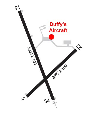
| Lat: N 4438.2 Long: W 09011.4 Elev: 1278 Var: -00 Longest Runway: 5002 | ||
| AWOS: 121.57 CTAF: 123.0 | ||
| |||||||||||||||||||||||||||||||||||||||||||||||||||||||||||||
| |||||||||||||||||||||||||||||||||||||||||||||||||||||||||||||
| |||||||||||||||||||||||||||||||||||||||||||||||||||||||||||||
| Rwy | Rwy | |||||||
| 3597x100 | 3597' | 3597x100 | 3597' | |||||
| 5002x100 | 5002' | 5002x100 | 5002' | 109.90 - 338° | ||||
| Runway ID | Single Wheel | Double Wheel | Double Tandem Wheel | Dual Double Wheel |
| 05/23 | 35,000 | 45,000 | N/A | N/A |
| 16/34 | 35,000 | 50,000 | N/A | N/A |
| These numbers are Advisory and are not limits. The Airport Manager should have more accurate Weight Limits | ||||
 Airport Diagram might not be current. | |
| Facility Name: | MARSHFIELD MUNI |
| City Name: | MARSHFIELD |
| County: | WOOD |
| State abbrev: | WI |
| State Name: | WISCONSIN |
| Ownership: | PUBLICLY OWNED |
| Use: | OPEN TO THE PUBLIC |
| Owner's Name: | CITY OF MARSHFIELD |
| Address: | P.O. BOX 727 |
| MARSHFIELD, WI 54449-0727 | |
| Owner's Phone: | 715-384-2919 |
| Manager's Name: | JEFF GAIER |
| Address: | 400 W 29TH ST |
| MARSHFIELD, WI 54449 | |
| Phone: | 715-387-2211 |
| FAA Region: | GREAT LAKES |
| FAA Field Office: | CHI |
| Date | Sunrise | Sunset |
|---|---|---|
| 04/25/24 Thursday | 5:59 | 19:59 |
| 04/26/24 Friday | 5:57 | 20:00 |
| 04/27/24 Saturday | 5:56 | 20:02 |
| 04/28/24 Sunday | 5:54 | 20:03 |
| 04/29/24 Monday | 5:53 | 20:04 |
| 04/30/24 Tuesday | 5:51 | 20:05 |
| 05/01/24 Wednesday | 5:50 | 20:06 |
| 05/02/24 Thursday | 5:48 | 20:08 |
| 05/03/24 Friday | 5:47 | 20:09 |
| 05/04/24 Saturday | 5:46 | 20:10 |
| 05/05/24 Sunday | 5:44 | 20:11 |
| 05/06/24 Monday | 5:43 | 20:12 |
| 05/07/24 Tuesday | 5:41 | 20:14 |
| 05/08/24 Wednesday | 5:40 | 20:15 |
| Airport Attendance Schedule | MON-SAT 0800-1700; FOR AFT HRS SVC CALL 715-743-6634. |
| Airport Status | OPERATIONAL (This Status can change at any time - please check NOTAMS) |
| Airport Lighting Schedule | MIRL RWY 16/34 & RWY 05/23 PRESET TO LOW SS-SR; TO INCR INTST AND ACTVT MALSR RWY 34; REIL RWY 16; VASI RWY 16 & 34; PAPI RWY 05 - CTAF. |
| Airport Storage Available | Tie Downs, Hanger |
| Extra Services Available | Air Ambulance, Charter, Flight Instruction, Aircraft Rental |
| Wind Indicator | YES - (lighted) |
| Control Tower | NO |
| CTAF Frequency | 123.000 |
| Unicom Frequency | 123.000 |
| Rotating Beacon Color | WG |
| Segmented Circle | NO |
| Landing Fee | NO |
| Airport Inspected | STATE - performed by STATE AERONAUTICAL PERSONNEL |
| Inspection Date | 08/02/2023 |
| Type of Fuel Available | Grade 100LL, JET A; -1024 HR FUEL AVBL WITH CREDIT CARD. |
| Airframe Repair Service | MAJOR |
| Power Plant Repair Service | MINOR |
| Latitude | N4438.2 |
| Longitude | W09011.4 (ESTIMATED) |
| Arpt Elevation | 1277ft (SURVEYED) |
| Magnetic Variation | 00E |
| 1 miles S | of MARSHFIELD |
| Traffic Pattern Altitude | |
| Sectional Chart | GREEN BAY |
| Operations (Reported) | Yearly | Avg. Daily |
|---|---|---|
| General Aviation Transient | 10400 | 28 |
| General Aviation Local | 10000 | 27 |
| Air Taxi | 2500 | 7 |
| Commerical | 0 | 0 |
| Commuter | 0 | 0 |
| Military | 150 | 0 |
| Aircraft based on Field | |
|---|---|
| General Aviation Singles | 11 |
| General Aviation Multi | 3 |
| Jet Aircraft | 1 |
| General Aviation Helicopters | 1 |
| Military Aircraft | 0 |
| Gliders | 0 |
| Ultralights | 0 |
| FSS on field | NO |
| FSS tie-in | GREEN BAY |
| FSS Phone | 1-800-WX-BRIEF |
| Who issues Notams | MFI |
| Notam D service at airport | YES |
| ARTCC Name | MINNEAPOLIS |
| Airport Certification | |
| Aircraft Rescue & Firefighting Index | None |
| Airport of Entry | No |
| Custom Landing Rights | No |
| Joint Civil/Military | No |
| Military Landing rights | YES |
| NATIONAL PLAN OF INTEGRATED AIRPORT SYSTEMS (NPIAS) |
| GRANT AGREEMENTS UNDER FAAP/ADAP/AIP |
| ASSURANCES PURSUANT TO TITLE VI, CIVIL RIGHTS ACT OF 1964 |
| BIRDS, WATERFOWL & DEER ON & INVOF ARPT. |
| RY 34 DEPARTING ACFT CLIMB TO 2000 FT MSL PRIOR TO INITIATING RIGHT TURN. |
| FOR CD IF UNA TO CTC ON FSS FREQ, CTC MINNEAPOLIS ARTCC AT 651-463-5588. |
Airport Communications & Frequencies:
| |||||||||
| Runway: 05 | Runway: 23 | ||
| Mag heading: | 46° | Mag heading: | 227° |
| Rwy Slope: | -.09% Down | Rwy Slope: | .09% Up |
| Approach: | Approach: | ||
| Pattern: | Right Traffic | Pattern: | Left Traffic |
| Markings: | NONPRECISION INSTRUMENT | Markings: | NONPRECISION INSTRUMENT |
| Marking Condition: | GOOD | Marking Condition: | GOOD |
| Arresting Dev: | Arresting Dev: | ||
| Lat & Long: | N4437.9 W09011.6 | Lat. & Long.: | N4438.3 W09010.9 |
| Elev: | 1252.6 ft. MSL | Elev: | 1249.2 ft. MSL |
| TCH: | 29 ft. AGL | TCH: | |
| Visual Glide Path: | 3.00 degrees | Visual Glide Path: | |
| Displaced Threshold: | No | Displaced Threshold: | No |
| Touchdown Zone: | YES | Touchdown Zone: | YES |
| Touchdown Elev.: | 1258.0 feet | Touchdown Elev.: | 1258.0 feet |
| Visual Glide Slope: | 2-Light PAPI on LEFT side of Runway | Visual Glide Slope: | |
| RVR Equipment: | RVR Equipment: | ||
| RVV Equipment: | NO | RVV Equipment: | NO |
| Approach Lights: | Approach Lights: | ||
| REIL: | NO | REIL: | NO |
| Centerline Lights: | NO | Centerline Lights: | NO |
| Touchdown lights: | NO | Touchdown lights: | NO |
| Runway Category: | Runway with a Non-precision Approach | Runway Category: | Runway with a Non-precision Approach |
| Declared Distances: | Declared Distances: | ||
| Obstructions: | TREES | Obstructions: | |
| Marked: | NOT Marked/Lighted | Marked: | |
| Clearance slope: | 8:1 | Clearance slope: | 20:1 |
| Obstruction height: | 35 feet AGL | Obstruction height: | |
| Dist. from runway: | 500 feet | Dist. from runway: | |
| Centerline offset: | 200 left of centerline | Centerline offset: | |
| Comments: | Comments: |
| Runway: 16 | Runway: 34 | ||
| Mag heading: | 159° | Mag heading: | 339° |
| Rwy Slope: | -.45% Down | Rwy Slope: | .45% Up |
| Approach: | Approach: | SDF | |
| Pattern: | Right Traffic | Pattern: | Left Traffic |
| Markings: | NONPRECISION INSTRUMENT | Markings: | NONPRECISION INSTRUMENT |
| Marking Condition: | GOOD | Marking Condition: | GOOD |
| Arresting Dev: | Arresting Dev: | ||
| Lat & Long: | N4438.7 W09011.6 | Lat. & Long.: | N4437.9 W09011.2 |
| Elev: | 1277.8 ft. MSL | Elev: | 1255.4 ft. MSL |
| TCH: | 35 ft. AGL | TCH: | 42 ft. AGL |
| Visual Glide Path: | 3.00 degrees | Visual Glide Path: | 3.00 degrees |
| Displaced Threshold: | No | Displaced Threshold: | No |
| Touchdown Zone: | YES | Touchdown Zone: | YES |
| Touchdown Elev.: | 1277.8 feet | Touchdown Elev.: | 1258.0 feet |
| Visual Glide Slope: | 2-Box VASI on LEFT side of Runway | Visual Glide Slope: | 2-Box VASI on LEFT side of Runway |
| RVR Equipment: | RVR Equipment: | ||
| RVV Equipment: | NO | RVV Equipment: | NO |
| Approach Lights: | Approach Lights: | MALSR - 1,400 foot medium intensity approach lighting system with runway alignment indicator lights | |
| REIL: | YES | REIL: | NO |
| Centerline Lights: | NO | Centerline Lights: | NO |
| Touchdown lights: | NO | Touchdown lights: | NO |
| Runway Category: | Runway with a Non-precision Approach having visibility minimums greater than 3/4 mile | Runway Category: | D |
| Declared Distances: | Declared Distances: | ||
| Obstructions: | TREES | Obstructions: | TREES |
| Marked: | NOT Marked/Lighted | Marked: | NOT Marked/Lighted |
| Clearance slope: | 17:1 | Clearance slope: | 2:1 |
| Obstruction height: | 120 feet AGL | Obstruction height: | 15 feet AGL |
| Dist. from runway: | 2280 feet | Dist. from runway: | 230 feet |
| Centerline offset: | 580 right of centerline | Centerline offset: | 480 feet left of centerline |
| Comments: | Comments: |
Thanks for using FltPlan.com
all rights reserved © 1999-2024 by Flight Plan LLC

