
| ALMYRA MUNI ALMYRA AR |
| |
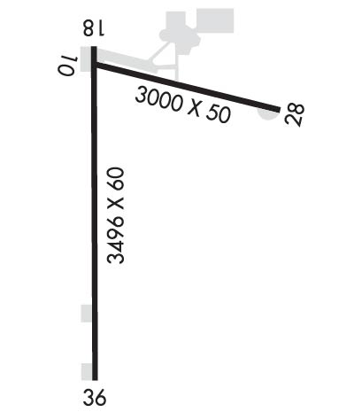
| Lat: N 3424.7 Long: W 09127.9 Elev: 210 Var: -02 Longest Runway: 3494 | ||
| Clr Del: 119.85 CTAF: 123.0 | ||
| ||||||||||||||||||||||||||||||||||||||||||||
| ||||||||||||||||||||||||||||||||||||||||||||
| Rwy | Rwy | |||||||
| 3000x50 | 3000' | 3000x50 | 3000' | |||||
| 3494x60 | 3456' | 3494x60 | 3494' | |||||
| Runway ID | Single Wheel | Double Wheel | Double Tandem Wheel | Dual Double Wheel |
| 10/28 | 4,000 | N/A | N/A | N/A |
| 18/36 | 4,000 | N/A | N/A | N/A |
| These numbers are Advisory and are not limits. The Airport Manager should have more accurate Weight Limits | ||||
 Airport Diagram might not be current. | |
| Facility Name: | ALMYRA MUNI |
| City Name: | ALMYRA |
| County: | ARKANSAS |
| State abbrev: | AR |
| State Name: | ARKANSAS |
| Ownership: | PUBLICLY OWNED |
| Use: | OPEN TO THE PUBLIC |
| Owner's Name: | CITY OF ALMYRA |
| Address: | P O BOX 213 |
| ALMYRA, AR 72003 | |
| Owner's Phone: | 870-673-1591 |
| Manager's Name: | MARK HARTZ |
| Address: | 275 ALMYRA AIRPORT ROAD |
| ALMYRA, AR 72003 | |
| Phone: | (870) 830-1231 |
| FAA Region: | SOUTHWEST |
| FAA Field Office: | AOK |
| Date | Sunrise | Sunset |
|---|---|---|
| 04/25/24 Thursday | 6:22 | 19:46 |
| 04/26/24 Friday | 6:21 | 19:47 |
| 04/27/24 Saturday | 6:19 | 19:48 |
| 04/28/24 Sunday | 6:18 | 19:49 |
| 04/29/24 Monday | 6:17 | 19:49 |
| 04/30/24 Tuesday | 6:16 | 19:50 |
| 05/01/24 Wednesday | 6:15 | 19:51 |
| 05/02/24 Thursday | 6:14 | 19:52 |
| 05/03/24 Friday | 6:13 | 19:53 |
| 05/04/24 Saturday | 6:12 | 19:53 |
| 05/05/24 Sunday | 6:11 | 19:54 |
| 05/06/24 Monday | 6:10 | 19:55 |
| 05/07/24 Tuesday | 6:09 | 19:56 |
| 05/08/24 Wednesday | 6:09 | 19:56 |
| Airport Attendance Schedule | MON-FRI 0800-1700 |
| Airport Status | OPERATIONAL (This Status can change at any time - please check NOTAMS) |
| Airport Lighting Schedule | ACTVT MIRL RY 18/36, PAPI RYS 18 & 36 - CTAF. |
| Airport Storage Available | Tie Downs |
| Extra Services Available | Crop Dusting |
| Wind Indicator | YES - (lighted) |
| Control Tower | NO |
| CTAF Frequency | 123.000 |
| Unicom Frequency | 123.000 |
| Rotating Beacon Color | WG |
| Segmented Circle | YES |
| Landing Fee | NO |
| Airport Inspected | STATE - performed by STATE AERONAUTICAL PERSONNEL |
| Inspection Date | 01/04/2023 |
| Type of Fuel Available | Grade 100LL; -10100 LL SELF SERVE AVBL WITH CREDIT CARD. FOR SVC AFT HRS CALL 870-830-1231. |
| Airframe Repair Service | MINOR |
| Power Plant Repair Service | MINOR |
| Latitude | N3424.7 |
| Longitude | W09127.9 (ESTIMATED) |
| Arpt Elevation | 210ft (SURVEYED) |
| Magnetic Variation | 02E |
| 3 miles W | of ALMYRA |
| Traffic Pattern Altitude | |
| Sectional Chart | MEMPHIS |
| Operations (Reported) | Yearly | Avg. Daily |
|---|---|---|
| General Aviation Transient | 4000 | 11 |
| General Aviation Local | 50000 | 137 |
| Air Taxi | 0 | 0 |
| Commerical | 0 | 0 |
| Commuter | 0 | 0 |
| Military | 100 | 0 |
| Aircraft based on Field | |
|---|---|
| General Aviation Singles | 11 |
| General Aviation Multi | 0 |
| Jet Aircraft | 0 |
| General Aviation Helicopters | 0 |
| Military Aircraft | 0 |
| Gliders | 0 |
| Ultralights | 0 |
| FSS on field | NO |
| FSS tie-in | JONESBORO |
| FSS Phone | 1-800-WX-BRIEF |
| Who issues Notams | JBR |
| Notam D service at airport | YES |
| ARTCC Name | MEMPHIS |
| Airport Certification | |
| Aircraft Rescue & Firefighting Index | None |
| Airport of Entry | No |
| Custom Landing Rights | No |
| Joint Civil/Military | No |
| Military Landing rights | YES |
| NATIONAL PLAN OF INTEGRATED AIRPORT SYSTEMS (NPIAS) |
| SURPLUS PROPERTY AGREEMENT UNDER REGULATION 16-WAA |
| ASSURANCES PURSUANT TO TITLE VI, CIVIL RIGHTS ACT OF 1964 |
| GRANT AGREEMENT HAS EXPIRED; HOWEVER, AGREEMENT REMAINS IN EFFECT FOR THIS FACILITY AS LONG AS IT IS PUBLIC USE. |
| MIGRATORY BIRDS ON & INVOF AIRPORT NOV-FEB |
| NUMEROUS AGRICULTURAL ACFT OPNS |
| FOR CD WHEN UNA VIA FREQ CTC LITTLE ROCK APCH 501-379-2908 OR LITTLE ROCK ATCT 501-379-2911 |
Airport Communications & Frequencies:
| ||||||||||||||||
| Runway: 10 | Runway: 28 | ||
| Mag heading: | 104° | Mag heading: | 284° |
| Rwy Slope: | -.16% Down | Rwy Slope: | .16% Up |
| Approach: | Approach: | ||
| Pattern: | Left Traffic | Pattern: | Left Traffic |
| Markings: | BASIC | Markings: | BASIC |
| Marking Condition: | FAIR | Marking Condition: | FAIR |
| Arresting Dev: | Arresting Dev: | ||
| Lat & Long: | N3424.9 W09128.1 | Lat. & Long.: | N3424.8 W09127.5 |
| Elev: | 208.9 ft. MSL | Elev: | 204.1 ft. MSL |
| TCH: | TCH: | ||
| Visual Glide Path: | Visual Glide Path: | ||
| Displaced Threshold: | No | Displaced Threshold: | No |
| Touchdown Zone: | YES | Touchdown Zone: | YES |
| Touchdown Elev.: | 210.2 feet | Touchdown Elev.: | 210.2 feet |
| Visual Glide Slope: | Visual Glide Slope: | ||
| RVR Equipment: | RVR Equipment: | ||
| RVV Equipment: | NO | RVV Equipment: | NO |
| Approach Lights: | Approach Lights: | ||
| REIL: | NO | REIL: | NO |
| Centerline Lights: | NO | Centerline Lights: | NO |
| Touchdown lights: | NO | Touchdown lights: | NO |
| Runway Category: | Runway with a Visual Approach | Runway Category: | Runway with a Visual Approach |
| Declared Distances: | Declared Distances: | ||
| Obstructions: | Obstructions: | TREES | |
| Marked: | Marked: | NOT Marked/Lighted | |
| Clearance slope: | Clearance slope: | 17:1 | |
| Obstruction height: | Obstruction height: | 20 feet AGL | |
| Dist. from runway: | Dist. from runway: | 540 feet | |
| Centerline offset: | Centerline offset: | 115 feet right of centerline | |
| Comments: | 10 FT GRVL ROAD 0 FT FM THLD. | Comments: |
| Runway: 18 | Runway: 36 | ||
| Mag heading: | 179° | Mag heading: | 359° |
| Rwy Slope: | -.16% Down | Rwy Slope: | .16% Up |
| Approach: | Approach: | ||
| Pattern: | Left Traffic | Pattern: | Left Traffic |
| Markings: | BASIC | Markings: | NONPRECISION INSTRUMENT |
| Marking Condition: | POOR; RWY 18 MARKINGS FADED | Marking Condition: | FAIR |
| Arresting Dev: | Arresting Dev: | ||
| Lat & Long: | N3424.9 W09128.0 | Lat. & Long.: | N3424.4 W09128.1 |
| Elev: | 208.8 ft. MSL | Elev: | 203.1 ft. MSL |
| TCH: | 39 ft. AGL | TCH: | 37 ft. AGL |
| Visual Glide Path: | 3.00 degrees | Visual Glide Path: | 3.00 degrees |
| Displaced Threshold: | 38 feet | Displaced Threshold: | No |
| Touchdown Zone: | YES | Touchdown Zone: | YES |
| Touchdown Elev.: | 209.3 feet | Touchdown Elev.: | 208.9 feet |
| Visual Glide Slope: | 2-Light PAPI on RIGHT side of Runway | Visual Glide Slope: | 2-Light PAPI on LEFT side of Runway |
| RVR Equipment: | RVR Equipment: | ||
| RVV Equipment: | NO | RVV Equipment: | NO |
| Approach Lights: | Approach Lights: | ||
| REIL: | NO | REIL: | NO |
| Centerline Lights: | NO | Centerline Lights: | NO |
| Touchdown lights: | NO | Touchdown lights: | NO |
| Runway Category: | Runway with a Visual Approach | Runway Category: | Runway with a Non-precision Approach |
| Declared Distances: | Declared Distances: | ||
| Obstructions: | ROAD | Obstructions: | |
| Marked: | NOT Marked/Lighted | Marked: | |
| Clearance slope: | 16:1; RWY 18 APCH RATIO FROM DSPLCD THLD 32:1 | Clearance slope: | 50:1 |
| Obstruction height: | 15 feet AGL | Obstruction height: | |
| Dist. from runway: | 450 feet | Dist. from runway: | |
| Centerline offset: | Centerline offset: | ||
| Comments: | Comments: |
Thanks for using FltPlan.com
all rights reserved © 1999-2024 by Flight Plan LLC
