
| ANGELINA COUNTY LUFKIN TX |
| |
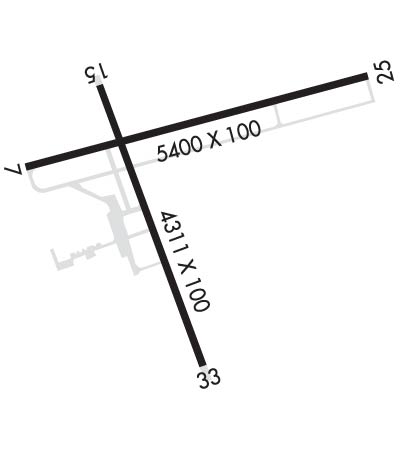
| Lat: N 3114.0 Long: W 09445.0 Elev: 296 Var: -02 Longest Runway: 5400 | ||
| AWOS: 120.62 CTAF: 123.0 | ||
| ||||||||||||||||||||||||||||||||||||||||||||
| ||||||||||||||||||||||||||||||||||||||||||||
| ||||||||||||||||||||||||||||||||||||||||||||
| Rwy | Rwy | |||||||
| 5400x100 | 5400' | 111.30 - 073° | 5400x100 | 5400' | ||||
| 4311x100 | 4311' | 4311x100 | 4204' | |||||
| Runway ID | Single Wheel | Double Wheel | Double Tandem Wheel | Dual Double Wheel |
| 07/25 | 60,000 | 90,000 | N/A | N/A |
| 16/34 | 30,000 | N/A | N/A | N/A |
| These numbers are Advisory and are not limits. The Airport Manager should have more accurate Weight Limits | ||||
 Airport Diagram might not be current. | |
| Facility Name: | ANGELINA COUNTY |
| City Name: | LUFKIN |
| County: | ANGELINA |
| State abbrev: | TX |
| State Name: | TEXAS |
| Ownership: | PUBLICLY OWNED |
| Use: | OPEN TO THE PUBLIC |
| Owner's Name: | ANGELINA COUNTY |
| Address: | COUNTY COURTHOUSE |
| LUFKIN, TX 75901 | |
| Owner's Phone: | 936-634-5413 |
| Manager's Name: | GARY LETNEY |
| Address: | 800 AIRPORT BLVD. |
| DIBOLL, TX 75941 | |
| Phone: | 936-634-7511 |
| FAA Region: | SOUTHWEST |
| FAA Field Office: | TEX |
| Date | Sunrise | Sunset |
|---|---|---|
| 04/25/24 Thursday | 6:39 | 19:55 |
| 04/26/24 Friday | 6:38 | 19:55 |
| 04/27/24 Saturday | 6:37 | 19:56 |
| 04/28/24 Sunday | 6:36 | 19:57 |
| 04/29/24 Monday | 6:35 | 19:58 |
| 04/30/24 Tuesday | 6:34 | 19:58 |
| 05/01/24 Wednesday | 6:34 | 19:59 |
| 05/02/24 Thursday | 6:33 | 20:00 |
| 05/03/24 Friday | 6:32 | 20:00 |
| 05/04/24 Saturday | 6:31 | 20:01 |
| 05/05/24 Sunday | 6:30 | 20:02 |
| 05/06/24 Monday | 6:29 | 20:02 |
| 05/07/24 Tuesday | 6:28 | 20:03 |
| 05/08/24 Wednesday | 6:28 | 20:04 |
| Airport Attendance Schedule | MON-FRI 0700-1900, SAT-SUN 0900-1900 |
| Airport Status | OPERATIONAL (This Status can change at any time - please check NOTAMS) |
| Airport Lighting Schedule | DUSK-DAWN. MIRL RWYS 07/25 & 16/34 PRESET MED INTST; TO INCR INTST AND ACTVT MALSR RWY 07 - CTAF. PAPI RWY 25; VASI RWY 16 & 34 OPR CONSLY. |
| Airport Storage Available | Tie Downs, Hanger |
| Extra Services Available | NONE |
| Wind Indicator | YES - (lighted) |
| Control Tower | NO |
| CTAF Frequency | 123.000 |
| Unicom Frequency | 123.000; UNICOM MNT FM 0600-1900. |
| Rotating Beacon Color | WG |
| Segmented Circle | YES |
| Landing Fee | NO |
| Airport Inspected | STATE - performed by STATE AERONAUTICAL PERSONNEL |
| Inspection Date | 04/03/2023 |
| Type of Fuel Available | Grade 100LL, JET A; -10SVC FEE CHRGD FOR FUEL AFT 1900; CALL 936-635-1542. |
| Airframe Repair Service | MINOR |
| Power Plant Repair Service | MINOR |
| Latitude | N3114.0 |
| Longitude | W09445.0 (ESTIMATED) |
| Arpt Elevation | 295ft (SURVEYED) |
| Magnetic Variation | 02E |
| 7 miles SW | of LUFKIN |
| Traffic Pattern Altitude | |
| Sectional Chart | HOUSTON |
| Operations (Reported) | Yearly | Avg. Daily |
|---|---|---|
| General Aviation Transient | 12000 | 33 |
| General Aviation Local | 7300 | 20 |
| Air Taxi | 2200 | 6 |
| Commerical | 0 | 0 |
| Commuter | 0 | 0 |
| Military | 1500 | 4 |
| Aircraft based on Field | |
|---|---|
| General Aviation Singles | 48 |
| General Aviation Multi | 9 |
| Jet Aircraft | 2 |
| General Aviation Helicopters | 3 |
| Military Aircraft | 0 |
| Gliders | 1 |
| Ultralights | 0 |
| FSS on field | NO |
| FSS tie-in | MONTGOMERY COUNTY |
| FSS Phone | 1-800-WX-BRIEF |
| Who issues Notams | LFK |
| Notam D service at airport | YES |
| ARTCC Name | HOUSTON |
| Airport Certification | |
| Aircraft Rescue & Firefighting Index | None |
| Airport of Entry | No |
| Custom Landing Rights | No |
| Joint Civil/Military | No |
| Military Landing rights | YES |
| NATIONAL PLAN OF INTEGRATED AIRPORT SYSTEMS (NPIAS) |
| GRANT AGREEMENTS UNDER FAAP/ADAP/AIP |
| ASSURANCES PURSUANT TO TITLE VI, CIVIL RIGHTS ACT OF 1964 |
| RWY 34 100 FT X 199 FT PAVED SAFETY AREA. |
| FOR CD IF UNA TO CTC ON FSS FREQ, CTC HOUSTON ARTCC AT 281-230-5622. |
| RWY 16/3 4 296 FT PAVED SWY NW END. |
Airport Communications & Frequencies:
| |||||||||
| Runway: 07 | Runway: 25 | ||
| Mag heading: | 73° | Mag heading: | 253° |
| Rwy Slope: | .21% Up | Rwy Slope: | -.21% Down |
| Approach: | ILS | Approach: | |
| Pattern: | Left Traffic | Pattern: | Left Traffic |
| Markings: | PRECISION INSTRUMENT | Markings: | NONPRECISION INSTRUMENT |
| Marking Condition: | GOOD | Marking Condition: | GOOD |
| Arresting Dev: | Arresting Dev: | ||
| Lat & Long: | N3114.1 W09445.4 | Lat. & Long.: | N3114.3 W09444.4 |
| Elev: | 284.1 ft. MSL | Elev: | 295.6 ft. MSL |
| TCH: | TCH: | 45 ft. AGL | |
| Visual Glide Path: | Visual Glide Path: | 3.00 degrees | |
| Displaced Threshold: | No | Displaced Threshold: | No |
| Touchdown Zone: | YES | Touchdown Zone: | YES |
| Touchdown Elev.: | 286.6 feet | Touchdown Elev.: | 295.6 feet |
| Visual Glide Slope: | Visual Glide Slope: | 4-Light PAPI on LEFT side of Runway | |
| RVR Equipment: | RVR Equipment: | ||
| RVV Equipment: | NO | RVV Equipment: | NO |
| Approach Lights: | MALSR - 1,400 foot medium intensity approach lighting system with runway alignment indicator lights | Approach Lights: | |
| REIL: | NO | REIL: | NO |
| Centerline Lights: | NO | Centerline Lights: | NO |
| Touchdown lights: | NO | Touchdown lights: | NO |
| Runway Category: | Precision Instrument Runway | Runway Category: | Runway with a Non-precision Approach having visibility minimums greater than 3/4 mile |
| Declared Distances: | Declared Distances: | ||
| Obstructions: | TREE | Obstructions: | TREES |
| Marked: | NOT Marked/Lighted | Marked: | NOT Marked/Lighted |
| Clearance slope: | 37:1 | Clearance slope: | 21:1 |
| Obstruction height: | 84 feet AGL | Obstruction height: | 67 feet AGL |
| Dist. from runway: | 3315 feet | Dist. from runway: | 1660 feet |
| Centerline offset: | 230 left of centerline | Centerline offset: | 505B |
| Comments: | Comments: |
| Runway: 16 | Runway: 34 | ||
| Mag heading: | 158° | Mag heading: | 338° |
| Rwy Slope: | -.36% Down | Rwy Slope: | .36% Up |
| Approach: | Approach: | ||
| Pattern: | Left Traffic | Pattern: | Left Traffic |
| Markings: | NONPRECISION INSTRUMENT | Markings: | NONPRECISION INSTRUMENT |
| Marking Condition: | GOOD | Marking Condition: | GOOD |
| Arresting Dev: | Arresting Dev: | ||
| Lat & Long: | N3114.2 W09445.2 | Lat. & Long.: | N3113.5 W09444.9 |
| Elev: | 289.2 ft. MSL | Elev: | 273.6 ft. MSL |
| TCH: | 48 ft. AGL | TCH: | 55 ft. AGL |
| Visual Glide Path: | 3.00 degrees | Visual Glide Path: | 3.00 degrees |
| Displaced Threshold: | No | Displaced Threshold: | 107 feet |
| Touchdown Zone: | YES | Touchdown Zone: | YES |
| Touchdown Elev.: | 289.3 feet | Touchdown Elev.: | 286.4 feet |
| Visual Glide Slope: | 4-BOX VASI ON LEFT SIDE OF RUNWAY | Visual Glide Slope: | 4-BOX VASI ON LEFT SIDE OF RUNWAY |
| RVR Equipment: | RVR Equipment: | ||
| RVV Equipment: | NO | RVV Equipment: | NO |
| Approach Lights: | Approach Lights: | ||
| REIL: | NO | REIL: | NO |
| Centerline Lights: | NO | Centerline Lights: | NO |
| Touchdown lights: | NO | Touchdown lights: | NO |
| Runway Category: | Runway with a Non-precision Approach having visibility minimums greater than 3/4 mile | Runway Category: | Runway with a Non-precision Approach having visibility minimums greater than 3/4 mile |
| Declared Distances: | Declared Distances: | ||
| Obstructions: | TREE | Obstructions: | TREES |
| Marked: | NOT Marked/Lighted | Marked: | NOT Marked/Lighted |
| Clearance slope: | 7:1 | Clearance slope: | 19:1; APCH SLOPE 24;1 TO DSPLCD THR. |
| Obstruction height: | 58 feet AGL | Obstruction height: | 38 feet AGL |
| Dist. from runway: | 640 feet | Dist. from runway: | 930 feet |
| Centerline offset: | 203 right of centerline | Centerline offset: | 200 feet right of centerline |
| Comments: | Comments: |
Thanks for using FltPlan.com
all rights reserved © 1999-2024 by Flight Plan LLC