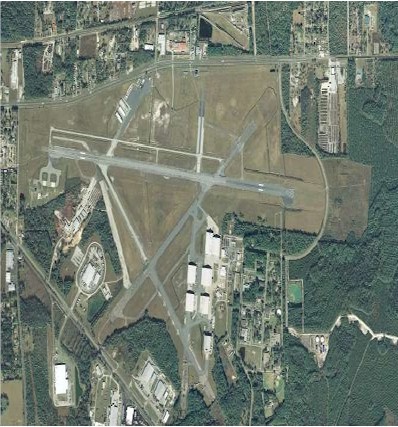
| LAKE CITY GATEWAY LAKE CITY FL |
| |
| Lat: N 3010.9 Long: W 08234.6 Elev: 201 Var: +03 Longest Runway: 8003 | ||
| AWOS: 120.67 Ground: 121.9 Tower: 119.2 | ||
| ||||||||||||||||||||||||||||||||||||||||||||
| ||||||||||||||||||||||||||||||||||||||||||||
| ||||||||||||||||||||||||||||||||||||||||||||
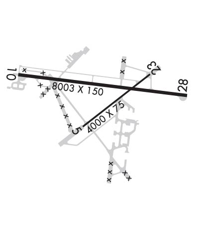
| Rwy | Rwy | |||||||
| 4000x75 | 4000' | 4000x75 | 4000' | |||||
| 8003x150 | 8003' | 8003x150 | 8003' | |||||
| Runway ID | Single Wheel | Double Wheel | Double Tandem Wheel | Dual Double Wheel |
| 05/23 | N/A | N/A | N/A | N/A |
| 10/28 | 75,000 | 105,000 | 250,000 | N/A |
| These numbers are Advisory and are not limits. The Airport Manager should have more accurate Weight Limits | ||||
 Airport Diagram might not be current. | |
| Facility Name: | LAKE CITY GATEWAY |
| City Name: | LAKE CITY |
| County: | COLUMBIA |
| State abbrev: | FL |
| State Name: | FLORIDA |
| Ownership: | PUBLICLY OWNED |
| Use: | OPEN TO THE PUBLIC |
| Owner's Name: | CITY OF LAKE CITY; CTC PERSON: DEMETRIUS JOHNSON |
| Address: | 205 NORTH MARION AVE |
| LAKE CITY, FL 32055 | |
| Owner's Phone: | 386-719-5785 |
| Manager's Name: | ED BUNNELL |
| Address: | 3524 E US HWY 90 |
| LAKE CITY, FL 32055 | |
| Phone: | 386-752-1066 |
| FAA Region: | SOUTHERN |
| FAA Field Office: | ORL |
| Date | Sunrise | Sunset |
|---|---|---|
| 04/25/24 Thursday | 6:52 | 20:05 |
| 04/26/24 Friday | 6:51 | 20:05 |
| 04/27/24 Saturday | 6:50 | 20:06 |
| 04/28/24 Sunday | 6:49 | 20:07 |
| 04/29/24 Monday | 6:48 | 20:07 |
| 04/30/24 Tuesday | 6:47 | 20:08 |
| 05/01/24 Wednesday | 6:47 | 20:09 |
| 05/02/24 Thursday | 6:46 | 20:09 |
| 05/03/24 Friday | 6:45 | 20:10 |
| 05/04/24 Saturday | 6:44 | 20:10 |
| 05/05/24 Sunday | 6:43 | 20:11 |
| 05/06/24 Monday | 6:42 | 20:12 |
| 05/07/24 Tuesday | 6:42 | 20:12 |
| 05/08/24 Wednesday | 6:41 | 20:13 |
| Airport Attendance Schedule | 7 Days A Week 0800-1800; TWR ATNDD OTR TIMES BY NOTAM. |
| Airport Status | OPERATIONAL (This Status can change at any time - please check NOTAMS) |
| Airport Lighting Schedule | ACTVT REIL RWY 10 & 28; MIRL RWY 5/23 & 10/28 - CTAF. |
| Airport Storage Available | Tie Downs, Hanger |
| Extra Services Available | Air Ambulance, Flight Instruction |
| Wind Indicator | YES - (lighted) |
| Control Tower | YES |
| CTAF Frequency | 119.200 |
| Unicom Frequency | 122.950 |
| Rotating Beacon Color | WG |
| Segmented Circle | YES |
| Landing Fee | NO |
| Airport Inspected | STATE - performed by STATE AERONAUTICAL PERSONNEL |
| Inspection Date | 04/04/2018 |
| Type of Fuel Available | Grade 100LL, JET A (freeze point -40C) |
| Airframe Repair Service | MINOR |
| Power Plant Repair Service | MINOR |
| Latitude | N3010.9 |
| Longitude | W08234.6 (ESTIMATED) |
| Arpt Elevation | 200ft (SURVEYED) |
| Magnetic Variation | 03W |
| 3 miles E | of LAKE CITY |
| Traffic Pattern Altitude | |
| Sectional Chart | JACKSONVILLE |
| Operations (Reported) | Yearly | Avg. Daily |
|---|---|---|
| General Aviation Transient | 13700 | 38 |
| General Aviation Local | 11114 | 30 |
| Air Taxi | 1300 | 4 |
| Commerical | 0 | 0 |
| Commuter | 0 | 0 |
| Military | 2600 | 7 |
| Aircraft based on Field | |
|---|---|
| General Aviation Singles | 22 |
| General Aviation Multi | 2 |
| Jet Aircraft | 2 |
| General Aviation Helicopters | 3 |
| Military Aircraft | 0 |
| Gliders | 0 |
| Ultralights | 0 |
| FSS on field | NO |
| FSS tie-in | GAINESVILLE |
| FSS Phone | 1-800-WX-BRIEF |
| Who issues Notams | GNV |
| Notam D service at airport | YES |
| ARTCC Name | JACKSONVILLE |
| Airport Certification | |
| Aircraft Rescue & Firefighting Index | None |
| Airport of Entry | No |
| Custom Landing Rights | No |
| Joint Civil/Military | No |
| Military Landing rights | YES |
| NATIONAL PLAN OF INTEGRATED AIRPORT SYSTEMS (NPIAS) |
| GRANT AGREEMENTS UNDER FAAP/ADAP/AIP |
| SURPLUS PROPERTY AGREEMENT UNDER PUBLIC LAW 289 |
| SURPLUS PROPERTY AGREEMENT UNDER REGULATION 16-WAA |
| ASSURANCES PURSUANT TO TITLE VI, CIVIL RIGHTS ACT OF 1964 |
| AGREEMENT UNDER DLAND OR DCLA HAS EXPIRED. |
| UNLIT 60 FT POLES ON MOVEMENT AREA. HELICOPTERS ADVISED TO TAXI ON PAVED AREAS ONLY. |
| WHEN ATCT CLSD, FOR CD CTC JACKSONVILLE ARTCC AT 904-845-1592. |
| RWY 05/2 3 PCR VALUE: 11/F/A/Y/T |
Airport Communications & Frequencies:
| |||||||||||||||||
| Runway: 05 | Runway: 23 | ||
| Mag heading: | 55° | Mag heading: | 235° |
| Rwy Slope: | .23% Up | Rwy Slope: | -.23% Down |
| Approach: | Approach: | ||
| Pattern: | Left Traffic | Pattern: | Left Traffic |
| Markings: | NONPRECISION INSTRUMENT | Markings: | NONPRECISION INSTRUMENT |
| Marking Condition: | GOOD | Marking Condition: | GOOD |
| Arresting Dev: | Arresting Dev: | ||
| Lat & Long: | N3010.6 W08234.8 | Lat. & Long.: | N3011.0 W08234.2 |
| Elev: | 185.5 ft. MSL | Elev: | 194.8 ft. MSL |
| TCH: | TCH: | ||
| Visual Glide Path: | Visual Glide Path: | ||
| Displaced Threshold: | No | Displaced Threshold: | No |
| Touchdown Zone: | YES | Touchdown Zone: | YES |
| Touchdown Elev.: | 195.8 feet | Touchdown Elev.: | 195.8 feet |
| Visual Glide Slope: | Visual Glide Slope: | ||
| RVR Equipment: | RVR Equipment: | ||
| RVV Equipment: | NO | RVV Equipment: | NO |
| Approach Lights: | Approach Lights: | ||
| REIL: | NO | REIL: | NO |
| Centerline Lights: | NO | Centerline Lights: | NO |
| Touchdown lights: | NO | Touchdown lights: | NO |
| Runway Category: | Runway with a Visual Approach | Runway Category: | Runway with a Visual Approach |
| Declared Distances: | Declared Distances: | ||
| Obstructions: | TREES | Obstructions: | TREES |
| Marked: | NOT Marked/Lighted | Marked: | NOT Marked/Lighted |
| Clearance slope: | 23:1 | Clearance slope: | 28:1 |
| Obstruction height: | 64 feet AGL | Obstruction height: | 50 feet AGL |
| Dist. from runway: | 1690 feet | Dist. from runway: | 1625 feet |
| Centerline offset: | 250 right of centerline | Centerline offset: | 265 feet left of centerline |
| Comments: | Comments: |
| Runway: 10 | Runway: 28 | ||
| Mag heading: | 100° | Mag heading: | 280° |
| Rwy Slope: | -.02% Down | Rwy Slope: | .02% Up |
| Approach: | Approach: | ||
| Pattern: | Left Traffic | Pattern: | Right Traffic |
| Markings: | NONPRECISION INSTRUMENT | Markings: | NONPRECISION INSTRUMENT |
| Marking Condition: | FAIR | Marking Condition: | FAIR |
| Arresting Dev: | Arresting Dev: | ||
| Lat & Long: | N3011.0 W08235.4 | Lat. & Long.: | N3010.9 W08233.9 |
| Elev: | 198.1 ft. MSL | Elev: | 196.3 ft. MSL |
| TCH: | 53 ft. AGL | TCH: | 51 ft. AGL |
| Visual Glide Path: | 3.00 degrees | Visual Glide Path: | 3.00 degrees |
| Displaced Threshold: | No | Displaced Threshold: | No |
| Touchdown Zone: | YES | Touchdown Zone: | YES |
| Touchdown Elev.: | 200.7 feet | Touchdown Elev.: | 196.4 feet |
| Visual Glide Slope: | 2-Light PAPI on LEFT side of Runway | Visual Glide Slope: | 2-Light PAPI on LEFT side of Runway |
| RVR Equipment: | RVR Equipment: | ||
| RVV Equipment: | NO | RVV Equipment: | NO |
| Approach Lights: | Approach Lights: | ||
| REIL: | YES | REIL: | YES |
| Centerline Lights: | NO | Centerline Lights: | NO |
| Touchdown lights: | NO | Touchdown lights: | NO |
| Runway Category: | Runway with a Non-precision Approach having visibility minimums greater than 3/4 mile | Runway Category: | Runway with a Non-precision Approach having visibility minimums greater than 3/4 mile |
| Declared Distances: | Declared Distances: | ||
| Obstructions: | TREES | Obstructions: | TREES |
| Marked: | NOT Marked/Lighted | Marked: | NOT Marked/Lighted |
| Clearance slope: | 21:1 | Clearance slope: | 35:1 |
| Obstruction height: | 57 feet AGL | Obstruction height: | 48 feet AGL |
| Dist. from runway: | 1425 feet | Dist. from runway: | 1885 feet |
| Centerline offset: | 170 left of centerline | Centerline offset: | 250 feet right of centerline |
| Comments: | Comments: |
Thanks for using FltPlan.com
all rights reserved © 1999-2024 by Flight Plan LLC