
| CALIFORNIA CITY MUNI CALIFORNIA CITY CA |
| |
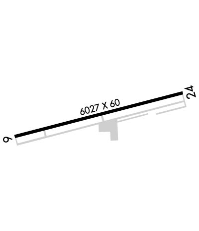
| Lat: N 3509.1 Long: W 11801.0 Elev: 2454 Var: -14 Longest Runway: 6027 | ||
| AWOS: 120.87 CTAF: 122.7 | ||
| ||||||||||||||||||||||||||||||||||||||||||||
| ||||||||||||||||||||||||||||||||||||||||||||
| ||||||||||||||||||||||||||||||||||||||||||||
| Rwy | Rwy | |||||||
| 6027x60 | 6027' | 6027x60 | 6027' | |||||
| Runway ID | Single Wheel | Double Wheel | Double Tandem Wheel | Dual Double Wheel |
| 06/24 | 26,000 | N/A | N/A | N/A |
| These numbers are Advisory and are not limits. The Airport Manager should have more accurate Weight Limits | ||||
 Airport Diagram might not be current. | |
| Facility Name: | CALIFORNIA CITY MUNI |
| City Name: | CALIFORNIA CITY |
| County: | KERN |
| State abbrev: | CA |
| State Name: | CALIFORNIA |
| Ownership: | PUBLICLY OWNED |
| Use: | OPEN TO THE PUBLIC |
| Owner's Name: | CITY OF CALIFORNIA CITY |
| Address: | 21000 HACIENDA BLVD |
| CALIFORNIA CITY, CA 93505 | |
| Owner's Phone: | (760) 559-3628 |
| Manager's Name: | ROBERT KING |
| Address: | 21000 HACIENDA BOULEVARD |
| CALIFORNIA CITY, CA 93505 | |
| Phone: | (760) 559-3628 |
| FAA Region: | WESTERN-PACIFIC |
| FAA Field Office: | LAX |
| Date | Sunrise | Sunset |
|---|---|---|
| 04/26/24 Friday | 6:06 | 19:34 |
| 04/27/24 Saturday | 6:04 | 19:35 |
| 04/28/24 Sunday | 6:03 | 19:36 |
| 04/29/24 Monday | 6:02 | 19:37 |
| 04/30/24 Tuesday | 6:01 | 19:38 |
| 05/01/24 Wednesday | 6:00 | 19:39 |
| 05/02/24 Thursday | 5:59 | 19:39 |
| 05/03/24 Friday | 5:58 | 19:40 |
| 05/04/24 Saturday | 5:57 | 19:41 |
| 05/05/24 Sunday | 5:56 | 19:42 |
| 05/06/24 Monday | 5:55 | 19:43 |
| 05/07/24 Tuesday | 5:54 | 19:43 |
| 05/08/24 Wednesday | 5:53 | 19:44 |
| 05/09/24 Thursday | 5:52 | 19:45 |
| Airport Attendance Schedule | 7 Days A Week 0800-1700 |
| Airport Status | OPERATIONAL (This Status can change at any time - please check NOTAMS) |
| Airport Lighting Schedule | ACTVT REIL RWY 24, MIRL RWY 06/24 - CTAF. PAPI RWY 24 OPER CONT. |
| Airport Storage Available | Tie Downs |
| Extra Services Available | Glider, Flight Instruction, Parachute Jumping, Aircraft Rental, Glider Towing |
| Wind Indicator | YES - (lighted) |
| Control Tower | NO |
| CTAF Frequency | 122.700 |
| Unicom Frequency | 122.700 |
| Rotating Beacon Color | WG |
| Segmented Circle | YES |
| Landing Fee | NO |
| Airport Inspected | STATE - performed by STATE AERONAUTICAL PERSONNEL |
| Inspection Date | 05/25/2023 |
| Type of Fuel Available | Grade 100LL, JET A (freeze point -40C) |
| Airframe Repair Service | MINOR |
| Power Plant Repair Service | MINOR |
| Latitude | N3509.1 |
| Longitude | W11801.0 (ESTIMATED) |
| Arpt Elevation | 2453ft (SURVEYED) |
| Magnetic Variation | 14E |
| 2 miles NW | of CALIFORNIA CITY |
| Traffic Pattern Altitude | |
| Sectional Chart | LOS ANGELES |
| Operations (Reported) | Yearly | Avg. Daily |
|---|---|---|
| General Aviation Transient | 1500 | 4 |
| General Aviation Local | 1850 | 5 |
| Air Taxi | 0 | 0 |
| Commerical | 0 | 0 |
| Commuter | 0 | 0 |
| Military | 200 | 1 |
| Aircraft based on Field | |
|---|---|
| General Aviation Singles | 3 |
| General Aviation Multi | 0 |
| Jet Aircraft | 2 |
| General Aviation Helicopters | 0 |
| Military Aircraft | 0 |
| Gliders | 3 |
| Ultralights | 0 |
| FSS on field | NO |
| FSS tie-in | RIVERSIDE |
| FSS Phone | 1-800-WX-BRIEF |
| Who issues Notams | RAL |
| Notam D service at airport | YES |
| ARTCC Name | LOS ANGELES |
| Airport Certification | |
| Aircraft Rescue & Firefighting Index | None |
| Airport of Entry | No |
| Custom Landing Rights | No |
| Joint Civil/Military | No |
| Military Landing rights | No |
| NATIONAL PLAN OF INTEGRATED AIRPORT SYSTEMS (NPIAS) |
| THIS AIRPORT HAS BEEN SURVEYED BY THE NATIONAL GEODETIC SURVEY. |
| RY 06/24 PAEW ADJ RY 0700-1500 DLY. |
| FOR CD CTC JOSHUA APCH AT 661-277-3843. |
Airport Communications & Frequencies:
| ||||||||||||||
| Runway: 06 | Runway: 24 | ||
| Mag heading: | 62° | Mag heading: | 242° |
| Rwy Slope: | -.86% Down | Rwy Slope: | .86% Up |
| Approach: | Approach: | ||
| Pattern: | Left Traffic | Pattern: | Right Traffic |
| Markings: | BASIC | Markings: | BASIC |
| Marking Condition: | POOR; NO RWY CTRLN. THLD & RWY NR BARELY VSB. | Marking Condition: | POOR; NO RWY CTRLN. THLD & RWY NR BARELY VSB. |
| Arresting Dev: | Arresting Dev: | ||
| Lat & Long: | N3509.0 W11801.6 | Lat. & Long.: | N3509.2 W11800.4 |
| Elev: | 2453.5 ft. MSL | Elev: | 2401.4 ft. MSL |
| TCH: | TCH: | 40 ft. AGL | |
| Visual Glide Path: | Visual Glide Path: | 3.00 degrees | |
| Displaced Threshold: | No | Displaced Threshold: | No |
| Touchdown Zone: | YES | Touchdown Zone: | YES |
| Touchdown Elev.: | 2453.5 feet | Touchdown Elev.: | 2428.8 feet |
| Visual Glide Slope: | Visual Glide Slope: | 2-Light PAPI on LEFT side of Runway | |
| RVR Equipment: | RVR Equipment: | ||
| RVV Equipment: | NO | RVV Equipment: | NO |
| Approach Lights: | Approach Lights: | ||
| REIL: | NO | REIL: | YES |
| Centerline Lights: | NO | Centerline Lights: | NO |
| Touchdown lights: | NO | Touchdown lights: | NO |
| Runway Category: | Runway with a Non-precision Approach | Runway Category: | Runway with a Non-precision Approach |
| Declared Distances: | Declared Distances: |
Thanks for using FltPlan.com
all rights reserved © 1999-2024 by Flight Plan LLC
