
| OCRACOKE ISLAND OCRACOKE NC |
| |
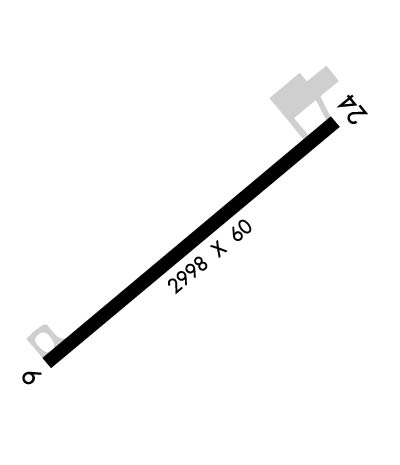
| Lat: N 3506.1 Long: W 07558.0 Elev: 4 Var: +09 Longest Runway: 2998 | ||
| AWOS: 404 CTAF: 122.9 | ||
| ||||||||||||||||||||||||||||||||
| ||||||||||||||||||||||||||||||||
| ||||||||||||||||||||||||||||||||
| Rwy | Rwy | |||||||
| 2998x60 | 2998' | 2998x60 | 2998' | |||||
| Runway ID | Single Wheel | Double Wheel | Double Tandem Wheel | Dual Double Wheel |
| 06/24 | 30,000 | N/A | N/A | N/A |
| H1 | N/A | N/A | N/A | N/A |
| These numbers are Advisory and are not limits. The Airport Manager should have more accurate Weight Limits | ||||
 Airport Diagram might not be current. | |
| Facility Name: | OCRACOKE ISLAND |
| City Name: | OCRACOKE |
| County: | HYDE |
| State abbrev: | NC |
| State Name: | NORTH CAROLINA |
| Ownership: | PUBLICLY OWNED |
| Use: | OPEN TO THE PUBLIC |
| Owner's Name: | NATIONAL PARK SERVICE; ARPT LEASED TO NC DOT UNDER SPECIAL-USE PERMIT; CTC NR 919-814-0550. |
| Address: | 1401 NATIONAL PARK DR. |
| MANTEO, NC 27954 | |
| Owner's Phone: | 252-475-9000 |
| Manager's Name: | MARK SEAMAN |
| Address: | 1401 NATIONAL PARK DRIVE |
| MANTEO, NC 27954 | |
| Phone: | 252-475-9000; NATL PARKS SVC NR ANSWERED 7 DAYS A WEEK BTWN 0800 TO 1700. |
| FAA Region: | SOUTHERN |
| FAA Field Office: | MEM |
| Date | Sunrise | Sunset |
|---|---|---|
| 04/24/24 Wednesday | 6:20 | 19:44 |
| 04/25/24 Thursday | 6:19 | 19:45 |
| 04/26/24 Friday | 6:18 | 19:46 |
| 04/27/24 Saturday | 6:16 | 19:47 |
| 04/28/24 Sunday | 6:15 | 19:48 |
| 04/29/24 Monday | 6:14 | 19:49 |
| 04/30/24 Tuesday | 6:13 | 19:49 |
| 05/01/24 Wednesday | 6:12 | 19:50 |
| 05/02/24 Thursday | 6:11 | 19:51 |
| 05/03/24 Friday | 6:10 | 19:52 |
| 05/04/24 Saturday | 6:09 | 19:53 |
| 05/05/24 Sunday | 6:08 | 19:53 |
| 05/06/24 Monday | 6:07 | 19:54 |
| 05/07/24 Tuesday | 6:06 | 19:55 |
| Airport Attendance Schedule | UNATTENDED |
| Airport Status | OPERATIONAL (This Status can change at any time - please check NOTAMS) |
| Airport Lighting Schedule | ACTVT HELI PERIMETER LTS ONLY - CTAF.; ACTVT HELI BEACON - CTAF. |
| Airport Storage Available | Tie Downs |
| Extra Services Available | NONE |
| Wind Indicator | YES - (unlit) |
| Control Tower | NO |
| CTAF Frequency | 122.900 |
| Unicom Frequency | |
| Rotating Beacon Color | WGY |
| Segmented Circle | NO |
| Landing Fee | NO |
| Airport Inspected | STATE - performed by STATE AERONAUTICAL PERSONNEL |
| Inspection Date | 09/02/2022 |
| Type of Fuel Available | None |
| Airframe Repair Service | NONE |
| Power Plant Repair Service | NONE |
| Latitude | N3506.1 |
| Longitude | W07558.0 (ESTIMATED) |
| Arpt Elevation | 4ft (SURVEYED) |
| Magnetic Variation | 09W |
| 1 miles E | of OCRACOKE |
| Traffic Pattern Altitude | |
| Sectional Chart | CHARLOTTE |
| Operations (Reported) | Yearly | Avg. Daily |
|---|---|---|
| General Aviation Transient | 3000 | 8 |
| General Aviation Local | 3000 | 8 |
| Air Taxi | 0 | 0 |
| Commerical | 0 | 0 |
| Commuter | 0 | 0 |
| Military | 100 | 0 |
| Aircraft based on Field | |
|---|---|
| General Aviation Singles | 0 |
| General Aviation Multi | 0 |
| Jet Aircraft | 0 |
| General Aviation Helicopters | 0 |
| Military Aircraft | 0 |
| Gliders | 0 |
| Ultralights | 0 |
| FSS on field | NO |
| FSS tie-in | RALEIGH |
| FSS Phone | 1-800-WX-BRIEF |
| Who issues Notams | RDU |
| Notam D service at airport | YES |
| ARTCC Name | WASHINGTON |
| Airport Certification | |
| Aircraft Rescue & Firefighting Index | None |
| Airport of Entry | No |
| Custom Landing Rights | No |
| Joint Civil/Military | No |
| Military Landing rights | No |
| NATIONAL PLAN OF INTEGRATED AIRPORT SYSTEMS (NPIAS) |
| ARPT CLSD 30 MIN AFTER SS TIL 30 MIN BEFORE SR. |
| FOR CD CTC WASHINGTON ARTCC AT 703-771-3587. |
| 30 FT PLINE ALONG NC HWY 12 N OF HELIPAD. |
| HIGH SPEED LOW LEVEL MIL OPS INVOF OF ARPT. |
| FLOCKS OF SEAGULLS ON AND NEAR RWY ARND STANDING WATER AFTER HVY RAINS. |
| RWY SAFETY AREA IS LOOSE SAND; NOT SUITABLE FOR ACFT. |
| RWY NOT LGTD - NIGHT OPS PROHIBITED. |
| ARPT IS WI CAPE HATTERAS NTL SEASHORE. MNTN 2000 FT VER & HORIZONTAL DIST FROM SEASHORE BEACHES. |
| RWY SUBJECT TO RESIDUAL FLOODING DURING AND AFTER HEAVY RAIN. |
| KEY CODE ACES TO PILOT LOUNGE. |
| HELIPAD FOR EMERG OPS ONLY. |
| RWY H1 BEST APCH FM NE OR SW. |
Airport Communications & Frequencies:
| ||||||||||||
| Runway: 06 | Runway: 24 | ||
| Mag heading: | 59° | Mag heading: | 239° |
| Rwy Slope: | .00% | Rwy Slope: | .00% |
| Approach: | Approach: | ||
| Pattern: | Left Traffic | Pattern: | Left Traffic |
| Markings: | NONPRECISION INSTRUMENT | Markings: | NONPRECISION INSTRUMENT |
| Marking Condition: | GOOD | Marking Condition: | GOOD |
| Arresting Dev: | Arresting Dev: | ||
| Lat & Long: | N3505.9 W07558.2 | Lat. & Long.: | N3506.2 W07557.7 |
| Elev: | 3.9 ft. MSL | Elev: | 3.9 ft. MSL |
| TCH: | TCH: | ||
| Visual Glide Path: | Visual Glide Path: | ||
| Displaced Threshold: | No | Displaced Threshold: | No |
| Touchdown Zone: | YES | Touchdown Zone: | YES |
| Touchdown Elev.: | 3.9 feet | Touchdown Elev.: | 3.9 feet |
| Visual Glide Slope: | Visual Glide Slope: | ||
| RVR Equipment: | RVR Equipment: | ||
| RVV Equipment: | NO | RVV Equipment: | NO |
| Approach Lights: | Approach Lights: | ||
| REIL: | NO | REIL: | NO |
| Centerline Lights: | NO | Centerline Lights: | NO |
| Touchdown lights: | NO | Touchdown lights: | NO |
| Runway Category: | Runway with a Non-precision Approach | Runway Category: | Runway with a Non-precision Approach |
| Declared Distances: | Declared Distances: | ||
| Obstructions: | BRUSH | Obstructions: | TREES |
| Marked: | NOT Marked/Lighted | Marked: | NOT Marked/Lighted |
| Clearance slope: | 1:1 | Clearance slope: | 10:1 |
| Obstruction height: | 11 feet AGL | Obstruction height: | 23 feet AGL |
| Dist. from runway: | 202 feet | Dist. from runway: | 438 feet |
| Centerline offset: | 135 left of centerline | Centerline offset: | 141 feet right of centerline |
| Comments: | 6 FT BRUSH 0-200 FT FM THR 83 FT R OF CNTRLN; 10 FT BUSHES 0-200 FT FM THR 157 FT L OF CNTRLN. | Comments: | 15 FT SCRUB TREES 151 FT FM THR 103 FT R OF CNTRLN; 14 FT SCRUB TREES 0-200 FT FM THR 60 FT L OF CNTRLN. |
Thanks for using FltPlan.com
all rights reserved © 1999-2024 by Flight Plan LLC
