
| GARNER FIELD UVALDE TX |
| |
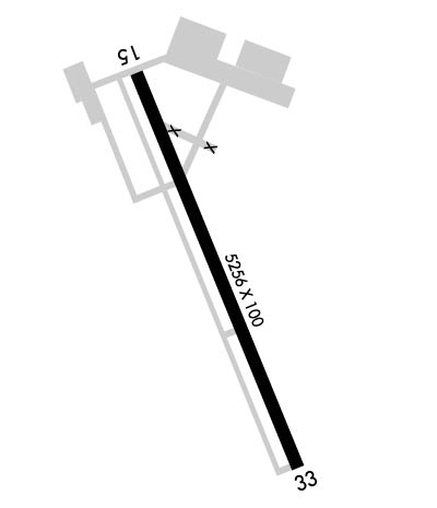
| Lat: N 2912.7 Long: W 09944.6 Elev: 942 Var: -07 Longest Runway: 5256 | ||
| AWOS: 124.17 CTAF: 122.8 | ||
| ||||||||||||||||||||||||||||||||||||||||||||
| ||||||||||||||||||||||||||||||||||||||||||||
| ||||||||||||||||||||||||||||||||||||||||||||
| Rwy | Rwy | |||||||
| 5256x100 | 5256' | 5256x100 | 5256' | |||||
| Runway ID | Single Wheel | Double Wheel | Double Tandem Wheel | Dual Double Wheel |
| 15/33 | 30,000 | 40,000 | 40,000 | N/A |
| These numbers are Advisory and are not limits. The Airport Manager should have more accurate Weight Limits | ||||
 Airport Diagram might not be current. | |
| Facility Name: | GARNER FLD |
| City Name: | UVALDE |
| County: | UVALDE |
| State abbrev: | TX |
| State Name: | TEXAS |
| Ownership: | PUBLICLY OWNED |
| Use: | OPEN TO THE PUBLIC |
| Owner's Name: | CITY OF UVALDE |
| Address: | PO BOX 799 |
| UVALDE, TX 78802 | |
| Owner's Phone: | 830-278-3315 |
| Manager's Name: | JOE A. CARDENAS |
| Address: | PO BOX 799 |
| UVALDE, TX 78802 | |
| Phone: | 830-278-3315; EXTN 101 |
| FAA Region: | SOUTHWEST |
| FAA Field Office: | TEX |
| Date | Sunrise | Sunset |
|---|---|---|
| 04/25/24 Thursday | 7:02 | 20:12 |
| 04/26/24 Friday | 7:01 | 20:13 |
| 04/27/24 Saturday | 7:00 | 20:13 |
| 04/28/24 Sunday | 6:59 | 20:14 |
| 04/29/24 Monday | 6:58 | 20:14 |
| 04/30/24 Tuesday | 6:57 | 20:15 |
| 05/01/24 Wednesday | 6:57 | 20:16 |
| 05/02/24 Thursday | 6:56 | 20:16 |
| 05/03/24 Friday | 6:55 | 20:17 |
| 05/04/24 Saturday | 6:54 | 20:18 |
| 05/05/24 Sunday | 6:53 | 20:18 |
| 05/06/24 Monday | 6:53 | 20:19 |
| 05/07/24 Tuesday | 6:52 | 20:19 |
| 05/08/24 Wednesday | 6:51 | 20:20 |
| Airport Attendance Schedule | 7 Days A Week 0700-1900 |
| Airport Status | OPERATIONAL (This Status can change at any time - please check NOTAMS) |
| Airport Lighting Schedule | ACTVT REIL RWY 15 & 33; MIRL RWY 15/33 - CTAF. |
| Airport Storage Available | Tie Downs, Hanger |
| Extra Services Available | Crop Dusting, Avionics, Charter, Glider, Flight Instruction, Aircraft Rental, Aircraft Sales, Glider Towing |
| Wind Indicator | YES - (lighted) |
| Control Tower | NO |
| CTAF Frequency | 122.800 |
| Unicom Frequency | 122.800 |
| Rotating Beacon Color | WG |
| Segmented Circle | YES |
| Landing Fee | NO |
| Airport Inspected | STATE - performed by PRIVATE CONTRACT PERSONNEL |
| Inspection Date | 05/28/2023 |
| Type of Fuel Available | Grade 100LL, JET A (freeze point -40C); -10SELF SVC 100LL. |
| Airframe Repair Service | MAJOR |
| Power Plant Repair Service | MAJOR |
| Latitude | N2912.7 |
| Longitude | W09944.6 (ESTIMATED) |
| Arpt Elevation | 941ft (SURVEYED) |
| Magnetic Variation | 07E |
| 3 miles E | of UVALDE |
| Traffic Pattern Altitude | |
| Sectional Chart | SAN ANTONIO |
| Operations (Reported) | Yearly | Avg. Daily |
|---|---|---|
| General Aviation Transient | 4000 | 11 |
| General Aviation Local | 8000 | 22 |
| Air Taxi | 265 | 1 |
| Commerical | 0 | 0 |
| Commuter | 0 | 0 |
| Military | 300 | 1 |
| Aircraft based on Field | |
|---|---|
| General Aviation Singles | 28 |
| General Aviation Multi | 8 |
| Jet Aircraft | 6 |
| General Aviation Helicopters | 1 |
| Military Aircraft | 0 |
| Gliders | 2 |
| Ultralights | 0 |
| FSS on field | NO |
| FSS tie-in | SAN ANGELO |
| FSS Phone | 1-800-WX-BRIEF |
| Who issues Notams | UVA |
| Notam D service at airport | YES |
| ARTCC Name | HOUSTON |
| Airport Certification | |
| Aircraft Rescue & Firefighting Index | None |
| Airport of Entry | No |
| Custom Landing Rights | No |
| Joint Civil/Military | No |
| Military Landing rights | YES |
| NATIONAL PLAN OF INTEGRATED AIRPORT SYSTEMS (NPIAS) |
| GRANT AGREEMENTS UNDER FAAP/ADAP/AIP |
| ASSURANCES PURSUANT TO TITLE VI, CIVIL RIGHTS ACT OF 1964 |
| THIS AIRPORT HAS BEEN SURVEYED BY THE NATIONAL GEODETIC SURVEY. |
| TURF STRIP 3300 FT X 75 FT PARL TO & EAST OF RWY 15/33 USED BY CROP DUSTERS ONLY. |
| FOR CD CTC HOUSTON ARTCC AT 281-230-5622. |
Airport Communications & Frequencies:
| |||||||||
| Runway: 15 | Runway: 33 | ||
| Mag heading: | 148° | Mag heading: | 328° |
| Rwy Slope: | -.32% Down | Rwy Slope: | .32% Up |
| Approach: | Approach: | ||
| Pattern: | Left Traffic | Pattern: | Left Traffic |
| Markings: | NONPRECISION INSTRUMENT | Markings: | NONPRECISION INSTRUMENT |
| Marking Condition: | GOOD | Marking Condition: | GOOD |
| Arresting Dev: | Arresting Dev: | ||
| Lat & Long: | N2913.1 W09944.8 | Lat. & Long.: | N2912.3 W09944.4 |
| Elev: | 941.7 ft. MSL | Elev: | 924.8 ft. MSL |
| TCH: | 36 ft. AGL | TCH: | 35 ft. AGL |
| Visual Glide Path: | 3.00 degrees | Visual Glide Path: | 3.00 degrees |
| Displaced Threshold: | No | Displaced Threshold: | No |
| Touchdown Zone: | YES | Touchdown Zone: | YES |
| Touchdown Elev.: | 941.9 feet | Touchdown Elev.: | 932.0 feet |
| Visual Glide Slope: | 4-Light PAPI on LEFT side of Runway | Visual Glide Slope: | 4-Light PAPI on LEFT side of Runway |
| RVR Equipment: | RVR Equipment: | ||
| RVV Equipment: | NO | RVV Equipment: | NO |
| Approach Lights: | Approach Lights: | ||
| REIL: | YES | REIL: | YES |
| Centerline Lights: | NO | Centerline Lights: | NO |
| Touchdown lights: | NO | Touchdown lights: | NO |
| Runway Category: | Runway with a Visual Approach | Runway Category: | Runway with a Non-precision Approach having visibility minimums greater than 3/4 mile |
| Declared Distances: | Declared Distances: | ||
| Obstructions: | TREES | Obstructions: | |
| Marked: | NOT Marked/Lighted | Marked: | |
| Clearance slope: | 9:1 | Clearance slope: | 34:1 |
| Obstruction height: | 52 feet AGL | Obstruction height: | |
| Dist. from runway: | 700 feet | Dist. from runway: | |
| Centerline offset: | 220 left of centerline | Centerline offset: | |
| Comments: | Comments: |
Thanks for using FltPlan.com
all rights reserved © 1999-2024 by Flight Plan LLC
