| NORTH TEXAS RGNL/PERRIN FIELD SHERMAN/DENISON TX |
| |
| Lat: N 3342.9 Long: W 09640.5 Elev: 749 Var: -06 Longest Runway: 9000 | ||
| Dept. ATIS: 118.77 Arr. ATIS: 118.77 AWOS: 118.77 Ground: 124.12 Tower: 120.57 | ||
| |||||||||||||||||||||||||||||||||||||||||||||||||||||||||||||
| |||||||||||||||||||||||||||||||||||||||||||||||||||||||||||||
| |||||||||||||||||||||||||||||||||||||||||||||||||||||||||||||
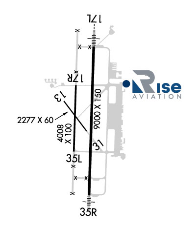
| Rwy | Rwy | |||||||
| 9000x150 | 9000' | 111.70 - 178° | 9000x150 | 9000' | ||||
| 4008x100 | 4008' | 4008x100 | 4008' | |||||
| Runway ID | Single Wheel | Double Wheel | Double Tandem Wheel | Dual Double Wheel |
| 18L/36R | 125,000 | 189,000 | 326,000 | N/A |
| 18R/36L | N/A | N/A | N/A | N/A |
| These numbers are Advisory and are not limits. The Airport Manager should have more accurate Weight Limits | ||||
 Airport Diagram might not be current. | |
| Facility Name: | NORTH TEXAS RGNL/PERRIN FLD |
| City Name: | SHERMAN/DENISON |
| County: | GRAYSON |
| State abbrev: | TX |
| State Name: | TEXAS |
| Ownership: | PUBLICLY OWNED |
| Use: | OPEN TO THE PUBLIC |
| Owner's Name: | GRAYSON COUNTY |
| Address: | COUNTY COURTHOUSE |
| SHERMAN, TX 75090 | |
| Owner's Phone: | 903-813-4228 |
| Manager's Name: | BILL MAGERS |
| Address: | 4700 AIRPORT DR |
| DENISON, TX 75020 | |
| Phone: | 903-786-2904 |
| FAA Region: | SOUTHWEST |
| FAA Field Office: | TEX |
| Date | Sunrise | Sunset |
|---|---|---|
| 04/25/24 Thursday | 6:43 | 20:06 |
| 04/26/24 Friday | 6:42 | 20:07 |
| 04/27/24 Saturday | 6:41 | 20:08 |
| 04/28/24 Sunday | 6:40 | 20:08 |
| 04/29/24 Monday | 6:39 | 20:09 |
| 04/30/24 Tuesday | 6:38 | 20:10 |
| 05/01/24 Wednesday | 6:37 | 20:11 |
| 05/02/24 Thursday | 6:36 | 20:11 |
| 05/03/24 Friday | 6:35 | 20:12 |
| 05/04/24 Saturday | 6:34 | 20:13 |
| 05/05/24 Sunday | 6:33 | 20:14 |
| 05/06/24 Monday | 6:32 | 20:14 |
| 05/07/24 Tuesday | 6:32 | 20:15 |
| 05/08/24 Wednesday | 6:31 | 20:16 |
| Airport Attendance Schedule | 7 Days A Week 0700-1900 |
| Airport Status | OPERATIONAL (This Status can change at any time - please check NOTAMS) |
| Airport Lighting Schedule | DUSK-DAWN. MIRL RWY 18L/36R PRESET LOW INTST; TO INCR INTST & ACTVT MALSR RWY 18L & MALS RWY 36R - CTAF. |
| Airport Storage Available | Tie Downs, Hanger |
| Extra Services Available | Flight Instruction |
| Wind Indicator | YES - (lighted) |
| Control Tower | YES |
| CTAF Frequency | 120.575 |
| Unicom Frequency | |
| Rotating Beacon Color | WG |
| Segmented Circle | YES |
| Landing Fee | NO |
| Airport Inspected | STATE - performed by PRIVATE CONTRACT PERSONNEL |
| Inspection Date | 11/08/2023 |
| Type of Fuel Available | Grade 100LL, JET A (freeze point -40C); -10100LL SELF SERVE. FOR FUEL AFT HRS CALL 903-786-2666; CALL-IN FEE. |
| Airframe Repair Service | MAJOR |
| Power Plant Repair Service | MAJOR |
| Latitude | N3342.8 |
| Longitude | W09640.4 (ESTIMATED) |
| Arpt Elevation | 749ft (SURVEYED) |
| Magnetic Variation | 03E |
| 4 miles W | of SHERMAN/DENISON |
| Traffic Pattern Altitude | |
| Sectional Chart | DALLAS-FT WORTH |
| Operations (Reported) | Yearly | Avg. Daily |
|---|---|---|
| General Aviation Transient | 35522 | 97 |
| General Aviation Local | 44099 | 121 |
| Air Taxi | 138 | 0 |
| Commerical | 0 | 0 |
| Commuter | 0 | 0 |
| Military | 209 | 1 |
| Aircraft based on Field | |
|---|---|
| General Aviation Singles | 115 |
| General Aviation Multi | 27 |
| Jet Aircraft | 11 |
| General Aviation Helicopters | 5 |
| Military Aircraft | 0 |
| Gliders | 2 |
| Ultralights | 0 |
| FSS on field | NO |
| FSS tie-in | FORT WORTH |
| FSS Phone | 1-800-WX-BRIEF |
| Who issues Notams | GYI |
| Notam D service at airport | YES |
| ARTCC Name | FORT WORTH |
| Airport Certification | |
| Aircraft Rescue & Firefighting Index | None |
| Airport of Entry | No |
| Custom Landing Rights | No |
| Joint Civil/Military | No |
| Military Landing rights | YES |
| NATIONAL PLAN OF INTEGRATED AIRPORT SYSTEMS (NPIAS) |
| GRANT AGREEMENTS UNDER FAAP/ADAP/AIP |
| SURPLUS PROPERTY AGREEMENT UNDER PUBLIC LAW 289 |
| ASSURANCES PURSUANT TO TITLE VI, CIVIL RIGHTS ACT OF 1964 |
| RWY 18L DSGND CALM WIND RWY. |
| TXY MKGS & HOLD LINES FADED. |
| FOR CD IF UNA TO CTC ON FSS FREQ, CTC FORT WORTH ARTCC AT 817-858-7584. |
Airport Communications & Frequencies:
| |||||||||||||||
| Runway: 18L | Runway: 36R | ||
| Mag heading: | 179° | Mag heading: | 359° |
| Rwy Slope: | .09% Up | Rwy Slope: | -.09% Down |
| Approach: | ILS | Approach: | |
| Pattern: | Left Traffic | Pattern: | Left Traffic |
| Markings: | PRECISION INSTRUMENT | Markings: | PRECISION INSTRUMENT |
| Marking Condition: | GOOD | Marking Condition: | GOOD |
| Arresting Dev: | Arresting Dev: | ||
| Lat & Long: | N3343.6 W09640.4 | Lat. & Long.: | N3342.1 W09640.4 |
| Elev: | 741.1 ft. MSL | Elev: | 748.9 ft. MSL |
| TCH: | 48 ft. AGL | TCH: | 51 ft. AGL |
| Visual Glide Path: | 3.00 degrees | Visual Glide Path: | 3.00 degrees |
| Displaced Threshold: | No | Displaced Threshold: | No |
| Touchdown Zone: | YES | Touchdown Zone: | YES |
| Touchdown Elev.: | 741.4 feet | Touchdown Elev.: | 749.3 feet |
| Visual Glide Slope: | 4-BOX VASI ON LEFT SIDE OF RUNWAY | Visual Glide Slope: | 4-BOX VASI ON LEFT SIDE OF RUNWAY |
| RVR Equipment: | RVR Equipment: | ||
| RVV Equipment: | NO | RVV Equipment: | NO |
| Approach Lights: | MALSR - 1,400 foot medium intensity approach lighting system with runway alignment indicator lights | Approach Lights: | MALS - 1,400 foot medium intensity approach lighting system |
| REIL: | NO | REIL: | NO |
| Centerline Lights: | NO | Centerline Lights: | NO |
| Touchdown lights: | NO | Touchdown lights: | NO |
| Runway Category: | Precision Instrument Runway | Runway Category: | D |
| Declared Distances: | Declared Distances: |
| Runway: 18R | Runway: 36L | ||
| Mag heading: | 179° | Mag heading: | 359° |
| Rwy Slope: | .20% Up | Rwy Slope: | -.20% Down |
| Approach: | Approach: | ||
| Pattern: | Left Traffic | Pattern: | Left Traffic |
| Markings: | BASIC | Markings: | BASIC |
| Marking Condition: | FAIR | Marking Condition: | FAIR |
| Arresting Dev: | Arresting Dev: | ||
| Lat & Long: | N3343.2 W09640.6 | Lat. & Long.: | N3342.5 W09640.6 |
| Elev: | 738.0 ft. MSL | Elev: | 746.0 ft. MSL |
| TCH: | TCH: | ||
| Visual Glide Path: | Visual Glide Path: | ||
| Displaced Threshold: | No | Displaced Threshold: | No |
| Touchdown Zone: | YES | Touchdown Zone: | YES |
| Touchdown Elev.: | 738.0 feet | Touchdown Elev.: | 746.0 feet |
| Visual Glide Slope: | Visual Glide Slope: | ||
| RVR Equipment: | RVR Equipment: | ||
| RVV Equipment: | NO | RVV Equipment: | NO |
| Approach Lights: | Approach Lights: | ||
| REIL: | NO | REIL: | NO |
| Centerline Lights: | NO | Centerline Lights: | NO |
| Touchdown lights: | NO | Touchdown lights: | NO |
| Runway Category: | Runway with a Visual Approach | Runway Category: | Runway with a Visual Approach |
| Declared Distances: | Declared Distances: |
Thanks for using FltPlan.com
all rights reserved © 1999-2024 by Flight Plan LLC