
| ALBUQUERQUE INTL SUNPORT ALBUQUERQUE NM |
| |
| Lat: N 3502.3 Long: W 10636.5 Elev: 5355 Var: -11 Longest Runway: 13793 | ||
| Clr Del: 119.2 Dept. ATIS: 118.0 Arr. ATIS: 118.0 Ground: 121.9 Tower: 120.3/123.77 | ||
| |||||||||||||||||||||||||||||||||||||||||||||||||||||||||||||||||||||
| |||||||||||||||||||||||||||||||||||||||||||||||||||||||||||||||||||||
| |||||||||||||||||||||||||||||||||||||||||||||||||||||||||||||||||||||
| |||||||||||||||||||||||||||||||||||||||||||||||||||||||||||||||||||||
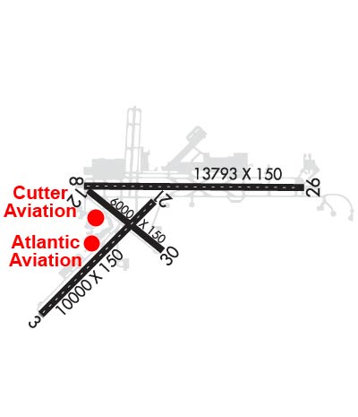
| Rwy | Rwy | |||||||
| 10000x150 | 10000' | 111.50 - 033° | 10000x150 | 10000' | ||||
| 13793x150 | 12793' | 111.90 - 079° | 13793x150 | 13793' | ||||
| 6000x150 | 6000' | 6000x150 | 6000' | |||||
| Runway ID | Single Wheel | Double Wheel | Double Tandem Wheel | Dual Double Wheel |
| 03/21 | 100,000 | 210,000 | 360,000 | 720,000 |
| 08/26 | 100,000 | 210,000 | 360,000 | 720,000 |
| 12/30 | 65,000 | 120,000 | 155,000 | N/A |
| These numbers are Advisory and are not limits. The Airport Manager should have more accurate Weight Limits | ||||
 Airport Diagram might not be current. | |
| Facility Name: | ALBUQUERQUE INTL SUNPORT |
| City Name: | ALBUQUERQUE |
| County: | BERNALILLO |
| State abbrev: | NM |
| State Name: | NEW MEXICO |
| Ownership: | PUBLICLY OWNED |
| Use: | OPEN TO THE PUBLIC |
| Owner's Name: | CITY OF ALBUQUERQUE |
| Address: | PO BOX 1293 |
| ALBUQUERQUE, NM 87103 | |
| Owner's Phone: | 505-768-3000 |
| Manager's Name: | RICHARD MCCURLEY; RICHARD MCCURLEY |
| Address: | PO BOX 9948 |
| ALBUQUERQUE, NM 87119 | |
| Phone: | 505-244-7700 |
| FAA Region: | SOUTHWEST |
| FAA Field Office: | LNM |
| Date | Sunrise | Sunset |
|---|---|---|
| 04/25/24 Thursday | 6:21 | 19:48 |
| 04/26/24 Friday | 6:20 | 19:49 |
| 04/27/24 Saturday | 6:19 | 19:49 |
| 04/28/24 Sunday | 6:18 | 19:50 |
| 04/29/24 Monday | 6:17 | 19:51 |
| 04/30/24 Tuesday | 6:16 | 19:52 |
| 05/01/24 Wednesday | 6:15 | 19:53 |
| 05/02/24 Thursday | 6:14 | 19:53 |
| 05/03/24 Friday | 6:13 | 19:54 |
| 05/04/24 Saturday | 6:12 | 19:55 |
| 05/05/24 Sunday | 6:11 | 19:56 |
| 05/06/24 Monday | 6:10 | 19:57 |
| 05/07/24 Tuesday | 6:09 | 19:58 |
| 05/08/24 Wednesday | 6:08 | 19:58 |
| Airport Attendance Schedule | CONTINUOUS |
| Airport Status | OPERATIONAL (This Status can change at any time - please check NOTAMS) |
| Airport Lighting Schedule | SS-SR |
| Airport Storage Available | Tie Downs, Hanger |
| Extra Services Available | Air Ambulance, Avionics, Cargo Handling, Charter, Flight Instruction, Aircraft Rental, Aircraft Sales, Annual Surveying |
| Wind Indicator | YES - (lighted) |
| Control Tower | YES |
| CTAF Frequency | |
| Unicom Frequency | 122.950 |
| Rotating Beacon Color | WG |
| Segmented Circle | NO |
| Landing Fee | NO |
| Airport Inspected | FEDERAL - performed by FAA AIRPORTS FIELD PERSONNEL |
| Inspection Date | 04/13/2023 |
| Type of Fuel Available | Grade 100LL, JET A (freeze point -40C), JET A-1 (freeze point -50C), JET A-1 (icing inhibitor, freeze point -50C) |
| Airframe Repair Service | MAJOR |
| Power Plant Repair Service | MAJOR |
| Latitude | N3502.3 |
| Longitude | W10636.5 (ESTIMATED) |
| Arpt Elevation | 5354ft (SURVEYED) |
| Magnetic Variation | 11E |
| 3 miles SE | of ALBUQUERQUE |
| Traffic Pattern Altitude | |
| Sectional Chart | ALBUQUERQUE |
| Operations (Reported) | Yearly | Avg. Daily |
|---|---|---|
| General Aviation Transient | 36073 | 99 |
| General Aviation Local | 16813 | 46 |
| Air Taxi | 24909 | 68 |
| Commerical | 45724 | 125 |
| Commuter | 0 | 0 |
| Military | 19120 | 52 |
| Aircraft based on Field | |
|---|---|
| General Aviation Singles | 38 |
| General Aviation Multi | 52 |
| Jet Aircraft | 55 |
| General Aviation Helicopters | 21 |
| Military Aircraft | 34 |
| Gliders | 0 |
| Ultralights | 0 |
| FSS on field | NO |
| FSS tie-in | ALBUQUERQUE |
| FSS Phone | 1-800-WX-BRIEF |
| Who issues Notams | ABQ |
| Notam D service at airport | YES |
| ARTCC Name | ALBUQUERQUE |
| Airport Certification | AIRPORT RECEIVING SCHEDULED AIR CARRIER SERVICE FROM CARRIERS CERTIFICATED BY THE CIVIL AERONAUTICS BOARD |
| Aircraft Rescue & Firefighting Index | AIRPORT HAS A CERTIFICATE UNDER CFR PART 139 |
| Airport of Entry | No |
| Custom Landing Rights | YES |
| Joint Civil/Military | No |
| Military Landing rights | YES |
| NATIONAL PLAN OF INTEGRATED AIRPORT SYSTEMS (NPIAS) |
| GRANT AGREEMENTS UNDER FAAP/ADAP/AIP |
| SURPLUS PROPERTY AGREEMENT UNDER PUBLIC LAW 289 |
| CONVEYANCE UNDER SCETION 16, FEDERAL AIRPORT ACT OF 1946 OR SECTION 23, AIRPORT AND AIRWAY DEVELOPMENT ACT OF 1970 |
| ASSURANCES PURSUANT TO TITLE VI, CIVIL RIGHTS ACT OF 1964 |
| AIR CARRIER GND HANDLING NOT AVBL BTN THE HRS OF 0100-0430. |
| BIRD HAZARD OCT-DEC & MAR-MAY. |
| TWY H MILITARY USE ONLY. |
| FTR ACFT DEP S ONLY. |
| DEPS ON RWY 03 ARE RSTRD AND RQR PRIOR COORDN WITH ATCT. |
| TWY E5 CLSD |
| SERVICE-FUEL: A++(MIL), A++100(MIL). |
| MIL WX SVC AVBL 1100-2300Z++ MON, TUE-FRI 1300-2300Z++. CLSD WKNDS & HOL/MIL DOWN DAYS. MSN WX SUPPORT BRIEFINGS FOR AIRCREW AVBL VIA THE 25 OWS/DAVIS-MONTHAN AFB DUR MIL WX FLT CLSD HR, DSN 228-6604M /C520-228-6604. WX FCST BY NWS KABQ. DSN 246-9707 AND C505-846-9707. H24 OBSN BY FAA C505-246-4200. |
| RWY 08 AND 12 APCH ENDS ARE DE-COUPLED. COMMON HOLD SHORT LINE IS SHARED. RWY 12 FOR TAKEOFF IS ONLY AVBL VIA TXY E. FULL LENGTH AVBL VIA BACK TAXI. RWY 30 LANDINGS, LAST AVBL EXIT IS TXY E, EXIT VIA E1 IS NOT POSSIBLE. |
| HVY STUDENT COPTER TFC; CTL FIRING AREA S OF ARPT. |
| ARFF PROVIDED BY USAF. |
| RWY 08/2 6 RWY 08/26, 03/21 & 12/30 GROOVED 130 FT WIDE. |
Airport Communications & Frequencies:
| |||||||||||||||||||||||||||||||||||||||||||||||||||||||
| Runway: 03 | Runway: 21 | ||
| Mag heading: | 34° | Mag heading: | 214° |
| Rwy Slope: | .11% Up | Rwy Slope: | -.11% Down |
| Approach: | ILS | Approach: | |
| Pattern: | Right Traffic | Pattern: | Left Traffic |
| Markings: | PRECISION INSTRUMENT | Markings: | PRECISION INSTRUMENT |
| Marking Condition: | GOOD | Marking Condition: | GOOD |
| Arresting Dev: | Arresting Dev: | ||
| Lat & Long: | N3501.3 W10637.8 | Lat. & Long.: | N3502.5 W10636.4 |
| Elev: | 5305.1 ft. MSL | Elev: | 5316.1 ft. MSL |
| TCH: | 59 ft. AGL | TCH: | 74 ft. AGL |
| Visual Glide Path: | 3.00 degrees | Visual Glide Path: | 3.00 degrees |
| Displaced Threshold: | No | Displaced Threshold: | No |
| Touchdown Zone: | YES | Touchdown Zone: | YES |
| Touchdown Elev.: | 5312.2 feet | Touchdown Elev.: | 5316.2 feet |
| Visual Glide Slope: | 4-Light PAPI on LEFT side of Runway | Visual Glide Slope: | 4-Light PAPI on LEFT side of Runway |
| RVR Equipment: | TOUCHDOWN-ROLLOUT | RVR Equipment: | TOUCHDOWN-ROLLOUT |
| RVV Equipment: | NO | RVV Equipment: | NO |
| Approach Lights: | MALSR - 1,400 foot medium intensity approach lighting system with runway alignment indicator lights | Approach Lights: | |
| REIL: | NO | REIL: | YES |
| Centerline Lights: | YES | Centerline Lights: | YES |
| Touchdown lights: | YES | Touchdown lights: | NO |
| Runway Category: | Precision Instrument Runway | Runway Category: | Runway with a Visual Approach |
| Declared Distances: | TORA:10000' TODA:10000' ASDA:10000' LDA:10000' | Declared Distances: | TORA:10000' TODA:10000' ASDA:10000' LDA:10000' |
| Runway: 08 | Runway: 26 | ||
| Mag heading: | 79° | Mag heading: | 259° |
| Rwy Slope: | .31% Up | Rwy Slope: | -.31% Down |
| Approach: | ILS/DME | Approach: | |
| Pattern: | Right Traffic | Pattern: | Left Traffic |
| Markings: | PRECISION INSTRUMENT | Markings: | PRECISION INSTRUMENT |
| Marking Condition: | GOOD | Marking Condition: | GOOD |
| Arresting Dev: | Arresting Dev: | ||
| Lat & Long: | N3502.7 W10637.3 | Lat. & Long.: | N3502.6 W10634.5 |
| Elev: | 5311.9 ft. MSL | Elev: | 5354.9 ft. MSL |
| TCH: | 55 ft. AGL | TCH: | 83 ft. AGL |
| Visual Glide Path: | 2.95 degrees | Visual Glide Path: | 3.00 degrees |
| Displaced Threshold: | 1000 feet | Displaced Threshold: | No |
| Touchdown Zone: | YES | Touchdown Zone: | YES |
| Touchdown Elev.: | 5319.9 feet | Touchdown Elev.: | 5354.9 feet |
| Visual Glide Slope: | 6-BOX VASI ON LEFT SIDE OF RUNWAY | Visual Glide Slope: | 4-Light PAPI on LEFT side of Runway; PAPI DOES NOT PROVIDE OBST CLEARANCE BYD 3.5 NM FROM THR, UNUSBL BYD 3.5 NM. |
| RVR Equipment: | TOUCHDOWN | RVR Equipment: | ROLLOUT |
| RVV Equipment: | NO | RVV Equipment: | NO |
| Approach Lights: | MALSR - 1,400 foot medium intensity approach lighting system with runway alignment indicator lights | Approach Lights: | |
| REIL: | NO | REIL: | YES |
| Centerline Lights: | YES | Centerline Lights: | YES |
| Touchdown lights: | YES | Touchdown lights: | NO |
| Runway Category: | Precision Instrument Runway | Runway Category: | Runway with a Visual Approach |
| Declared Distances: | TORA:13793' TODA:13793' ASDA:13793' LDA:12793' | Declared Distances: | TORA:13793' TODA:13793' ASDA:13793' LDA:13793' |
| Runway: 12 | Runway: 30 | ||
| Mag heading: | 118° | Mag heading: | 298° |
| Rwy Slope: | .02% Up | Rwy Slope: | -.02% Down |
| Approach: | Approach: | ||
| Pattern: | Right Traffic | Pattern: | Left Traffic |
| Markings: | BASIC | Markings: | BASIC |
| Marking Condition: | GOOD | Marking Condition: | GOOD |
| Arresting Dev: | Arresting Dev: | ||
| Lat & Long: | N3502.6 W10637.2 | Lat. & Long.: | N3502.0 W10636.3 |
| Elev: | 5312.4 ft. MSL | Elev: | 5313.6 ft. MSL |
| TCH: | TCH: | 46 ft. AGL | |
| Visual Glide Path: | Visual Glide Path: | 3.00 degrees | |
| Displaced Threshold: | No | Displaced Threshold: | No |
| Touchdown Zone: | YES | Touchdown Zone: | YES |
| Touchdown Elev.: | 5314.5 feet | Touchdown Elev.: | 5316.1 feet |
| Visual Glide Slope: | Visual Glide Slope: | 4-Light PAPI on LEFT side of Runway | |
| RVR Equipment: | ROLLOUT | RVR Equipment: | TOUCHDOWN |
| RVV Equipment: | NO | RVV Equipment: | NO |
| Approach Lights: | Approach Lights: | ||
| REIL: | NO | REIL: | YES |
| Centerline Lights: | NO | Centerline Lights: | NO |
| Touchdown lights: | NO | Touchdown lights: | NO |
| Runway Category: | Runway with a Visual Approach | Runway Category: | Runway with a Visual Approach |
| Declared Distances: | TORA:6000' TODA:6000' ASDA:6000' LDA:6000' | Declared Distances: | TORA:6000' TODA:6000' ASDA:6000' LDA:6000' |
Thanks for using FltPlan.com
all rights reserved © 1999-2024 by Flight Plan LLC


