
| ALBANY MUNI ALBANY MO |
| |
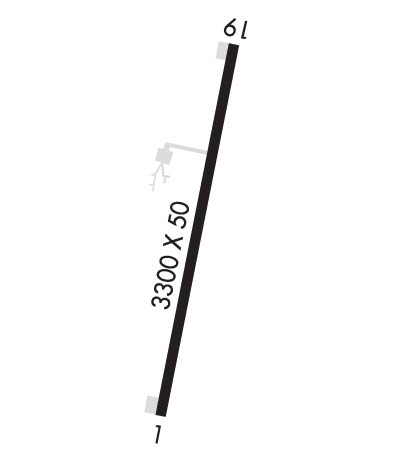
| Lat: N 4015.7 Long: W 09420.3 Elev: 891 Var: -05 Longest Runway: 3300 | ||
| CTAF: 122.9 | ||
| ||||||||||||||||||||||||||||||||||||||||||||
| ||||||||||||||||||||||||||||||||||||||||||||
| Rwy | Rwy | |||||||
| 3300x50 | 3300' | 3300x50 | 3300' | |||||
| Runway ID | Single Wheel | Double Wheel | Double Tandem Wheel | Dual Double Wheel |
| 01/19 | N/A | N/A | N/A | N/A |
| These numbers are Advisory and are not limits. The Airport Manager should have more accurate Weight Limits | ||||
| FltPlan does not have IFR approach charts available for KK19. |
 Airport Diagram might not be current. | |
| Facility Name: | ALBANY MUNI |
| City Name: | ALBANY |
| County: | GENTRY |
| State abbrev: | MO |
| State Name: | MISSOURI |
| Ownership: | PUBLICLY OWNED |
| Use: | OPEN TO THE PUBLIC |
| Owner's Name: | CITY OF ALBANY |
| Address: | 106 E CLAY |
| ALBANY, MO 64402 | |
| Owner's Phone: | 660-726-3935 |
| Manager's Name: | DEREK BROWN; GROUNDS KEEPER. |
| Address: | 106 E. CLAY |
| ALBANY, MO 64402 | |
| Phone: | 660-726-3935 |
| FAA Region: | CENTRAL |
| FAA Field Office: | NONE |
| Date | Sunrise | Sunset |
|---|---|---|
| 04/25/24 Thursday | 6:24 | 20:07 |
| 04/26/24 Friday | 6:22 | 20:08 |
| 04/27/24 Saturday | 6:21 | 20:09 |
| 04/28/24 Sunday | 6:20 | 20:10 |
| 04/29/24 Monday | 6:18 | 20:11 |
| 04/30/24 Tuesday | 6:17 | 20:12 |
| 05/01/24 Wednesday | 6:16 | 20:13 |
| 05/02/24 Thursday | 6:15 | 20:14 |
| 05/03/24 Friday | 6:13 | 20:15 |
| 05/04/24 Saturday | 6:12 | 20:16 |
| 05/05/24 Sunday | 6:11 | 20:17 |
| 05/06/24 Monday | 6:10 | 20:18 |
| 05/07/24 Tuesday | 6:09 | 20:19 |
| 05/08/24 Wednesday | 6:08 | 20:20 |
| Airport Attendance Schedule | UNATTENDED |
| Airport Status | OPERATIONAL (This Status can change at any time - please check NOTAMS) |
| Airport Lighting Schedule | |
| Airport Storage Available | NONE |
| Extra Services Available | NONE |
| Wind Indicator | YES - (lighted) |
| Control Tower | NO |
| CTAF Frequency | 122.900 |
| Unicom Frequency | |
| Rotating Beacon Color | |
| Segmented Circle | YES |
| Landing Fee | NO |
| Airport Inspected | STATE - performed by STATE AERONAUTICAL PERSONNEL |
| Inspection Date | 06/10/2021 |
| Type of Fuel Available | Grade 100LL; -10SELF SERVICE FUEL - 24 HRS. |
| Airframe Repair Service | None |
| Power Plant Repair Service | None |
| Latitude | N4015.7 |
| Longitude | W09420.3 (ESTIMATED) |
| Arpt Elevation | 891ft (ESTIMATED) |
| Magnetic Variation | 05E |
| 1 miles N | of ALBANY |
| Traffic Pattern Altitude | |
| Sectional Chart | OMAHA |
| Operations (Reported) | Yearly | Avg. Daily |
|---|---|---|
| General Aviation Transient | 950 | 3 |
| General Aviation Local | 2320 | 6 |
| Air Taxi | 0 | 0 |
| Commerical | 0 | 0 |
| Commuter | 0 | 0 |
| Military | 10 | 0 |
| Aircraft based on Field | |
|---|---|
| General Aviation Singles | 7 |
| General Aviation Multi | 1 |
| Jet Aircraft | 0 |
| General Aviation Helicopters | 0 |
| Military Aircraft | 0 |
| Gliders | 0 |
| Ultralights | 0 |
| FSS on field | NO |
| FSS tie-in | COLUMBIA |
| FSS Phone | 1-800-WX-BRIEF |
| Who issues Notams | COU |
| Notam D service at airport | YES |
| ARTCC Name | KANSAS CITY |
| Airport Certification | |
| Aircraft Rescue & Firefighting Index | None |
| Airport of Entry | No |
| Custom Landing Rights | No |
| Joint Civil/Military | No |
| Military Landing rights | YES |
| GRANT AGREEMENTS UNDER FAAP/ADAP/AIP |
| ASSURANCES PURSUANT TO TITLE VI, CIVIL RIGHTS ACT OF 1964 |
| WILDLIFE ON & INVOF ARPT. |
| FOR CD CTC KANSAS CITY ARTCC AT 913-254-8508. |
| RWY 01/1 9 RWY 01/19 VARIOUS THLD AND EDGE LGTS ARE BROKEN OR MISSING. |
| Runway: 01 | Runway: 19 | ||
| Mag heading: | N/A | Mag heading: | N/A |
| Rwy Slope: | .79% Up | Rwy Slope: | -.79% Down |
| Approach: | Approach: | ||
| Pattern: | Left Traffic | Pattern: | Right Traffic |
| Markings: | BASIC | Markings: | BASIC |
| Marking Condition: | GOOD | Marking Condition: | GOOD |
| Arresting Dev: | Arresting Dev: | ||
| Lat & Long: | N4015.5 W09420.4 | Lat. & Long.: | N4016.0 W09420.3 |
| Elev: | 865.3 ft. MSL | Elev: | 891.3 ft. MSL |
| TCH: | 43 ft. AGL | TCH: | 45 ft. AGL |
| Visual Glide Path: | 3.00 degrees | Visual Glide Path: | 3.00 degrees |
| Displaced Threshold: | No | Displaced Threshold: | No |
| Touchdown Zone: | NO | Touchdown Zone: | NO |
| Touchdown Elev.: | Touchdown Elev.: | ||
| Visual Glide Slope: | 2-Light PAPI on LEFT side of Runway | Visual Glide Slope: | 2-Light PAPI on LEFT side of Runway |
| RVR Equipment: | RVR Equipment: | ||
| RVV Equipment: | NO | RVV Equipment: | NO |
| Approach Lights: | Approach Lights: | ||
| REIL: | NO | REIL: | NO |
| Centerline Lights: | NO | Centerline Lights: | NO |
| Touchdown lights: | NO | Touchdown lights: | NO |
| Runway Category: | Runway with a Visual Approach | Runway Category: | Runway with a Visual Approach |
| Declared Distances: | Declared Distances: | ||
| Obstructions: | TREES | Obstructions: | FENCE |
| Marked: | NOT Marked/Lighted | Marked: | NOT Marked/Lighted |
| Clearance slope: | 14:1 | Clearance slope: | 9:1 |
| Obstruction height: | 44 feet AGL | Obstruction height: | 5 feet AGL |
| Dist. from runway: | 820 feet | Dist. from runway: | 245 feet |
| Centerline offset: | 200 right of centerline | Centerline offset: | 125 feet right of centerline |
| Comments: | +3-15 FT BRUSH, POST, SMALL TREES, FARM ROAD, 95-200 FT FM RWY END, 80-125 FT R. | Comments: |
Thanks for using FltPlan.com
all rights reserved © 1999-2024 by Flight Plan LLC
