| EASTERN SLOPE RGNL FRYEBURG ME |
| |
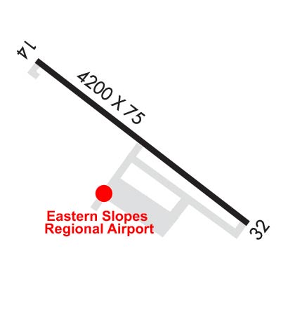
| Lat: N 4359.5 Long: W 07056.9 Elev: 455 Var: +17 Longest Runway: 4200 | ||
| AWOS: 135.77 CTAF: 122.8 | ||
| ||||||||||||||||||||||||||||||||||||||||||||||||||||||||||||||
| ||||||||||||||||||||||||||||||||||||||||||||||||||||||||||||||
| ||||||||||||||||||||||||||||||||||||||||||||||||||||||||||||||
| Rwy | Rwy | |||||||
| 4200x75 | 4200' | 4200x75 | 4200' | |||||
| Runway ID | Single Wheel | Double Wheel | Double Tandem Wheel | Dual Double Wheel |
| 14/32 | 30,000 | N/A | N/A | N/A |
| These numbers are Advisory and are not limits. The Airport Manager should have more accurate Weight Limits | ||||
 Airport Diagram might not be current. | |
| Facility Name: | EASTERN SLOPES RGNL |
| City Name: | FRYEBURG |
| County: | OXFORD |
| State abbrev: | ME |
| State Name: | MAINE |
| Ownership: | PUBLICLY OWNED |
| Use: | OPEN TO THE PUBLIC |
| Owner's Name: | EASTERN SLOPE REGIONAL APT AUTH |
| Address: | BOX 334 |
| FRYEBURG, ME 04037 | |
| Owner's Phone: | 207-935-4711 |
| Manager's Name: | DAVID CULLINAN |
| Address: | EASTERN SLOPE AIRPORT |
| FRYEBURG, ME 04037 | |
| Phone: | 207-890-7636; AMGR CELL: 207-890-7636. |
| FAA Region: | NEW ENGLAND |
| FAA Field Office: | NONE |
| Date | Sunrise | Sunset |
|---|---|---|
| 04/25/24 Thursday | 5:43 | 19:41 |
| 04/26/24 Friday | 5:42 | 19:42 |
| 04/27/24 Saturday | 5:40 | 19:43 |
| 04/28/24 Sunday | 5:39 | 19:44 |
| 04/29/24 Monday | 5:37 | 19:46 |
| 04/30/24 Tuesday | 5:36 | 19:47 |
| 05/01/24 Wednesday | 5:34 | 19:48 |
| 05/02/24 Thursday | 5:33 | 19:49 |
| 05/03/24 Friday | 5:32 | 19:50 |
| 05/04/24 Saturday | 5:30 | 19:51 |
| 05/05/24 Sunday | 5:29 | 19:53 |
| 05/06/24 Monday | 5:28 | 19:54 |
| 05/07/24 Tuesday | 5:26 | 19:55 |
| 05/08/24 Wednesday | 5:25 | 19:56 |
| Airport Attendance Schedule | 7 Days A Week 0800-1700 |
| Airport Status | OPERATIONAL (This Status can change at any time - please check NOTAMS) |
| Airport Lighting Schedule | ACTVT MIRL RWY 14/32 - CTAF. |
| Airport Storage Available | Tie Downs, Hanger |
| Extra Services Available | Charter, Flight Instruction, Aircraft Rental, Aircraft Sales |
| Wind Indicator | YES - (lighted) |
| Control Tower | NO |
| CTAF Frequency | 122.800 |
| Unicom Frequency | 122.800 |
| Rotating Beacon Color | WG |
| Segmented Circle | YES |
| Landing Fee | NO |
| Airport Inspected | STATE - performed by PRIVATE CONTRACT PERSONNEL |
| Inspection Date | 08/16/2021 |
| Type of Fuel Available | Grade 100LL, JET A; -1024 HR CREDIT CARD FUEL: FOR 100LL, CALL-OUT FEE; FOR JET A AFT HRS: 207-935-4711 -FBO. |
| Airframe Repair Service | MAJOR |
| Power Plant Repair Service | MAJOR |
| Latitude | N4359.5 |
| Longitude | W07056.9 (ESTIMATED) |
| Arpt Elevation | 454ft (SURVEYED) |
| Magnetic Variation | 17W |
| 3 miles SE | of FRYEBURG |
| Traffic Pattern Altitude | |
| Sectional Chart | NEW YORK |
| Operations (Reported) | Yearly | Avg. Daily |
|---|---|---|
| General Aviation Transient | 3500 | 10 |
| General Aviation Local | 4000 | 11 |
| Air Taxi | 200 | 1 |
| Commerical | 0 | 0 |
| Commuter | 0 | 0 |
| Military | 150 | 0 |
| Aircraft based on Field | |
|---|---|
| General Aviation Singles | 35 |
| General Aviation Multi | 2 |
| Jet Aircraft | 1 |
| General Aviation Helicopters | 0 |
| Military Aircraft | 0 |
| Gliders | 0 |
| Ultralights | 0 |
| FSS on field | NO |
| FSS tie-in | BANGOR |
| FSS Phone | 1-800-WX-BRIEF |
| Who issues Notams | IZG |
| Notam D service at airport | YES |
| ARTCC Name | BOSTON |
| Airport Certification | |
| Aircraft Rescue & Firefighting Index | None |
| Airport of Entry | No |
| Custom Landing Rights | No |
| Joint Civil/Military | No |
| Military Landing rights | YES |
| NATIONAL PLAN OF INTEGRATED AIRPORT SYSTEMS (NPIAS) |
| GRANT AGREEMENTS UNDER FAAP/ADAP/AIP |
| ASSURANCES PURSUANT TO TITLE VI, CIVIL RIGHTS ACT OF 1964 |
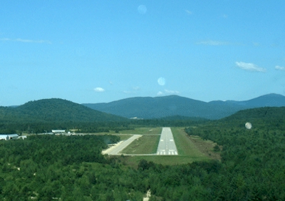
| OBSTN: LGTD HILLS IN APCH TO RWY 14, 4500 FT N, 7000 FT SW, 10000 FT NW. |
| BIRDS & DEER ON & INVOF ARPT. |
| FOR CD CTC PORTLAND APCH AT 207-874-7320, WHEN APCH CLSD CTC BOSTON ARTCC AT 603-879-6859. |
| COLD TEMPERATURE AIRPORT. ALTITUDE CORRECTION REQUIRED AT OR BELOW -29C. |
Airport Communications & Frequencies:
| |||||||||||||||||
| Runway: 14 | Runway: 32 | ||
| Mag heading: | 143° | Mag heading: | 323° |
| Rwy Slope: | -.82% Down | Rwy Slope: | .82% Up |
| Approach: | Approach: | ||
| Pattern: | Left Traffic | Pattern: | Left Traffic |
| Markings: | BASIC | Markings: | NONPRECISION INSTRUMENT |
| Marking Condition: | FAIR | Marking Condition: | FAIR |
| Arresting Dev: | Arresting Dev: | ||
| Lat & Long: | N4359.7 W07057.3 | Lat. & Long.: | N4359.3 W07056.5 |
| Elev: | 454.5 ft. MSL | Elev: | 420.2 ft. MSL |
| TCH: | TCH: | 17 ft. AGL | |
| Visual Glide Path: | Visual Glide Path: | 3.00 degrees | |
| Displaced Threshold: | No | Displaced Threshold: | No |
| Touchdown Zone: | YES | Touchdown Zone: | YES |
| Touchdown Elev.: | 454.6 feet | Touchdown Elev.: | 447.8 feet |
| Visual Glide Slope: | Visual Glide Slope: | 2-Box VASI on LEFT side of Runway; VASI UNUSBL BYD 7 DEGS L & R OF CNTRLN. | |
| RVR Equipment: | RVR Equipment: | ||
| RVV Equipment: | NO | RVV Equipment: | NO |
| Approach Lights: | Approach Lights: | ||
| REIL: | NO | REIL: | YES |
| Centerline Lights: | NO | Centerline Lights: | NO |
| Touchdown lights: | NO | Touchdown lights: | NO |
| Runway Category: | Runway with a Visual Approach | Runway Category: | Runway with a Non-precision Approach having visibility minimums greater than 3/4 mile |
| Declared Distances: | Declared Distances: | ||
| Obstructions: | Obstructions: | TREES | |
| Marked: | Marked: | NOT Marked/Lighted | |
| Clearance slope: | 20:1 | Clearance slope: | 33:1 |
| Obstruction height: | Obstruction height: | 55 feet AGL | |
| Dist. from runway: | Dist. from runway: | 2015 feet | |
| Centerline offset: | Centerline offset: | 200 feet left of centerline | |
| Comments: | Comments: |
Thanks for using FltPlan.com
all rights reserved © 1999-2024 by Flight Plan LLC