
| HOULTON INTL HOULTON ME |
| |
| Lat: N 4607.5 Long: W 06747.5 Elev: 489 Var: +18 Longest Runway: 5015 | ||
| CTAF: 122.8 | ||
| ||||||||||||||||||||||||||||||||||||||||||||
| ||||||||||||||||||||||||||||||||||||||||||||
| ||||||||||||||||||||||||||||||||||||||||||||
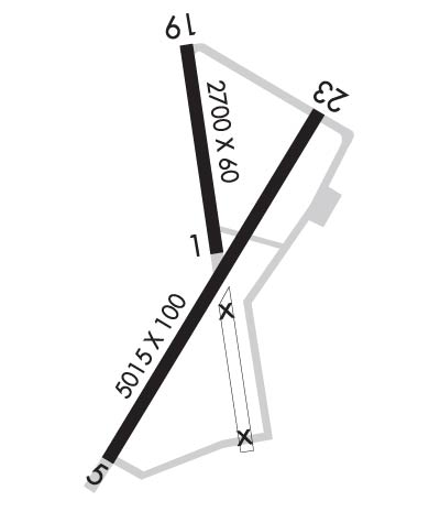
| Rwy | Rwy | |||||||
| 2700x60 | 2700' | 2700x60 | 2700' | |||||
| 5015x100 | 5015' | 5015x100 | 5015' | |||||
| Runway ID | Single Wheel | Double Wheel | Double Tandem Wheel | Dual Double Wheel |
| 01/19 | N/A | N/A | N/A | N/A |
| 05/23 | 30,000 | 57,000 | N/A | N/A |
| These numbers are Advisory and are not limits. The Airport Manager should have more accurate Weight Limits | ||||
 Airport Diagram might not be current. | |
| Facility Name: | HOULTON INTL |
| City Name: | HOULTON |
| County: | AROOSTOOK |
| State abbrev: | ME |
| State Name: | MAINE |
| Ownership: | PUBLICLY OWNED |
| Use: | OPEN TO THE PUBLIC |
| Owner's Name: | TOWN OF HOULTON |
| Address: | 21 WATER STREET |
| HOULTON, ME 04730 | |
| Owner's Phone: | 207-532-7111 |
| Manager's Name: | CHRISTOPHER STEWART; ALTN: 207-538-7997. |
| Address: | 21 WATER ST. |
| HOULTON, ME 04730 | |
| Phone: | (207) 532-1325 |
| FAA Region: | NEW ENGLAND |
| FAA Field Office: | NONE |
| Date | Sunrise | Sunset |
|---|---|---|
| 04/25/24 Thursday | 5:26 | 19:33 |
| 04/26/24 Friday | 5:25 | 19:34 |
| 04/27/24 Saturday | 5:23 | 19:35 |
| 04/28/24 Sunday | 5:21 | 19:37 |
| 04/29/24 Monday | 5:20 | 19:38 |
| 04/30/24 Tuesday | 5:18 | 19:39 |
| 05/01/24 Wednesday | 5:17 | 19:40 |
| 05/02/24 Thursday | 5:15 | 19:42 |
| 05/03/24 Friday | 5:14 | 19:43 |
| 05/04/24 Saturday | 5:12 | 19:44 |
| 05/05/24 Sunday | 5:11 | 19:46 |
| 05/06/24 Monday | 5:09 | 19:47 |
| 05/07/24 Tuesday | 5:08 | 19:48 |
| 05/08/24 Wednesday | 5:07 | 19:49 |
| Airport Attendance Schedule | MON-FRI 0700-1700, SAT-SUN UNATNDD |
| Airport Status | OPERATIONAL (This Status can change at any time - please check NOTAMS) |
| Airport Lighting Schedule | DUSK-DAWN. ACTVT REIL RWY 05 & 23; PAPI RWY 05; MIRL RWY 05/23 - CTAF. |
| Airport Storage Available | Tie Downs, Hanger |
| Extra Services Available | Air Ambulance |
| Wind Indicator | YES - (lighted) |
| Control Tower | NO |
| CTAF Frequency | 122.800 |
| Unicom Frequency | 122.800 |
| Rotating Beacon Color | WG |
| Segmented Circle | YES |
| Landing Fee | NO |
| Airport Inspected | STATE - performed by PRIVATE CONTRACT PERSONNEL |
| Inspection Date | 08/11/2021 |
| Type of Fuel Available | Grade 100LL, JET A (freeze point -40C), JET A; -10FOR JET A FUEL AFT HRS CALL 207-538-7997. 100 LL IS AVBL 24 HRS WITH MAJOR CREDIT CARD. |
| Airframe Repair Service | MAJOR |
| Power Plant Repair Service | MAJOR |
| Latitude | N4607.5 |
| Longitude | W06747.5 (ESTIMATED) |
| Arpt Elevation | 489ft (SURVEYED) |
| Magnetic Variation | 18W |
| 2 miles E | of HOULTON |
| Traffic Pattern Altitude | |
| Sectional Chart | HALIFAX |
| Operations (Reported) | Yearly | Avg. Daily |
|---|---|---|
| General Aviation Transient | 5000 | 14 |
| General Aviation Local | 7000 | 19 |
| Air Taxi | 0 | 0 |
| Commerical | 0 | 0 |
| Commuter | 0 | 0 |
| Military | 700 | 2 |
| Aircraft based on Field | |
|---|---|
| General Aviation Singles | 12 |
| General Aviation Multi | 3 |
| Jet Aircraft | 0 |
| General Aviation Helicopters | 0 |
| Military Aircraft | 0 |
| Gliders | 0 |
| Ultralights | 0 |
| FSS on field | NO |
| FSS tie-in | BANGOR |
| FSS Phone | 1-800-WX-BRIEF |
| Who issues Notams | HUL |
| Notam D service at airport | YES |
| ARTCC Name | BOSTON |
| Airport Certification | |
| Aircraft Rescue & Firefighting Index | None |
| Airport of Entry | YES |
| Custom Landing Rights | No |
| Joint Civil/Military | No |
| Military Landing rights | YES |
| NATIONAL PLAN OF INTEGRATED AIRPORT SYSTEMS (NPIAS) |
| GRANT AGREEMENTS UNDER FAAP/ADAP/AIP |
| SURPLUS PROPERTY AGREEMENT UNDER PUBLIC LAW 289 |
| SURPLUS PROPERTY AGREEMENT UNDER REGULATION 16-WAA |
| ASSURANCES PURSUANT TO TITLE VI, CIVIL RIGHTS ACT OF 1964 |
| AGREEMENT UNDER DLAND OR DCLA HAS EXPIRED. |
| USDA RECATERING FAC AVBL. |
| DEER ON & INVOF ARPT. |
| FOR AFT HRS ACES TO TRML BLDG USE FREQ 122.8. |
| FOR CD IF UNA TO CTC ON FSS FREQ, CTC BOSTON ARTCC AT 603-879-6859 . |
Airport Communications & Frequencies:
| |||||||||
| Runway: 01 | Runway: 19 | ||
| Mag heading: | 10° | Mag heading: | 190° |
| Rwy Slope: | .15% Up | Rwy Slope: | -.15% Down |
| Approach: | Approach: | ||
| Pattern: | Left Traffic | Pattern: | Left Traffic |
| Markings: | BASIC | Markings: | BASIC |
| Marking Condition: | POOR; FADED. | Marking Condition: | POOR; FADED. |
| Arresting Dev: | Arresting Dev: | ||
| Lat & Long: | N4607.4 W06747.5 | Lat. & Long.: | N4607.9 W06747.6 |
| Elev: | 473.8 ft. MSL | Elev: | 477.8 ft. MSL |
| TCH: | TCH: | ||
| Visual Glide Path: | Visual Glide Path: | ||
| Displaced Threshold: | No | Displaced Threshold: | No |
| Touchdown Zone: | YES | Touchdown Zone: | YES |
| Touchdown Elev.: | 477.9 feet | Touchdown Elev.: | 477.9 feet |
| Visual Glide Slope: | Visual Glide Slope: | ||
| RVR Equipment: | RVR Equipment: | ||
| RVV Equipment: | NO | RVV Equipment: | NO |
| Approach Lights: | Approach Lights: | ||
| REIL: | NO | REIL: | NO |
| Centerline Lights: | NO | Centerline Lights: | NO |
| Touchdown lights: | NO | Touchdown lights: | NO |
| Runway Category: | Runway with a Visual Approach | Runway Category: | Runway with a Visual Approach |
| Declared Distances: | Declared Distances: | ||
| Obstructions: | Obstructions: | POLE | |
| Marked: | Marked: | NOT Marked/Lighted | |
| Clearance slope: | 50:1 | Clearance slope: | 19:1 |
| Obstruction height: | Obstruction height: | 21 feet AGL | |
| Dist. from runway: | Dist. from runway: | 602 feet | |
| Centerline offset: | Centerline offset: | 112 feet left of centerline | |
| Comments: | Comments: |
| Runway: 05 | Runway: 23 | ||
| Mag heading: | 49° | Mag heading: | 229° |
| Rwy Slope: | .13% Up | Rwy Slope: | -.13% Down |
| Approach: | Approach: | ||
| Pattern: | Left Traffic | Pattern: | Left Traffic |
| Markings: | NONPRECISION INSTRUMENT | Markings: | NONPRECISION INSTRUMENT |
| Marking Condition: | GOOD | Marking Condition: | GOOD |
| Arresting Dev: | Arresting Dev: | ||
| Lat & Long: | N4607.0 W06747.8 | Lat. & Long.: | N4607.7 W06747.2 |
| Elev: | 483.0 ft. MSL | Elev: | 489.3 ft. MSL |
| TCH: | 43 ft. AGL | TCH: | |
| Visual Glide Path: | 3.00 degrees | Visual Glide Path: | |
| Displaced Threshold: | No | Displaced Threshold: | No |
| Touchdown Zone: | YES | Touchdown Zone: | YES |
| Touchdown Elev.: | 483.0 feet | Touchdown Elev.: | 489.4 feet |
| Visual Glide Slope: | 4-Light PAPI on LEFT side of Runway | Visual Glide Slope: | |
| RVR Equipment: | RVR Equipment: | ||
| RVV Equipment: | NO | RVV Equipment: | NO |
| Approach Lights: | Approach Lights: | ||
| REIL: | YES | REIL: | YES |
| Centerline Lights: | NO | Centerline Lights: | NO |
| Touchdown lights: | NO | Touchdown lights: | NO |
| Runway Category: | Runway with a Non-precision Approach having visibility minimums greater than 3/4 mile | Runway Category: | Runway with a Visual Approach |
| Declared Distances: | Declared Distances: | ||
| Obstructions: | Obstructions: | TREE | |
| Marked: | Marked: | NOT Marked/Lighted | |
| Clearance slope: | 34:1 | Clearance slope: | 16:1 |
| Obstruction height: | Obstruction height: | 14 feet AGL | |
| Dist. from runway: | Dist. from runway: | 430 feet | |
| Centerline offset: | Centerline offset: | 107 feet left of centerline | |
| Comments: | Comments: | BRUSH AT 66 FT FM RWY END, 178 FT R. |
Thanks for using FltPlan.com
all rights reserved © 1999-2024 by Flight Plan LLC
