| TERRE HAUTE INTL- HULMAN FLD TERRE HAUTE IN |
| |
| Lat: N 3927.0 Long: W 08718.4 Elev: 589 Var: +02 Longest Runway: 9021 | ||
| Dept. ATIS: 127.5 Arr. ATIS: 127.5 Ground: 121.6 Tower: 134.72 | ||
| ||||||||||||||||||||||||||||||||||||||||||||||||||||||||||||||||||||
| ||||||||||||||||||||||||||||||||||||||||||||||||||||||||||||||||||||
| ||||||||||||||||||||||||||||||||||||||||||||||||||||||||||||||||||||
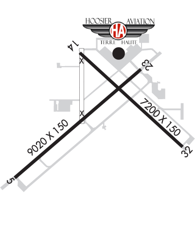
| Rwy | Rwy | |||||||
| 9021x150 | 9021' | 109.70 - 049° | 9021x150 | 9021' | ||||
| 7200x150 | 7200' | 7200x150 | 7200' | |||||
| Runway ID | Single Wheel | Double Wheel | Double Tandem Wheel | Dual Double Wheel |
| 05/23 | 75,000 | 200,000 | 300,000 | 600,000 |
| 14/32 | 75,000 | 200,000 | 300,000 | N/A |
| These numbers are Advisory and are not limits. The Airport Manager should have more accurate Weight Limits | ||||
 Airport Diagram might not be current. | |
| Facility Name: | TERRE HAUTE RGNL |
| City Name: | TERRE HAUTE |
| County: | VIGO |
| State abbrev: | IN |
| State Name: | INDIANA |
| Ownership: | PUBLICLY OWNED |
| Use: | OPEN TO THE PUBLIC |
| Owner's Name: | TERRE HAUTE RGNL ARPT AUTH |
| Address: | 581 S. AIRPORT ST. |
| TERRE HAUTE, IN 47803 | |
| Owner's Phone: | 812-877-2524 |
| Manager's Name: | JEFF HAUSER |
| Address: | 581 S. AIRPORT ST. |
| TERRE HAUTE, IN 47803 | |
| Phone: | 812-877-2524 |
| FAA Region: | GREAT LAKES |
| FAA Field Office: | CHI |
| Date | Sunrise | Sunset |
|---|---|---|
| 04/25/24 Thursday | 6:57 | 20:38 |
| 04/26/24 Friday | 6:56 | 20:39 |
| 04/27/24 Saturday | 6:54 | 20:40 |
| 04/28/24 Sunday | 6:53 | 20:41 |
| 04/29/24 Monday | 6:52 | 20:42 |
| 04/30/24 Tuesday | 6:51 | 20:43 |
| 05/01/24 Wednesday | 6:49 | 20:44 |
| 05/02/24 Thursday | 6:48 | 20:45 |
| 05/03/24 Friday | 6:47 | 20:46 |
| 05/04/24 Saturday | 6:46 | 20:47 |
| 05/05/24 Sunday | 6:45 | 20:48 |
| 05/06/24 Monday | 6:44 | 20:49 |
| 05/07/24 Tuesday | 6:43 | 20:49 |
| 05/08/24 Wednesday | 6:41 | 20:50 |
| Airport Attendance Schedule | CONTINUOUS |
| Airport Status | OPERATIONAL (This Status can change at any time - please check NOTAMS) |
| Airport Lighting Schedule | |
| Airport Storage Available | Tie Downs, Hanger |
| Extra Services Available | Air Freight, Cargo Handling, Flight Instruction, Aircraft Rental |
| Wind Indicator | YES - (lighted) |
| Control Tower | YES |
| CTAF Frequency | |
| Unicom Frequency | 122.950 |
| Rotating Beacon Color | WG |
| Segmented Circle | NO |
| Landing Fee | YES; LNDG FEE FOR CIVILIAN ACFT OVER 12,500 LBS. |
| Airport Inspected | FEDERAL - performed by FAA AIRPORTS FIELD PERSONNEL |
| Inspection Date | 09/20/2023 |
| Type of Fuel Available | Grade 100LL, JET A (freeze point -40C) |
| Airframe Repair Service | MAJOR |
| Power Plant Repair Service | MAJOR |
| Latitude | N3927.0 |
| Longitude | W08718.4 (ESTIMATED) |
| Arpt Elevation | 589ft (SURVEYED) |
| Magnetic Variation | 02W |
| 5 miles E | of TERRE HAUTE |
| Traffic Pattern Altitude | |
| Sectional Chart | ST LOUIS |
| Operations (Reported) | Yearly | Avg. Daily |
|---|---|---|
| General Aviation Transient | 28299 | 78 |
| General Aviation Local | 41021 | 112 |
| Air Taxi | 2701 | 7 |
| Commerical | 26 | 0 |
| Commuter | 0 | 0 |
| Military | 592 | 2 |
| Aircraft based on Field | |
|---|---|
| General Aviation Singles | 70 |
| General Aviation Multi | 7 |
| Jet Aircraft | 1 |
| General Aviation Helicopters | 0 |
| Military Aircraft | 0 |
| Gliders | 1 |
| Ultralights | 0 |
| FSS on field | NO |
| FSS tie-in | TERRE HAUTE |
| FSS Phone | 1-800-WX-BRIEF |
| Who issues Notams | HUF |
| Notam D service at airport | YES |
| ARTCC Name | INDIANAPOLIS |
| Airport Certification | CLSD TO SKED ACR OPS GTR THAN 9 PSGR SEATS. UNSKED ACR OPS GTR THAN 30 PSGR SEATS RQR PPR - CTC 812-877-2524 OR 812-877-2252. INDEX B ARFF CAPABILITY AVBL ON REQ. |
| Aircraft Rescue & Firefighting Index | AIRPORT HAS A CERTIFICATE UNDER CFR PART 139 |
| Airport of Entry | No |
| Custom Landing Rights | No; US CUSTOMS USER FEE ARPT. |
| Joint Civil/Military | No |
| Military Landing rights | YES |
| NATIONAL PLAN OF INTEGRATED AIRPORT SYSTEMS (NPIAS) |
| GRANT AGREEMENTS UNDER FAAP/ADAP/AIP |
| ASSURANCES PURSUANT TO TITLE VI, CIVIL RIGHTS ACT OF 1964 |
| AGREEMENT UNDER DLAND OR DCLA HAS EXPIRED. |
| BIRDS ON & INVOF ARPT. |
| ACFT SVCS AVBL 2200 & 0600 SUBJECT TO AFTER-HRS CALLOUT FEE. |
| RWY 05/2 3 1000 FT PAVED BLAST PAD SW END & 1325 FT PAVED BLAST PAD NE END; RY 32 400 FT BY 150 FT BLAST PAD; NOT AVBL FOR ASDA. |
Airport Communications & Frequencies:
| ||||||||||||||||||||||||||||||||||
| Runway: 05 | Runway: 23 | ||
| Mag heading: | 49° | Mag heading: | 229° |
| Rwy Slope: | .11% Up | Rwy Slope: | -.11% Down |
| Approach: | ILS | Approach: | |
| Pattern: | Left Traffic | Pattern: | Left Traffic |
| Markings: | PRECISION INSTRUMENT | Markings: | PRECISION INSTRUMENT |
| Marking Condition: | FAIR | Marking Condition: | FAIR |
| Arresting Dev: | Arresting Dev: | ||
| Lat & Long: | N3926.4 W08719.4 | Lat. & Long.: | N3927.4 W08718.0 |
| Elev: | 572.3 ft. MSL | Elev: | 582.2 ft. MSL |
| TCH: | 40 ft. AGL | TCH: | 50 ft. AGL |
| Visual Glide Path: | 3.00 degrees | Visual Glide Path: | 3.00 degrees |
| Displaced Threshold: | No | Displaced Threshold: | No |
| Touchdown Zone: | YES | Touchdown Zone: | YES |
| Touchdown Elev.: | 572.7 feet | Touchdown Elev.: | 582.3 feet |
| Visual Glide Slope: | 4-Light PAPI on LEFT side of Runway | Visual Glide Slope: | 4-Light PAPI on LEFT side of Runway |
| RVR Equipment: | TOUCHDOWN | RVR Equipment: | ROLLOUT |
| RVV Equipment: | NO | RVV Equipment: | NO |
| Approach Lights: | MALSR - 1,400 foot medium intensity approach lighting system with runway alignment indicator lights | Approach Lights: | |
| REIL: | NO | REIL: | YES |
| Centerline Lights: | NO | Centerline Lights: | NO |
| Touchdown lights: | NO | Touchdown lights: | NO |
| Runway Category: | Precision Instrument Runway | Runway Category: | D |
| Declared Distances: | TORA:9020' TODA:9020' ASDA:9020' LDA:9020' | Declared Distances: | TORA:9020' TODA:9020' ASDA:9020' LDA:9020' |
| Obstructions: | STACK | Obstructions: | TREE |
| Marked: | NOT Marked/Lighted | Marked: | NOT Marked/Lighted |
| Clearance slope: | 48:1 | Clearance slope: | 29:1 |
| Obstruction height: | 54 feet AGL | Obstruction height: | 71 feet AGL |
| Dist. from runway: | 2841 feet | Dist. from runway: | 2297 feet |
| Centerline offset: | 412 left of centerline | Centerline offset: | 535 feet right of centerline |
| Comments: | Comments: |
| Runway: 14 | Runway: 32 | ||
| Mag heading: | 137° | Mag heading: | 317° |
| Rwy Slope: | .29% Up | Rwy Slope: | -.29% Down |
| Approach: | Approach: | ||
| Pattern: | Left Traffic | Pattern: | Left Traffic |
| Markings: | NONPRECISION INSTRUMENT | Markings: | NONPRECISION INSTRUMENT |
| Marking Condition: | GOOD | Marking Condition: | GOOD |
| Arresting Dev: | Arresting Dev: | ||
| Lat & Long: | N3927.6 W08718.6 | Lat. & Long.: | N3926.7 W08717.5 |
| Elev: | 568.0 ft. MSL | Elev: | 589.1 ft. MSL |
| TCH: | 59 ft. AGL | TCH: | 84 ft. AGL |
| Visual Glide Path: | 2.75 degrees | Visual Glide Path: | 3.00 degrees |
| Displaced Threshold: | No | Displaced Threshold: | No |
| Touchdown Zone: | YES | Touchdown Zone: | YES |
| Touchdown Elev.: | 578.7 feet | Touchdown Elev.: | 589.2 feet |
| Visual Glide Slope: | 4-Light PAPI on LEFT side of Runway | Visual Glide Slope: | 4-Light PAPI on LEFT side of Runway |
| RVR Equipment: | RVR Equipment: | ||
| RVV Equipment: | NO | RVV Equipment: | NO |
| Approach Lights: | Approach Lights: | ||
| REIL: | YES | REIL: | YES |
| Centerline Lights: | NO | Centerline Lights: | NO |
| Touchdown lights: | NO | Touchdown lights: | NO |
| Runway Category: | Runway with a Non-precision Approach having visibility minimums greater than 3/4 mile | Runway Category: | Runway with a Non-precision Approach having visibility minimums greater than 3/4 mile |
| Declared Distances: | TORA:7200' TODA:7200' ASDA:7200' LDA:7200' | Declared Distances: | TORA:7200' TODA:7200' ASDA:7200' LDA:7200' |
| Obstructions: | TREE | Obstructions: | |
| Marked: | NOT Marked/Lighted | Marked: | |
| Clearance slope: | 22:1 | Clearance slope: | 50:1 |
| Obstruction height: | 105 feet AGL | Obstruction height: | |
| Dist. from runway: | 2597 feet | Dist. from runway: | |
| Centerline offset: | 341 left of centerline | Centerline offset: | |
| Comments: | Comments: |
Thanks for using FltPlan.com
all rights reserved © 1999-2024 by Flight Plan LLC