
| MONETT MUNI MONETT MO |
| |
| Lat: N 3654.3 Long: W 09400.8 Elev: 1316 Var: -02 Longest Runway: 6001 | ||
| Clr Del: 121.85 AWOS: 118.27 CTAF: 123.07 | ||
| ||||||
| ||||||
|
| Rwy | Rwy | |||||||
| 6001x100 | 6001' | 6001x100 | 6001' | |||||
| Runway ID | Single Wheel | Double Wheel | Double Tandem Wheel | Dual Double Wheel |
| 18/36 | 30,000 | N/A | N/A | N/A |
| These numbers are Advisory and are not limits. The Airport Manager should have more accurate Weight Limits | ||||
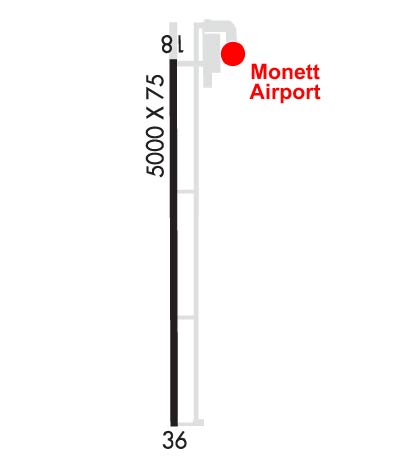 Airport Diagram might not be current. | |
| Facility Name: | MONETT RGNL |
| City Name: | MONETT |
| County: | BARRY |
| State abbrev: | MO |
| State Name: | MISSOURI |
| Ownership: | PUBLICLY OWNED |
| Use: | OPEN TO THE PUBLIC |
| Owner's Name: | CITY OF MONETT |
| Address: | 217 5TH - PO BOX 110 |
| MONETT, MO 65708 | |
| Owner's Phone: | 417-235-3763 |
| Manager's Name: | HOWARD FRAZIER; ARPT SUPERINTENDENT. |
| Address: | 1215 STATE HWY 97 |
| PIERCE CITY, MO 65723 | |
| Phone: | 417-476-5112 |
| FAA Region: | CENTRAL |
| FAA Field Office: | NONE |
| Date | Sunrise | Sunset |
|---|---|---|
| 05/03/24 Friday | 6:19 | 20:07 |
| 05/04/24 Saturday | 6:18 | 20:08 |
| 05/05/24 Sunday | 6:17 | 20:09 |
| 05/06/24 Monday | 6:16 | 20:10 |
| 05/07/24 Tuesday | 6:15 | 20:11 |
| 05/08/24 Wednesday | 6:14 | 20:12 |
| 05/09/24 Thursday | 6:13 | 20:13 |
| 05/10/24 Friday | 6:12 | 20:13 |
| 05/11/24 Saturday | 6:11 | 20:14 |
| 05/12/24 Sunday | 6:10 | 20:15 |
| 05/13/24 Monday | 6:09 | 20:16 |
| 05/14/24 Tuesday | 6:08 | 20:17 |
| 05/15/24 Wednesday | 6:08 | 20:18 |
| 05/16/24 Thursday | 6:07 | 20:19 |
| Airport Attendance Schedule | CONTINUOUS |
| Airport Status | OPERATIONAL (This Status can change at any time - please check NOTAMS) |
| Airport Lighting Schedule | ACTVT MALSR RWY 36; REIL RWY 18; HIRL RWY 18/36 - CTAF. PAPI RWY 18 & 36 ON CONSLY. |
| Airport Storage Available | Tie Downs, Hanger |
| Extra Services Available | Flight Instruction |
| Wind Indicator | YES - (unlit) |
| Control Tower | NO |
| CTAF Frequency | 123.075 |
| Unicom Frequency | 123.075; UNICOM IREG MNTD DURG DALGT HRS. |
| Rotating Beacon Color | WG |
| Segmented Circle | NO |
| Landing Fee | NO |
| Airport Inspected | STATE - performed by STATE AERONAUTICAL PERSONNEL |
| Inspection Date | 07/27/2023 |
| Type of Fuel Available | Grade 100LL, JET A (freeze point -40C); -10SELF-SERVE FUEL AVBL 24 HRS FOR 100LL ONLY. |
| Airframe Repair Service | MINOR; ACFT MAINT ON FLD. |
| Power Plant Repair Service | MAJOR |
| Latitude | N3654.3 |
| Longitude | W09400.8 (ESTIMATED) |
| Arpt Elevation | 1316ft (SURVEYED) |
| Magnetic Variation | 02E |
| 5 miles W | of MONETT |
| Traffic Pattern Altitude | |
| Sectional Chart | KANSAS CITY |
| Operations (Reported) | Yearly | Avg. Daily |
|---|---|---|
| General Aviation Transient | 9900 | 27 |
| General Aviation Local | 4500 | 12 |
| Air Taxi | 3600 | 10 |
| Commerical | 0 | 0 |
| Commuter | 0 | 0 |
| Military | 100 | 0 |
| Aircraft based on Field | |
|---|---|
| General Aviation Singles | 18 |
| General Aviation Multi | 4 |
| Jet Aircraft | 7 |
| General Aviation Helicopters | 1 |
| Military Aircraft | 0 |
| Gliders | 0 |
| Ultralights | 0 |
| FSS on field | NO |
| FSS tie-in | COLUMBIA |
| FSS Phone | 1-800-WX-BRIEF |
| Who issues Notams | COU |
| Notam D service at airport | YES |
| ARTCC Name | KANSAS CITY |
| Airport Certification | |
| Aircraft Rescue & Firefighting Index | None |
| Airport of Entry | No |
| Custom Landing Rights | No |
| Joint Civil/Military | No |
| Military Landing rights | No |
| NATIONAL PLAN OF INTEGRATED AIRPORT SYSTEMS (NPIAS) |
| SURPLUS PROPERTY AGREEMENT UNDER PUBLIC LAW 289 |
| ASSURANCES PURSUANT TO TITLE VI, CIVIL RIGHTS ACT OF 1964 |
| WILDLIFE & ULTRALIGHTS ON & INVOF ARPT. |
| 450 FT OF NORTH END OF ASPHALT TWY MARKED CLSD WITH LARGE YELLOW X'S. |
| FOR CD CTC SPRINGFIELD APCH AT 417-868-5620/5619. |
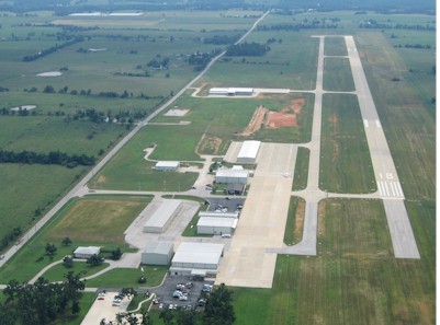
| RWY 18/3 6 RY 18/36 - 60 FT X 475 FT ASPH SAFETY AREA NORTH OF RY 18 THLD. |
| RWY 18/3 6 ASPH TWY SECTIONS NOT FULL STRENGTH. |
Airport Communications & Frequencies:
| ||||||||||||||||
| Runway: 18 | Runway: 36 | ||
| Mag heading: | 180° | Mag heading: | 0° |
| Rwy Slope: | -.31% Down | Rwy Slope: | .31% Up |
| Approach: | Approach: | ||
| Pattern: | Left Traffic | Pattern: | Left Traffic |
| Markings: | NONPRECISION INSTRUMENT | Markings: | PRECISION INSTRUMENT |
| Marking Condition: | FAIR | Marking Condition: | GOOD |
| Arresting Dev: | Arresting Dev: | ||
| Lat & Long: | N3654.8 W09400.8 | Lat. & Long.: | N3653.8 W09400.9 |
| Elev: | 1316.1 ft. MSL | Elev: | 1297.5 ft. MSL |
| TCH: | 43 ft. AGL | TCH: | 45 ft. AGL |
| Visual Glide Path: | 3.00 degrees | Visual Glide Path: | 3.00 degrees |
| Displaced Threshold: | No | Displaced Threshold: | No |
| Touchdown Zone: | YES | Touchdown Zone: | YES |
| Touchdown Elev.: | 1316.1 feet | Touchdown Elev.: | 1301.4 feet |
| Visual Glide Slope: | 4-Light PAPI on LEFT side of Runway | Visual Glide Slope: | 4-Light PAPI on LEFT side of Runway |
| RVR Equipment: | RVR Equipment: | ||
| RVV Equipment: | NO | RVV Equipment: | NO |
| Approach Lights: | Approach Lights: | MALSR - 1,400 foot medium intensity approach lighting system with runway alignment indicator lights | |
| REIL: | YES | REIL: | NO |
| Centerline Lights: | NO | Centerline Lights: | NO |
| Touchdown lights: | NO | Touchdown lights: | NO |
| Runway Category: | Runway with a Non-precision Approach having visibility minimums greater than 3/4 mile | Runway Category: | Runway with a Non-precision Approach having visibility minimums greater than 3/4 mile |
| Declared Distances: | Declared Distances: |
Thanks for using FltPlan.com
all rights reserved © 1999-2024 by Flight Plan LLC