
| GALION MUNI GALION OH |
| |
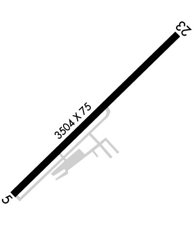
| Lat: N 4045.2 Long: W 08243.4 Elev: 1224 Var: +07 Longest Runway: 3504 | ||
| Clr Del: 126.8 CTAF: 122.8 | ||
| ||||||||||||||||||||||||||||||||||||||||||||
| ||||||||||||||||||||||||||||||||||||||||||||
| Rwy | Rwy | |||||||
| 3504x75 | 3318' | 3504x75 | 3504' | |||||
| Runway ID | Single Wheel | Double Wheel | Double Tandem Wheel | Dual Double Wheel |
| 05/23 | 12,000 | N/A | N/A | N/A |
| These numbers are Advisory and are not limits. The Airport Manager should have more accurate Weight Limits | ||||
 Airport Diagram might not be current. | |
| Facility Name: | GALION MUNI |
| City Name: | GALION |
| County: | RICHLAND; AND CRAWFORD CO. |
| State abbrev: | OH |
| State Name: | OHIO |
| Ownership: | PUBLICLY OWNED |
| Use: | OPEN TO THE PUBLIC |
| Owner's Name: | CITY OF GALION |
| Address: | 301 HARDING WAY E |
| GALION, OH 44833-2087 | |
| Owner's Phone: | 419-468-2818 |
| Manager's Name: | DR HOLBROOK RILES JR |
| Address: | 8240 STATE ROUTE 309 |
| GALION, OH 44833-9712 | |
| Phone: | 419-295-1821; FBO 419-565-3647. |
| FAA Region: | GREAT LAKES |
| FAA Field Office: | DET |
| Date | Sunrise | Sunset |
|---|---|---|
| 04/25/24 Thursday | 6:36 | 20:22 |
| 04/26/24 Friday | 6:35 | 20:23 |
| 04/27/24 Saturday | 6:34 | 20:24 |
| 04/28/24 Sunday | 6:32 | 20:25 |
| 04/29/24 Monday | 6:31 | 20:26 |
| 04/30/24 Tuesday | 6:30 | 20:27 |
| 05/01/24 Wednesday | 6:28 | 20:28 |
| 05/02/24 Thursday | 6:27 | 20:29 |
| 05/03/24 Friday | 6:26 | 20:30 |
| 05/04/24 Saturday | 6:25 | 20:31 |
| 05/05/24 Sunday | 6:24 | 20:32 |
| 05/06/24 Monday | 6:22 | 20:33 |
| 05/07/24 Tuesday | 6:21 | 20:34 |
| 05/08/24 Wednesday | 6:20 | 20:35 |
| Airport Attendance Schedule | MON-FRI 0800-1700 |
| Airport Status | OPERATIONAL (This Status can change at any time - please check NOTAMS) |
| Airport Lighting Schedule | ACTVT REIL RWY 05 & 23; PAPI RWY 05 & 23; MIRL RWY 05/23 - CTAF. |
| Airport Storage Available | Tie Downs, Hanger |
| Extra Services Available | Flight Instruction, Aircraft Rental |
| Wind Indicator | YES - (lighted) |
| Control Tower | NO |
| CTAF Frequency | 122.800 |
| Unicom Frequency | 122.800 |
| Rotating Beacon Color | WG |
| Segmented Circle | NO |
| Landing Fee | NO |
| Airport Inspected | STATE - performed by STATE AERONAUTICAL PERSONNEL |
| Inspection Date | 09/01/2021 |
| Type of Fuel Available | Grade 100LL, JET A (freeze point -40C); -10100LL AVBL H24 SELF SVC VIA CREDIT CARD.; -A FOR JET A AFT HRS CALL 419-565-3647. |
| Airframe Repair Service | MAJOR |
| Power Plant Repair Service | MAJOR |
| Latitude | N4045.2 |
| Longitude | W08243.4 (ESTIMATED) |
| Arpt Elevation | 1224ft (SURVEYED) |
| Magnetic Variation | 07W |
| 3 miles NE | of GALION |
| Traffic Pattern Altitude | |
| Sectional Chart | DETROIT |
| Operations (Reported) | Yearly | Avg. Daily |
|---|---|---|
| General Aviation Transient | 1800 | 5 |
| General Aviation Local | 4400 | 12 |
| Air Taxi | 0 | 0 |
| Commerical | 0 | 0 |
| Commuter | 0 | 0 |
| Military | 16 | 0 |
| Aircraft based on Field | |
|---|---|
| General Aviation Singles | 13 |
| General Aviation Multi | 0 |
| Jet Aircraft | 0 |
| General Aviation Helicopters | 0 |
| Military Aircraft | 0 |
| Gliders | 0 |
| Ultralights | 0 |
| FSS on field | NO |
| FSS tie-in | CLEVELAND |
| FSS Phone | 1-800-WX-BRIEF |
| Who issues Notams | CLE |
| Notam D service at airport | YES |
| ARTCC Name | CLEVELAND |
| Airport Certification | |
| Aircraft Rescue & Firefighting Index | None |
| Airport of Entry | No |
| Custom Landing Rights | No |
| Joint Civil/Military | No |
| Military Landing rights | YES |
| NATIONAL PLAN OF INTEGRATED AIRPORT SYSTEMS (NPIAS) |
| GRANT AGREEMENTS UNDER FAAP/ADAP/AIP |
| ASSURANCES PURSUANT TO TITLE VI, CIVIL RIGHTS ACT OF 1964 |
| STUDENT TRAINING ACTIVITY. |
| FOR CD CTC CLEVELAND APCH AT 216-352-2323, WHEN APCH CLSD CTC CLEVELAND ARTCC AT 440-774-0223/0490. |
Airport Communications & Frequencies:
| |||||||||||||||||||
| Runway: 05 | Runway: 23 | ||
| Mag heading: | 54° | Mag heading: | 234° |
| Rwy Slope: | -.11% Down | Rwy Slope: | .11% Up |
| Approach: | Approach: | ||
| Pattern: | Left Traffic | Pattern: | Left Traffic |
| Markings: | NONPRECISION INSTRUMENT | Markings: | NONPRECISION INSTRUMENT |
| Marking Condition: | GOOD | Marking Condition: | GOOD |
| Arresting Dev: | Arresting Dev: | ||
| Lat & Long: | N4045.0 W08243.7 | Lat. & Long.: | N4045.4 W08243.1 |
| Elev: | 1222.1 ft. MSL | Elev: | 1218.4 ft. MSL |
| TCH: | 31 ft. AGL | TCH: | 38 ft. AGL |
| Visual Glide Path: | 3.00 degrees | Visual Glide Path: | 3.00 degrees |
| Displaced Threshold: | 186 feet | Displaced Threshold: | No |
| Touchdown Zone: | YES | Touchdown Zone: | YES |
| Touchdown Elev.: | 1224.0 feet | Touchdown Elev.: | 1224.0 feet |
| Visual Glide Slope: | 4-Light PAPI on LEFT side of Runway | Visual Glide Slope: | 4-Light PAPI on LEFT side of Runway |
| RVR Equipment: | RVR Equipment: | ||
| RVV Equipment: | NO | RVV Equipment: | NO |
| Approach Lights: | Approach Lights: | ||
| REIL: | YES | REIL: | YES |
| Centerline Lights: | NO | Centerline Lights: | NO |
| Touchdown lights: | NO | Touchdown lights: | NO |
| Runway Category: | Runway with a Non-precision Approach | Runway Category: | Runway with a Non-precision Approach |
| Declared Distances: | Declared Distances: | ||
| Obstructions: | TREE | Obstructions: | CROPS |
| Marked: | NOT Marked/Lighted | Marked: | NOT Marked/Lighted |
| Clearance slope: | 13:1; APCH RATIO 18:1 TO DTHR. | Clearance slope: | 6:1 |
| Obstruction height: | 76 feet AGL | Obstruction height: | 2 feet AGL |
| Dist. from runway: | 1212 feet | Dist. from runway: | 213 feet |
| Centerline offset: | 305 right of centerline | Centerline offset: | |
| Comments: | Comments: |
Thanks for using FltPlan.com
all rights reserved © 1999-2024 by Flight Plan LLC
