| FLOYD BENNETT MEMORIAL GLENS FALLS NY |
| |
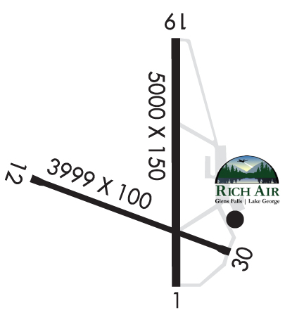
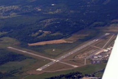
| Lat: N 4320.5 Long: W 07336.6 Elev: 328 Var: +14 Longest Runway: 5000 | ||
| AWOS: 119.92 CTAF: 123.0 | ||
| |||||||||||||||||||||||||||||||||||||||||||||||||||||||||||||||||||||
| |||||||||||||||||||||||||||||||||||||||||||||||||||||||||||||||||||||
| |||||||||||||||||||||||||||||||||||||||||||||||||||||||||||||||||||||
| Rwy | Rwy | |||||||
| 5000x150 | 5000' | 110.70 - 012° | 5000x150 | 5000' | ||||
| 3999x100 | 3999' | 3999x100 | 3999' | |||||
| Runway ID | Single Wheel | Double Wheel | Double Tandem Wheel | Dual Double Wheel |
| 01/19 | 80,000 | 110,000 | 180,000 | N/A |
| 12/30 | 39,000 | 53,000 | 76,000 | N/A |
| These numbers are Advisory and are not limits. The Airport Manager should have more accurate Weight Limits | ||||
 Airport Diagram might not be current. | |
| Facility Name: | FLOYD BENNETT MEML |
| City Name: | GLENS FALLS |
| County: | WARREN |
| State abbrev: | NY |
| State Name: | NEW YORK |
| Ownership: | PUBLICLY OWNED |
| Use: | OPEN TO THE PUBLIC |
| Owner's Name: | WARREN COUNTY |
| Address: | 4028 MAIN ST |
| WARRENSBURG, NY 12885-0010 | |
| Owner's Phone: | 518-824-8830 |
| Manager's Name: | ROBIN MAPP |
| Address: | 443 QUEENSBURY AVE, RM 201 |
| QUEENSBURY, NY 12804 | |
| Phone: | 518-792-5995 |
| FAA Region: | EASTERN |
| FAA Field Office: | NYC |
| Date | Sunrise | Sunset |
|---|---|---|
| 04/24/24 Wednesday | 5:57 | 19:49 |
| 04/25/24 Thursday | 5:55 | 19:50 |
| 04/26/24 Friday | 5:54 | 19:51 |
| 04/27/24 Saturday | 5:52 | 19:52 |
| 04/28/24 Sunday | 5:51 | 19:54 |
| 04/29/24 Monday | 5:49 | 19:55 |
| 04/30/24 Tuesday | 5:48 | 19:56 |
| 05/01/24 Wednesday | 5:46 | 19:57 |
| 05/02/24 Thursday | 5:45 | 19:58 |
| 05/03/24 Friday | 5:44 | 19:59 |
| 05/04/24 Saturday | 5:42 | 20:01 |
| 05/05/24 Sunday | 5:41 | 20:02 |
| 05/06/24 Monday | 5:40 | 20:03 |
| 05/07/24 Tuesday | 5:39 | 20:04 |
| Airport Attendance Schedule | 7 Days A Week 0800-1800 |
| Airport Status | OPERATIONAL (This Status can change at any time - please check NOTAMS) |
| Airport Lighting Schedule | ACTVT MALSR RWY 01; PAPI RWY 01, 19, 12, 30; HIRL RWY 01/19; MIRL RWY 12/30; TWY LGTS - CTAF. |
| Airport Storage Available | Tie Downs, Hanger |
| Extra Services Available | Cargo Handling, Charter, Flight Instruction, Aircraft Rental, Aircraft Sales |
| Wind Indicator | YES - (lighted) |
| Control Tower | NO |
| CTAF Frequency | 123.000 |
| Unicom Frequency | 123.000 |
| Rotating Beacon Color | WG |
| Segmented Circle | NO |
| Landing Fee | NO |
| Airport Inspected | FEDERAL - performed by FAA AIRPORTS FIELD PERSONNEL |
| Inspection Date | 05/04/2023 |
| Type of Fuel Available | Grade 100LL, JET A (freeze point -40C); -10SELF-SERVICE 100LL FUEL AVBL. FULL SERVICE FUELING AVBL AFTER HRS BY PRE-ARRANGEMENT; CALL 518-798-3091. |
| Airframe Repair Service | MAJOR |
| Power Plant Repair Service | MAJOR |
| Latitude | N4320.5 |
| Longitude | W07336.6 (ESTIMATED) |
| Arpt Elevation | 328ft (SURVEYED) |
| Magnetic Variation | 14W |
| 3 miles NE | of GLENS FALLS |
| Traffic Pattern Altitude | |
| Sectional Chart | NEW YORK |
| Operations (Reported) | Yearly | Avg. Daily |
|---|---|---|
| General Aviation Transient | 5372 | 15 |
| General Aviation Local | 9811 | 27 |
| Air Taxi | 7709 | 21 |
| Commerical | 0 | 0 |
| Commuter | 0 | 0 |
| Military | 467 | 1 |
| Aircraft based on Field | |
|---|---|
| General Aviation Singles | 42 |
| General Aviation Multi | 1 |
| Jet Aircraft | 2 |
| General Aviation Helicopters | 0 |
| Military Aircraft | 0 |
| Gliders | 0 |
| Ultralights | 0 |
| FSS on field | NO |
| FSS tie-in | BURLINGTON |
| FSS Phone | 1-800-WX-BRIEF |
| Who issues Notams | GFL |
| Notam D service at airport | YES |
| ARTCC Name | BOSTON |
| Airport Certification | PPR 48 HRS FOR ACFT OPS WITH MORE THAN 30 PAX SEATS CALL AMGR 518-792-5995. |
| Aircraft Rescue & Firefighting Index | AIRPORT HAS A CERTIFICATE UNDER CFR PART 139 |
| Airport of Entry | No |
| Custom Landing Rights | YES |
| Joint Civil/Military | No |
| Military Landing rights | YES |
| NATIONAL PLAN OF INTEGRATED AIRPORT SYSTEMS (NPIAS) |
| GRANT AGREEMENTS UNDER FAAP/ADAP/AIP |
| ASSURANCES PURSUANT TO TITLE VI, CIVIL RIGHTS ACT OF 1964 |
| AGREEMENT UNDER DLAND OR DCLA HAS EXPIRED. |
| RWYS12 & 19 APCHS OBSCURED FM ONE ANOTHER DUE TO HIGH GND. |
| PJE AIRSPACE DEFINED AS 5 NM RADIUS OF GFL. |
| COLD TEMPERATURE AIRPORT. ALTITUDE CORRECTION REQUIRED AT OR BELOW -19C. |
| FOR AFT HRS ACFT MAINT ASSISTANCE CALL 518-798-3091. |
| NOISE SENSITIVE AREA 1.5 MILES NORTH. |
| USE NBAA NOISE ABATEMENT PROCEDURES. |
| RCMD NO TOUCH AND GO OPS FM 2200Z-1200Z. |
| FOR CD CTC ALBANY APCH AT 518-862-2299. |
| FOUR OBSTN LGT POLES 1-1/2 MI TO 1-3/4 MI N OF RWY 19. |
| BIRDS/DEER ON & INVOF ARPT. |
| RWY 01 DSGND CALM WIND RWY. |
| GRASS CUTTING EQPT OPS ADJACENT TO ALL OPERATIONAL SFCS DALGT HRS MAY THRU OCT. |
| ULTRA-LIGHT ACT ON & INVOF ARPT. |
| ULTRA-LIGHT ACFT USE 500 FT AGL LEFT TFC FOR ALL RWYS. |
| DRG PDS OF SNOW REMOVAL OPNS NOV 1-APR 1 ACFT MUST CTC ARPT ON FREQ 123.0 10 MINS PRIOR TO LDG. |
| RSCD MAY NOT BE MONITORED OR REPORTED WHEN THE ARPT IS UNATNDD. |
| RWY 01/1 9 PCR VALUE: 635/F/B/X/T |
| RWY 12/3 0 PCR VALUE: 436/F/B/X/T |
Airport Communications & Frequencies:
| ||||||||||||||
| Runway: 01 | Runway: 19 | ||
| Mag heading: | 12° | Mag heading: | 192° |
| Rwy Slope: | .10% Up | Rwy Slope: | -.10% Down |
| Approach: | ILS | Approach: | |
| Pattern: | Left Traffic | Pattern: | Left Traffic |
| Markings: | PRECISION INSTRUMENT | Markings: | NONPRECISION INSTRUMENT |
| Marking Condition: | GOOD | Marking Condition: | GOOD |
| Arresting Dev: | Arresting Dev: | ||
| Lat & Long: | N4320.1 W07336.5 | Lat. & Long.: | N4321.0 W07336.6 |
| Elev: | 321.5 ft. MSL | Elev: | 326.5 ft. MSL |
| TCH: | 53 ft. AGL | TCH: | 50 ft. AGL |
| Visual Glide Path: | 3.00 degrees | Visual Glide Path: | 3.00 degrees |
| Displaced Threshold: | No | Displaced Threshold: | No |
| Touchdown Zone: | YES | Touchdown Zone: | YES |
| Touchdown Elev.: | 323.8 feet | Touchdown Elev.: | 326.6 feet |
| Visual Glide Slope: | 4-Light PAPI on LEFT side of Runway | Visual Glide Slope: | 4-Light PAPI on LEFT side of Runway |
| RVR Equipment: | RVR Equipment: | ||
| RVV Equipment: | NO | RVV Equipment: | NO |
| Approach Lights: | MALSR - 1,400 foot medium intensity approach lighting system with runway alignment indicator lights | Approach Lights: | |
| REIL: | NO | REIL: | NO |
| Centerline Lights: | NO | Centerline Lights: | NO |
| Touchdown lights: | NO | Touchdown lights: | NO |
| Runway Category: | Precision Instrument Runway | Runway Category: | Runway with a Non-precision Approach having visibility minimums greater than 3/4 mile |
| Declared Distances: | TORA:5000' TODA:5000' ASDA:5000' LDA:5000' | Declared Distances: | TORA:5000' TODA:5000' ASDA:5000' LDA:5000' |
| Obstructions: | Obstructions: | TREES | |
| Marked: | Marked: | NOT Marked/Lighted | |
| Clearance slope: | 34:1 | Clearance slope: | 26:1 |
| Obstruction height: | Obstruction height: | 57 feet AGL | |
| Dist. from runway: | Dist. from runway: | 1715 feet | |
| Centerline offset: | Centerline offset: | 315 feet right of centerline | |
| Comments: | Comments: |
| Runway: 12 | Runway: 30 | ||
| Mag heading: | 124° | Mag heading: | 304° |
| Rwy Slope: | -.11% Down | Rwy Slope: | .11% Up |
| Approach: | Approach: | ||
| Pattern: | Left Traffic | Pattern: | Left Traffic |
| Markings: | NONPRECISION INSTRUMENT | Markings: | NONPRECISION INSTRUMENT |
| Marking Condition: | GOOD | Marking Condition: | GOOD |
| Arresting Dev: | Arresting Dev: | ||
| Lat & Long: | N4320.5 W07337.1 | Lat. & Long.: | N4320.3 W07336.3 |
| Elev: | 328.4 ft. MSL | Elev: | 324.1 ft. MSL |
| TCH: | 55 ft. AGL | TCH: | 45 ft. AGL |
| Visual Glide Path: | 3.85 degrees | Visual Glide Path: | 3.00 degrees |
| Displaced Threshold: | No | Displaced Threshold: | No |
| Touchdown Zone: | YES | Touchdown Zone: | YES |
| Touchdown Elev.: | 328.4 feet | Touchdown Elev.: | 325.3 feet |
| Visual Glide Slope: | 4-Light PAPI on LEFT side of Runway | Visual Glide Slope: | 4-Light PAPI on LEFT side of Runway |
| RVR Equipment: | RVR Equipment: | ||
| RVV Equipment: | NO | RVV Equipment: | NO |
| Approach Lights: | Approach Lights: | ||
| REIL: | NO | REIL: | NO |
| Centerline Lights: | NO | Centerline Lights: | NO |
| Touchdown lights: | NO | Touchdown lights: | NO |
| Runway Category: | Runway with a Non-precision Approach having visibility minimums greater than 3/4 mile | Runway Category: | Runway with a Non-precision Approach having visibility minimums greater than 3/4 mile |
| Declared Distances: | TORA:3999' TODA:3999' ASDA:3999' LDA:3999' | Declared Distances: | TORA:3999' TODA:3999' ASDA:3999' LDA:3999' |
| Obstructions: | TREES | Obstructions: | TREES |
| Marked: | NOT Marked/Lighted | Marked: | NOT Marked/Lighted |
| Clearance slope: | 19:1 | Clearance slope: | 23:1 |
| Obstruction height: | 147 feet AGL | Obstruction height: | 71 feet AGL |
| Dist. from runway: | 2885 feet | Dist. from runway: | 1870 feet |
| Centerline offset: | 567 left of centerline | Centerline offset: | |
| Comments: | Comments: |
Thanks for using FltPlan.com
all rights reserved © 1999-2024 by Flight Plan LLC