| ROSTRAVER MONONGAHELA PA |
| |
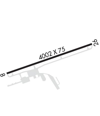
| Lat: N 4012.6 Long: W 07949.9 Elev: 1228 Var: +09 Longest Runway: 4002 | ||
| AWOS: 118.47 CTAF: 122.8 | ||
| |||||||||||||||||||||||
| |||||||||||||||||||||||
| |||||||||||||||||||||||
| Rwy | Rwy | |||||||
| 4002x75 | 4002' | 4002x75 | 4002' | |||||
| Runway ID | Single Wheel | Double Wheel | Double Tandem Wheel | Dual Double Wheel |
| 08/26 | 26,000 | 30,000 | N/A | N/A |
| These numbers are Advisory and are not limits. The Airport Manager should have more accurate Weight Limits | ||||
 Airport Diagram might not be current. | |
| Facility Name: | ROSTRAVER |
| City Name: | MONONGAHELA |
| County: | WESTMORELAND |
| State abbrev: | PA |
| State Name: | PENNSYLVANIA |
| Ownership: | PUBLICLY OWNED |
| Use: | OPEN TO THE PUBLIC |
| Owner's Name: | WESTMORELAND CO ARPT AUTH |
| Address: | 148 AVIATION LANE, SUITE 103 |
| LATROBE, PA 15650 | |
| Owner's Phone: | 724-539-8100 |
| Manager's Name: | GABE MONZO |
| Address: | 605 AIRPORT RD |
| BELLE VERNON, PA 15012 | |
| Phone: | 724-379-6980 |
| FAA Region: | EASTERN |
| FAA Field Office: | HAR |
| Date | Sunrise | Sunset |
|---|---|---|
| 04/25/24 Thursday | 6:26 | 20:09 |
| 04/26/24 Friday | 6:24 | 20:10 |
| 04/27/24 Saturday | 6:23 | 20:11 |
| 04/28/24 Sunday | 6:22 | 20:12 |
| 04/29/24 Monday | 6:21 | 20:13 |
| 04/30/24 Tuesday | 6:19 | 20:14 |
| 05/01/24 Wednesday | 6:18 | 20:15 |
| 05/02/24 Thursday | 6:17 | 20:16 |
| 05/03/24 Friday | 6:16 | 20:17 |
| 05/04/24 Saturday | 6:14 | 20:18 |
| 05/05/24 Sunday | 6:13 | 20:19 |
| 05/06/24 Monday | 6:12 | 20:20 |
| 05/07/24 Tuesday | 6:11 | 20:21 |
| 05/08/24 Wednesday | 6:10 | 20:22 |
| Airport Attendance Schedule | MON - FRI 0700 - 1700; AFT HRS CTC 724-640-6349/2409. |
| Airport Status | OPERATIONAL (This Status can change at any time - please check NOTAMS) |
| Airport Lighting Schedule | ACTVT REIL RWY 08/26; MIRL RWY 08/26 - CTAF. |
| Airport Storage Available | Tie Downs, Hanger |
| Extra Services Available | Air Ambulance, Avionics, Aircraft Sales |
| Wind Indicator | YES - (lighted) |
| Control Tower | NO |
| CTAF Frequency | 122.800 |
| Unicom Frequency | 122.800 |
| Rotating Beacon Color | WG |
| Segmented Circle | YES |
| Landing Fee | NO |
| Airport Inspected | STATE - performed by STATE AERONAUTICAL PERSONNEL |
| Inspection Date | 02/14/2024 |
| Type of Fuel Available | Grade 100LL, JET A (freeze point -40C), JET A |
| Airframe Repair Service | MAJOR |
| Power Plant Repair Service | MAJOR |
| Latitude | N4012.6 |
| Longitude | W07949.9 (ESTIMATED) |
| Arpt Elevation | 1228ft (SURVEYED) |
| Magnetic Variation | 09W |
| 5 miles E | of MONONGAHELA |
| Traffic Pattern Altitude | |
| Sectional Chart | DETROIT |
| Operations (Reported) | Yearly | Avg. Daily |
|---|---|---|
| General Aviation Transient | 18900 | 52 |
| General Aviation Local | 24000 | 66 |
| Air Taxi | 900 | 2 |
| Commerical | 0 | 0 |
| Commuter | 0 | 0 |
| Military | 120 | 0 |
| Aircraft based on Field | |
|---|---|
| General Aviation Singles | 40 |
| General Aviation Multi | 4 |
| Jet Aircraft | 0 |
| General Aviation Helicopters | 0 |
| Military Aircraft | 0 |
| Gliders | 1 |
| Ultralights | 0 |
| FSS on field | NO |
| FSS tie-in | ALTOONA |
| FSS Phone | 1-800-WX-BRIEF |
| Who issues Notams | AOO |
| Notam D service at airport | YES |
| ARTCC Name | CLEVELAND |
| Airport Certification | |
| Aircraft Rescue & Firefighting Index | None |
| Airport of Entry | No |
| Custom Landing Rights | No |
| Joint Civil/Military | No |
| Military Landing rights | YES |
| NATIONAL PLAN OF INTEGRATED AIRPORT SYSTEMS (NPIAS) |
| GRANT AGREEMENTS UNDER FAAP/ADAP/AIP |
| ASSURANCES PURSUANT TO TITLE VI, CIVIL RIGHTS ACT OF 1964 |
| DEER & BIRDS ON & INVOF ARPT. |
| FOR CD CTC PITTSBURGH APCH AT 412-472-5591. |
Airport Communications & Frequencies:
| ||||||||||||||||||
| Runway: 08 | Runway: 26 | ||
| Mag heading: | 76° | Mag heading: | 256° |
| Rwy Slope: | -.13% Down | Rwy Slope: | .13% Up |
| Approach: | Approach: | ||
| Pattern: | Left Traffic; RIGHT TRAFFIC HELICOPTERS/ULTRALIGHTS. | Pattern: | Left Traffic; RIGHT TRAFFIC HELICOPTERS/ULTRALIGHTS. |
| Markings: | NONPRECISION INSTRUMENT | Markings: | NONPRECISION INSTRUMENT |
| Marking Condition: | FAIR | Marking Condition: | FAIR |
| Arresting Dev: | Arresting Dev: | ||
| Lat & Long: | N4012.5 W07950.3 | Lat. & Long.: | N4012.7 W07949.5 |
| Elev: | 1228.1 ft. MSL | Elev: | 1222.8 ft. MSL |
| TCH: | 51 ft. AGL | TCH: | 48 ft. AGL |
| Visual Glide Path: | 3.00 degrees | Visual Glide Path: | 3.00 degrees |
| Displaced Threshold: | No | Displaced Threshold: | No |
| Touchdown Zone: | YES | Touchdown Zone: | YES |
| Touchdown Elev.: | 1228.2 feet | Touchdown Elev.: | 1223.7 feet |
| Visual Glide Slope: | 4-BOX VASI ON RIGHT SIDE OF RUNWAY | Visual Glide Slope: | 4-BOX VASI ON LEFT SIDE OF RUNWAY |
| RVR Equipment: | RVR Equipment: | ||
| RVV Equipment: | NO | RVV Equipment: | NO |
| Approach Lights: | Approach Lights: | ||
| REIL: | YES | REIL: | YES |
| Centerline Lights: | NO | Centerline Lights: | NO |
| Touchdown lights: | NO | Touchdown lights: | NO |
| Runway Category: | Runway with a Non-precision Approach having visibility minimums greater than 3/4 mile | Runway Category: | Runway with a Non-precision Approach having visibility minimums greater than 3/4 mile |
| Declared Distances: | Declared Distances: | ||
| Obstructions: | TOWER | Obstructions: | |
| Marked: | NOT Marked/Lighted | Marked: | |
| Clearance slope: | 31:1 | Clearance slope: | 34:1 |
| Obstruction height: | 127 feet AGL | Obstruction height: | |
| Dist. from runway: | 4215 feet | Dist. from runway: | |
| Centerline offset: | 245 right of centerline | Centerline offset: | |
| Comments: | Comments: |
Thanks for using FltPlan.com
all rights reserved © 1999-2024 by Flight Plan LLC