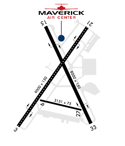
KFSD

JOE FOSS FIELD       SIOUX FALLS       SD
  Time Zone: Central 
Lat: N 4334.9     Long: W 09644.5    Elev: 1430     Var: -05  Longest Runway: 9000
    Dept. ATIS: 126.6     Arr. ATIS: 126.6     AWOS: 126.6   Ground: 121.9     Tower: 118.3

FBO & Flight Services info for KFSD

FBOs: Update your Fuel Prices

  click here  
No ramp fees. No security fees. Offering an array of professional line services & amenities including competitive fuel pricing, ground handling, quick-turns, hangar storage, catering, concierge, ground transport, flight planning room, pilot's lounge & conference room. Whether you're here for business or pleasure, we'll do our best to ensure your visit is as enjoyable as possible. Open 24/7.
Ph: 605-312-5680 Fax: 605-271-6387 Freq: 122.77WebsiteE-Mail
                     
Service
Jet
100LL
80/87
MoGas
Fuel Avail: 24 Hours a Day
Full5.736.49    Last Update: 04/04/2024 21:50
PRICES GUARANTEED by FBO.
Self        
Misc. Info: CAA ACCEPTED! No Ramp Fees No Facility Fees, Unicom Frequency is 122.775Address: 4201 N. MAVERICK PLACE,   SIOUX FALLS, SD 57104-0197

SIGNATUREPh: 605-336-7791 Fax: 605-373-0665 Freq: 122.95
Service
Jet
100LL
80/87
MoGas
Fuel Avail: Prist+ $0.08/gal
Full5.936.50    Last Update: 04/25/2024 09:46  
 Address: 3501 AVIATION AVENUE,   SIOUX FALLS, SD 57104
ASOSPh: 605-331-7833
-
Freq: 126.6  
If you are an FBO, call 1-203-262-8900 to update your info or email: Support@FltPlan.com
Advertise your FBO on FltPlan.com
FBOs at nearby airports who want your business:
KFAR


  click here  
A Great Alternative to KFSD! Open 24/7, US Customs at our facility, Jet A, 100LL, competitive fuel pricing, Quick Turns, Pilots Choice Award Recipient, Recognized for Uncompromising Standards of Quality & Excellence of Service, Competitive Fuel Pricing, Quick Turns, Large Hangars up to Global/G650, Hertz on site, Avtrip Points on every gallon. www.whyfargo.com
Ph: 1-800-770-0538WebsiteE-Mail Fax: 1-701-237-6887 Freq: 130.52

Runway & Approach Info for KFSD
Rwy
Length
Land Dist**
Approach*
  Rwy
Length
Land Dist**
Approach*
03
9000x150  9000'          
ILS
 109.90 - 029°  
  
21
  9000x150  9000'          
ILS
 111.10 - 209°  
09
3151x75  3151'          
 
  
27
  3151x75  3151'          
 
15
8000x150  8000'          
 
  
33
  8000x150  8000'          
 
 * only ILS, LOC, LDA, and SDF approaches to a specific runway are shown
** For any Declared Landing Distance Available, please see A/FD or Approach plates
Runway Weight Capability (lbs.) Help
Runway IDSingle WheelDouble WheelDouble Tandem WheelDual Double Wheel
03/21200,000200,000444,000N/A
09/2730,000N/AN/AN/A
15/33100,000180,000400,000N/A
H1N/AN/AN/AN/A
These numbers are Advisory and are not limits.   The Airport Manager should have more accurate Weight Limits
Please email Support@FltPlan.com for further information.
Approach Charts
Approaches    
Current Weather/Notams
Customs Information Send updates to Support@FltPlan.com
Phone 605-338-4384
Fax N/A

Comments Mon-Fri 0800-1600 *2 hrs advance notice required *Call prior to 1600 on preceding weekday. *Weekend arrivals call prior to 1600 on preceeding Friday
Database effective 05/16/2024
Airport Diagram of KFSD
Airport Diagram might not be current.

Facility Name: JOE FOSS FLD
City Name: SIOUX FALLS
County: MINNEHAHA
State abbrev: SD
State Name: SOUTH DAKOTA
   
Ownership: PUBLICLY OWNED
Use: OPEN TO THE PUBLIC
Owner's Name: SIOUX FALLS REGNL ARPT AUTH
Address: 2801 JAYCEE LANE
 SIOUX FALLS, SD 57104
Owner's Phone: 605-336-0762
  
Manager's Name: DANIEL J. LETELLIER
Address: 2801 JAYCEE LANE
 SIOUX FALLS, SD 57104
Phone: 605-336-0762
   
FAA Region: GREAT LAKES
FAA Field Office: DMA


Sunrise / Sunset times for JOE FOSS FLD

DateSunriseSunset
04/24/24 Wednesday6:2920:22
04/25/24 Thursday6:2720:23
04/26/24 Friday6:2620:24
04/27/24 Saturday6:2420:26
04/28/24 Sunday6:2320:27
04/29/24 Monday6:2120:28
04/30/24 Tuesday6:2020:29
05/01/24 Wednesday6:1820:30
05/02/24 Thursday6:1720:31
05/03/24 Friday6:1620:33
05/04/24 Saturday6:1420:34
05/05/24 Sunday6:1320:35
05/06/24 Monday6:1220:36
05/07/24 Tuesday6:1020:37

Airport Facilities

Airport Attendance ScheduleCONTINUOUS
Airport Status OPERATIONAL (This Status can change at any time - please check NOTAMS)
Airport Lighting ScheduleACTVT MALSR RWY 03 & 21; REIL RWY 15 & 33; HIRL RWY 03/21 & 15/33; MIRL RWY 9/27. WHEN ATCT CLSD MALSR RWY 03 & 21 PRESET ON LOW INTST, TO INCR INTST - CTAF. PAPI RWY 03, 21, 15, 33 OPR CONSLY.
Airport Storage AvailableTie Downs, Hanger
Extra Services AvailableAir Freight, Air Ambulance, Avionics, Charter, Flight Instruction, Aircraft Rental, Aircraft Sales, Annual Surveying
Wind IndicatorYES - (lighted)
Control TowerYES
CTAF Frequency118.300
Unicom Frequency122.950
Rotating Beacon ColorWG
Segmented CircleYES
Landing FeeNO

Airport Inspection Data

Airport InspectedFEDERAL - performed by FAA AIRPORTS FIELD PERSONNEL
Inspection Date05/31/2023

Airport Services

Type of Fuel AvailableGrade 100LL, JET A (freeze point -40C)
Airframe Repair ServiceMAJOR
Power Plant Repair ServiceMAJOR

Geographic Data

LatitudeN4334.9
LongitudeW09644.5 (ESTIMATED)
Arpt Elevation1430ft (SURVEYED)
Magnetic Variation05E
3 miles NWof SIOUX FALLS
Traffic Pattern Altitude
Sectional ChartOMAHA

Aircraft Data

Operations (Reported)YearlyAvg. Daily
General Aviation Transient 2347464
General Aviation Local 626117
Air Taxi 2138859
Commerical 1358437
Commuter 00
Military 498414
Aircraft based on Field
General Aviation Singles 55
General Aviation Multi 34
Jet Aircraft 4
General Aviation Helicopters 0
Military Aircraft 18
Gliders 0
Ultralights 0

FAA Services

FSS on field NO
FSS tie-in HURON
FSS Phone 1-800-WX-BRIEF
Who issues Notams FSD
Notam D service at airport YES
ARTCC Name MINNEAPOLIS

Federal Status

Airport CertificationAIRPORT RECEIVING SCHEDULED AIR CARRIER SERVICE FROM CARRIERS CERTIFICATED BY THE CIVIL AERONAUTICS BOARD
Aircraft Rescue & Firefighting IndexAIRPORT HAS A CERTIFICATE UNDER CFR PART 139
Airport of EntryNo
Custom Landing RightsYES
Joint Civil/MilitaryNo
Military Landing rightsYES

Federal Agreements

NATIONAL PLAN OF INTEGRATED AIRPORT SYSTEMS (NPIAS)
GRANT AGREEMENTS UNDER FAAP/ADAP/AIP
SURPLUS PROPERTY AGREEMENT UNDER PUBLIC LAW 289
ASSURANCES PURSUANT TO TITLE VI, CIVIL RIGHTS ACT OF 1964

Remarks

MIGRATORY BIRDS WITHIN 25 NM PRIMARILY BETWEEN MAR-NOV.
EAST GA RAMP RESTRICTED TO 60,000 LBS.
ATCT HAS LIMITED VIS ON TWYS HOTEL, GOLF AND JULIET BTN THE EAST CARGO RAMP AND TWY BRAVO.
BE ALERT: MARV SKIE-LINCOLN COUNTY AIRPORT (Y14) LOCATED 7.2 MILES SW OF FSD & 2 MILES EAST OF ROKKY HAS HEAVY VFR TRAFFIC.
ANG: NUMEROUS NSTD MRK ON THE ANG PRK APRON. COMSEC STORAGE UNAVBL.BASH PHASE II OPS EFF MAR-APR, SEP-OCT; EXP INCR BIRD ACT; CTC ANG BASE OPS.
MILITARY: SVC: FUEL: A++, A++100 CTC ANG DSN 798-7754, C605-988-5754.
TWY C CLSD EXCEPT MIL ACFT.
SFC CONDS NOT MONITORED 0000-0430 HRS LCL.
WATERFOWL, BIRDS & DEER ON & INVOF ARPT.
TWY C CLSD EXCEPT MIL ACFT.
RWY 15/33 AND 3/21 A-GEAR NOT NMLLY UP. RQR 30 MIN PN, ONLY AVBL DRG NML ANG DUTY HR (OCT - APR).
FOR CD WHEN ATCT CLSD, CTC FSS. IF UNA, CTC MINNEAPOLIS ARTCC AT 651-463-5588.
COLD TEMPERATURE AIRPORT. ALTITUDE CORRECTION REQUIRED AT OR BELOW -31C.
FLT NOTIFICATION SVC (ADCUS) AVBL MON-FRI 0800-1600 CALL (605) 338-4384; AFT HRS CALL (605) 373-3523 PRIOR TO DEP.
RWY 09/2 7 RWY 9/27 NOT AVBL FOR SKEDD ACR OPNS WITH MORE THAN 9 PSGR SEATS OR UNSKEDD ACR AT LEAST 31 PSGR SEATS EXCP FOR TAXI.
Airport Communications & Frequencies:
ATIS Frequencies:   Hours(local) of Operation: CONTINUOUS
126.6
SIOUX FALLS Tower Frequencies:   Hours(local) of operation: 0500-0000   
118.3
257.8
SIOUX FALLS Ground Frequencies:
121.9
348.6
Emergency Frequencies:
121.5
243.0
CTAF Frequency:
118.300
Unicom Frequency:
122.950
Remarks
  • APCH/DEP SVC PRVDD BY MINNEAPOLIS ARTCC ON FREQ 132.050/317.4 (SIOUX FALLS RCAG) WHEN SIOUX FALLS APCH CTL IS CLSD.
  • BASE COMMAND POST CALL (CLARENCE 49).
  • SIOUX FALLS Primary Approach Frequencies:   Hours(local) of operation: 0500-0000   
    125.8
    306.2
    MINNEAPOLIS ARTCC Part-time Approach Frequencies:   Hours(local) of operation: 0000-0500   
    126.9
    353.6
    SIOUX FALLS Primary Departure Frequencies:   Hours(local) of operation: 0500-0000   
    125.8
    306.2
    MINNEAPOLIS ARTCC Part-time Departure Frequencies:   Hours(local) of operation: 0000-0500   
    126.9
    353.6
    Runway Identifications
    Runway Identification: 03/21
    Length: 9000 ft
    Width: 150 ft
    Surface: CONCRETE-GOOD CONDITION
    Edge lights: High Intensity

    Treatment: GROOVED
    Weight: PCN 60 /R/B/W/T

     Runway: 03   Runway: 21
    Mag heading: 30°Mag heading: 210°
    Rwy Slope: .07% UpRwy Slope: -.07% Down
    Approach: ILSApproach: ILS
    Pattern: Left TrafficPattern: Left Traffic
    Markings: PRECISION INSTRUMENTMarkings: PRECISION INSTRUMENT
    Marking Condition: GOODMarking Condition: GOOD
    Arresting Dev: BAK-12,BAK-14; BAK-14 BAK-12B(B) (1540').Arresting Dev: BAK-12,BAK-14; BAK-14 BAK-12B(B) (1500').
    Lat & Long: N4334.4  W09645.2Lat. & Long.: N4335.6  W09644.1
    Elev: 1423.5 ft. MSLElev: 1430.0 ft. MSL
    TCH: 54 ft. AGLTCH: 49 ft. AGL
    Visual Glide Path: 3.00 degreesVisual Glide Path: 3.00 degrees
    Displaced Threshold: NoDisplaced Threshold: No
    Touchdown Zone: YESTouchdown Zone: YES
    Touchdown Elev.: 1423.5 feetTouchdown Elev.: 1430.0 feet
    Visual Glide Slope: 4-Light PAPI on LEFT side of RunwayVisual Glide Slope: 4-Light PAPI on LEFT side of Runway
    RVR Equipment: TOUCHDOWNRVR Equipment: TOUCHDOWN
    RVV Equipment: NORVV Equipment: NO
    Approach Lights: MALSR - 1,400 foot medium intensity approach lighting system with runway alignment indicator lightsApproach Lights: MALSR - 1,400 foot medium intensity approach lighting system with runway alignment indicator lights
    REIL: NOREIL: NO
    Centerline Lights: YESCenterline Lights: YES
    Touchdown lights: NOTouchdown lights: YES
    Runway Category: Precision Instrument RunwayRunway Category: Precision Instrument Runway
    Declared Distances: TORA:8999' TODA:8999' ASDA:8999' LDA:8999'Declared Distances: TORA:8999' TODA:8999' ASDA:8999' LDA:8999'
    Obstructions: ROADObstructions: RR
    Marked: NOT Marked/LightedMarked: NOT Marked/Lighted
    Clearance slope: 10:1Clearance slope: 35:1
    Obstruction height: 8 feet AGLObstruction height: 27 feet AGL
    Dist. from runway: 283 feetDist. from runway: 1178 feet
    Centerline offset: 511 left of centerlineCenterline offset: 645 feet right of centerline
    Comments: Comments:
    Runway Identification: 09/27
    Length: 3151 ft
    Width: 75 ft
    Surface: CONCRETE-FAIR CONDITION
    Edge lights: Medium Intensity

    Treatment: WIRE COMB OR WIRE TINE
    Weight: PCN 60 /R/B/W/T

     Runway: 09   Runway: 27
    Mag heading: 98°Mag heading: 278°
    Rwy Slope: -.02% DownRwy Slope: .02% Up
    Approach: Approach:
    Pattern: Left TrafficPattern: Left Traffic
    Markings: BASICMarkings: BASIC
    Marking Condition: GOODMarking Condition: GOOD
    Arresting Dev: Arresting Dev:
    Lat & Long: N4334.7  W09644.9Lat. & Long.: N4334.6  W09644.2
    Elev: 1422.6 ft. MSLElev: 1421.9 ft. MSL
    TCH: TCH:
    Visual Glide Path: Visual Glide Path:
    Displaced Threshold: NoDisplaced Threshold: No
    Touchdown Zone: YESTouchdown Zone: YES
    Touchdown Elev.: 1423.5 feetTouchdown Elev.: 1423.5 feet
    Visual Glide Slope: Visual Glide Slope:
    RVR Equipment: RVR Equipment:
    RVV Equipment: NORVV Equipment: NO
    Approach Lights: Approach Lights:
    REIL: NOREIL: NO
    Centerline Lights: NOCenterline Lights: NO
    Touchdown lights: NOTouchdown lights: NO
    Runway Category: Runway with a Non-precision ApproachRunway Category: Runway with a Non-precision Approach
    Declared Distances: Declared Distances:
    Obstructions: TREEObstructions: POLE
    Marked: NOT Marked/LightedMarked: NOT Marked/Lighted
    Clearance slope: 33:1Clearance slope: 29:1
    Obstruction height: 71 feet AGLObstruction height: 149 feet AGL
    Dist. from runway: 2550 feetDist. from runway: 4620 feet
    Centerline offset: 376 right of centerlineCenterline offset: 461 feet right of centerline
    Comments: Comments:
    Runway Identification: 15/33
    Length: 8000 ft
    Width: 150 ft
    Surface: CONCRETE-GOOD CONDITION
    Edge lights: High Intensity

    Treatment: GROOVED
    Weight: PCN 70 /R/B/W/T

     Runway: 15   Runway: 33
    Mag heading: 150°Mag heading: 330°
    Rwy Slope: -.08% DownRwy Slope: .08% Up
    Approach: Approach:
    Pattern: Left TrafficPattern: Left Traffic
    Markings: NONPRECISION INSTRUMENTMarkings: NONPRECISION INSTRUMENT
    Marking Condition: GOODMarking Condition: GOOD
    Arresting Dev: BAK-12,BAK-14; BAK-14 BAK-12B(B) (1550').Arresting Dev: BAK-12,BAK-14; BAK-14 BAK-12B(B) (1500').
    Lat & Long: N4335.6  W09644.8Lat. & Long.: N4334.4  W09644.0
    Elev: 1429.2 ft. MSLElev: 1422.4 ft. MSL
    TCH: 48 ft. AGLTCH: 45 ft. AGL
    Visual Glide Path: 3.00 degreesVisual Glide Path: 3.00 degrees
    Displaced Threshold: NoDisplaced Threshold: No
    Touchdown Zone: YESTouchdown Zone: YES
    Touchdown Elev.: 1429.2 feetTouchdown Elev.: 1423.4 feet
    Visual Glide Slope: 4-Light PAPI on LEFT side of Runway; PAPI UNUSBL BYD 6 DEGS LEFT AND 5 DEGS RIGHT OF CNTRLN.Visual Glide Slope: 4-Light PAPI on LEFT side of Runway; PAPI UNUSBL BYD 9 DEGS RIGHT OF CNTRLN.
    RVR Equipment: RVR Equipment:
    RVV Equipment: NORVV Equipment: NO
    Approach Lights: Approach Lights:
    REIL: YESREIL: YES
    Centerline Lights: NOCenterline Lights: NO
    Touchdown lights: NOTouchdown lights: NO
    Runway Category: Runway with a Non-precision Approach having visibility minimums greater than 3/4 mileRunway Category: Runway with a Non-precision Approach having visibility minimums greater than 3/4 mile
    Declared Distances: TORA:8000' TODA:8000' ASDA:8000' LDA:8000'Declared Distances: TORA:8000' TODA:8000' ASDA:8000' LDA:8000'
    Obstructions: TREE; ALSO LGTD TWR; 4962 FM RY END; 159 ABV RY END; 893 R OF CNTRLN; 29:1 SLOPE.Obstructions: TREE
    Marked: NOT Marked/LightedMarked: NOT Marked/Lighted
    Clearance slope: 33:1Clearance slope: 26:1
    Obstruction height: 109 feet AGLObstruction height: 47 feet AGL
    Dist. from runway: 3786 feetDist. from runway: 1455 feet
    Centerline offset: 702 right of centerlineCenterline offset: 327 feet right of centerline
    Comments: Comments:
    Runway Identification: H1 HELIPAD
    Length: 50 ft
    Width: 50 ft
    Surface: ASPHALT-GOOD CONDITION
    Edge lights: PERI

    Treatment: NONE

    C:228/P: