
| FORT MORGAN MUNI FORT MORGAN CO |
| |
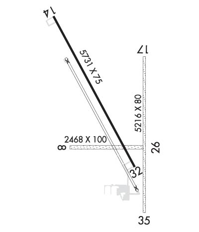
| Lat: N 4020.1 Long: W 10348.3 Elev: 4595 Var: -08 Longest Runway: 5731 | ||
| AWOS: 132.95 CTAF: 123.05 | ||
| ||||||||||||||||||||||||||||||||||||||||||||
| ||||||||||||||||||||||||||||||||||||||||||||
| ||||||||||||||||||||||||||||||||||||||||||||
| Rwy | Rwy | |||||||
| 2468x100 | 2468' | 2468x100 | 2468' | |||||
| 5731x75 | 5731' | 5731x75 | 5731' | |||||
| 5216x80 | 5216' | 5216x80 | 5216' | |||||
| Runway ID | Single Wheel | Double Wheel | Double Tandem Wheel | Dual Double Wheel |
| 08/26 | N/A | N/A | N/A | N/A |
| 14/32 | 30,000 | N/A | N/A | N/A |
| 17/35 | N/A | N/A | N/A | N/A |
| These numbers are Advisory and are not limits. The Airport Manager should have more accurate Weight Limits | ||||
 Airport Diagram might not be current. | |
| Facility Name: | FORT MORGAN MUNI |
| City Name: | FORT MORGAN |
| County: | MORGAN |
| State abbrev: | CO |
| State Name: | COLORADO |
| Ownership: | PUBLICLY OWNED |
| Use: | OPEN TO THE PUBLIC |
| Owner's Name: | CITY OF FORT MORGAN |
| Address: | BOX 100 CITY HALL |
| FORT MORGAN, CO 80701 | |
| Owner's Phone: | 970-867-8414 |
| Manager's Name: | KYLE SCOTT |
| Address: | 23101 HWY 52 |
| FORT MORGAN, CO 80701 | |
| Phone: | 970-867-8414 |
| FAA Region: | NORTHWEST MOUNTAIN |
| FAA Field Office: | DEN |

| Date | Sunrise | Sunset |
|---|---|---|
| 04/25/24 Thursday | 6:01 | 19:45 |
| 04/26/24 Friday | 6:00 | 19:46 |
| 04/27/24 Saturday | 5:59 | 19:47 |
| 04/28/24 Sunday | 5:57 | 19:48 |
| 04/29/24 Monday | 5:56 | 19:49 |
| 04/30/24 Tuesday | 5:55 | 19:50 |
| 05/01/24 Wednesday | 5:54 | 19:51 |
| 05/02/24 Thursday | 5:52 | 19:52 |
| 05/03/24 Friday | 5:51 | 19:53 |
| 05/04/24 Saturday | 5:50 | 19:55 |
| 05/05/24 Sunday | 5:49 | 19:56 |
| 05/06/24 Monday | 5:48 | 19:57 |
| 05/07/24 Tuesday | 5:46 | 19:58 |
| 05/08/24 Wednesday | 5:45 | 19:59 |
| Airport Attendance Schedule | MON-SAT 0800-1700 |
| Airport Status | OPERATIONAL (This Status can change at any time - please check NOTAMS) |
| Airport Lighting Schedule | ACTVT REIL RWY 14 & 32; MIRL RWY 14/32 - CTAF. |
| Airport Storage Available | Tie Downs, Hanger |
| Extra Services Available | Crop Dusting, Air Ambulance, Charter, Flight Instruction, Parachute Jumping |
| Wind Indicator | YES - (lighted) |
| Control Tower | NO |
| CTAF Frequency | 123.050 |
| Unicom Frequency | 123.050 |
| Rotating Beacon Color | WG |
| Segmented Circle | YES |
| Landing Fee | NO |
| Airport Inspected | STATE - performed by STATE AERONAUTICAL PERSONNEL |
| Inspection Date | 06/15/2023 |
| Type of Fuel Available | Grade 100LL, JET A-1 (freeze point -50C); -10FUEL AVAILABLE 24/7 WITH CREDIT CARD. |
| Airframe Repair Service | NONE |
| Power Plant Repair Service | NONE |
| Latitude | N4020.1 |
| Longitude | W10348.3 (ESTIMATED) |
| Arpt Elevation | 4595ft (SURVEYED) |
| Magnetic Variation | 08E |
| 5 miles N | of FORT MORGAN |
| Traffic Pattern Altitude | 1031 |
| Sectional Chart | CHEYENNE |
| Operations (Reported) | Yearly | Avg. Daily |
|---|---|---|
| General Aviation Transient | 4000 | 11 |
| General Aviation Local | 5000 | 14 |
| Air Taxi | 800 | 2 |
| Commerical | 0 | 0 |
| Commuter | 0 | 0 |
| Military | 200 | 1 |
| Aircraft based on Field | |
|---|---|
| General Aviation Singles | 32 |
| General Aviation Multi | 1 |
| Jet Aircraft | 0 |
| General Aviation Helicopters | 2 |
| Military Aircraft | 0 |
| Gliders | 0 |
| Ultralights | 0 |
| FSS on field | NO |
| FSS tie-in | DENVER |
| FSS Phone | 1-800-WX-BRIEF |
| Who issues Notams | DEN |
| Notam D service at airport | YES |
| ARTCC Name | DENVER |
| Airport Certification | |
| Aircraft Rescue & Firefighting Index | None |
| Airport of Entry | No |
| Custom Landing Rights | No |
| Joint Civil/Military | No |
| Military Landing rights | No |
| NATIONAL PLAN OF INTEGRATED AIRPORT SYSTEMS (NPIAS) |
| GRANT AGREEMENTS UNDER FAAP/ADAP/AIP |
| ASSURANCES PURSUANT TO TITLE VI, CIVIL RIGHTS ACT OF 1964 |
| RWY 17/35, 21 ROAD 100 FT E OF AND PARALLEL TO RWY CNTRLN FULL LENGTH. |
| BE ALERT, INTENSIVE USAF STUDENT TRNG INVOF COLORADO SPRINGS & PUEBLO COLORADO. |
| FOR CD CTC DENVER ARTCC AT 303-651-4257. |
Airport Communications & Frequencies:
| |||||||||
| Runway: 08 | Runway: 26 | ||
| Mag heading: | 82° | Mag heading: | 262° |
| Rwy Slope: | -.12% Down | Rwy Slope: | .12% Up |
| Approach: | Approach: | ||
| Pattern: | Left Traffic | Pattern: | Left Traffic |
| Markings: | Markings: | ||
| Marking Condition: | Marking Condition: | ||
| Arresting Dev: | Arresting Dev: | ||
| Lat & Long: | N4020.0 W10348.6 | Lat. & Long.: | N4020.0 W10348.1 |
| Elev: | 4512.2 ft. MSL | Elev: | 4509.3 ft. MSL |
| TCH: | TCH: | ||
| Visual Glide Path: | Visual Glide Path: | ||
| Displaced Threshold: | No | Displaced Threshold: | No |
| Touchdown Zone: | YES | Touchdown Zone: | YES |
| Touchdown Elev.: | 4512.9 feet | Touchdown Elev.: | 4512.9 feet |
| Visual Glide Slope: | Visual Glide Slope: | ||
| RVR Equipment: | RVR Equipment: | ||
| RVV Equipment: | NO | RVV Equipment: | NO |
| Approach Lights: | Approach Lights: | ||
| REIL: | NO | REIL: | NO |
| Centerline Lights: | NO | Centerline Lights: | NO |
| Touchdown lights: | NO | Touchdown lights: | NO |
| Runway Category: | Runway with a Visual Approach | Runway Category: | Runway with a Visual Approach |
| Declared Distances: | Declared Distances: | ||
| Obstructions: | OTHER; INTERMITTENTLY HAS 5 FT HAY BALES 10 FT FROM AND PARALLEL TO THRESHOLD. | Obstructions: | ROAD |
| Marked: | NOT Marked/Lighted | Marked: | NOT Marked/Lighted |
| Clearance slope: | Clearance slope: | 8:1 | |
| Obstruction height: | 10 feet AGL | Obstruction height: | 18 feet AGL |
| Dist. from runway: | 10 feet | Dist. from runway: | 151 feet |
| Centerline offset: | Centerline offset: | ||
| Comments: | Comments: |
| Runway: 14 | Runway: 32 | ||
| Mag heading: | 143° | Mag heading: | 323° |
| Rwy Slope: | -1.50% Down | Rwy Slope: | 1.50% Up |
| Approach: | Approach: | ||
| Pattern: | Left Traffic | Pattern: | Left Traffic |
| Markings: | NONPRECISION INSTRUMENT | Markings: | NONPRECISION INSTRUMENT |
| Marking Condition: | GOOD | Marking Condition: | GOOD |
| Arresting Dev: | Arresting Dev: | ||
| Lat & Long: | N4020.7 W10348.7 | Lat. & Long.: | N4019.9 W10348.1 |
| Elev: | 4595.3 ft. MSL | Elev: | 4509.3 ft. MSL |
| TCH: | 28 ft. AGL | TCH: | 27 ft. AGL |
| Visual Glide Path: | 3.00 degrees | Visual Glide Path: | 3.00 degrees |
| Displaced Threshold: | No | Displaced Threshold: | No |
| Touchdown Zone: | YES | Touchdown Zone: | YES |
| Touchdown Elev.: | 4595.3 feet | Touchdown Elev.: | 4545.8 feet |
| Visual Glide Slope: | 2-Light PAPI on LEFT side of Runway | Visual Glide Slope: | 2-Light PAPI on LEFT side of Runway |
| RVR Equipment: | RVR Equipment: | ||
| RVV Equipment: | NO | RVV Equipment: | NO |
| Approach Lights: | Approach Lights: | ||
| REIL: | YES | REIL: | YES |
| Centerline Lights: | NO | Centerline Lights: | NO |
| Touchdown lights: | NO | Touchdown lights: | NO |
| Runway Category: | Runway with a Non-precision Approach having visibility minimums greater than 3/4 mile | Runway Category: | Runway with a Non-precision Approach having visibility minimums greater than 3/4 mile |
| Declared Distances: | Declared Distances: | ||
| Obstructions: | Obstructions: | ROAD | |
| Marked: | Marked: | NOT Marked/Lighted | |
| Clearance slope: | 50:1 | Clearance slope: | 11:1 |
| Obstruction height: | Obstruction height: | 17 feet AGL | |
| Dist. from runway: | Dist. from runway: | 393 feet | |
| Centerline offset: | Centerline offset: | 298 feet right of centerline | |
| Comments: | Comments: |
| Runway: 17 | Runway: 35 | ||
| Mag heading: | 172° | Mag heading: | 352° |
| Rwy Slope: | -.55% Down | Rwy Slope: | .55% Up |
| Approach: | Approach: | ||
| Pattern: | Left Traffic | Pattern: | Left Traffic |
| Markings: | Markings: | ||
| Marking Condition: | Marking Condition: | ||
| Arresting Dev: | Arresting Dev: | ||
| Lat & Long: | N4020.5 W10348.0 | Lat. & Long.: | N4019.6 W10348.0 |
| Elev: | 4530.7 ft. MSL | Elev: | 4501.8 ft. MSL |
| TCH: | TCH: | ||
| Visual Glide Path: | Visual Glide Path: | ||
| Displaced Threshold: | No | Displaced Threshold: | No |
| Touchdown Zone: | YES | Touchdown Zone: | YES |
| Touchdown Elev.: | 4530.8 feet | Touchdown Elev.: | 4509.0 feet |
| Visual Glide Slope: | Visual Glide Slope: | ||
| RVR Equipment: | RVR Equipment: | ||
| RVV Equipment: | NO | RVV Equipment: | NO |
| Approach Lights: | Approach Lights: | ||
| REIL: | NO | REIL: | NO |
| Centerline Lights: | NO | Centerline Lights: | NO |
| Touchdown lights: | NO | Touchdown lights: | NO |
| Runway Category: | Runway with a Visual Approach | Runway Category: | Runway with a Visual Approach |
| Declared Distances: | Declared Distances: | ||
| Obstructions: | Obstructions: | ROAD | |
| Marked: | Marked: | NOT Marked/Lighted | |
| Clearance slope: | 50:1 | Clearance slope: | |
| Obstruction height: | Obstruction height: | 10 feet AGL | |
| Dist. from runway: | Dist. from runway: | 9 feet | |
| Centerline offset: | Centerline offset: | ||
| Comments: | Comments: |
Thanks for using FltPlan.com
all rights reserved © 1999-2024 by Flight Plan LLC