
| SIERRA VISTA MUNI-LIBBY AAF FORT HUACHUCA SIERRA AZ |
| |
| Lat: N 3135.3 Long: W 11020.7 Elev: 4719 Var: -10 Longest Runway: 12001 | ||
| Dept. ATIS: 134.75 Arr. ATIS: 134.75 AWOS: 119.67 Ground: 121.7 Tower: 124.95 | ||
| ||||||||||||||||||||||||||||||||||||||||||||
| ||||||||||||||||||||||||||||||||||||||||||||
| ||||||||||||||||||||||||||||||||||||||||||||
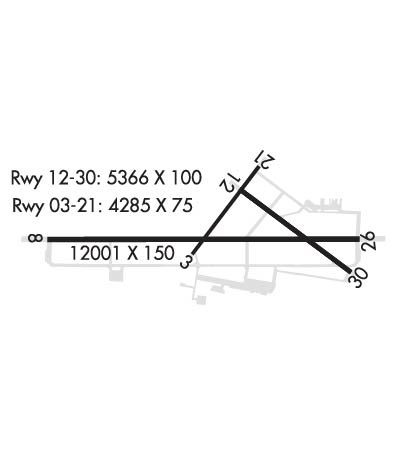
| Rwy | Rwy | |||||||
| 4285x75 | 3032' | 4285x75 | 4285' | |||||
| 12001x150 | 12001' | 12001x150 | 12001' | 109.90 - 259° | ||||
| 5366x100 | 5366' | 5366x100 | 5366' | |||||
| Runway ID | Single Wheel | Double Wheel | Double Tandem Wheel | Dual Double Wheel |
| 03/21 | N/A | N/A | N/A | N/A |
| 08/26 | 75,000 | 200,000 | 450,000 | 700,000 |
| 12/30 | 46,000 | 106,000 | 137,000 | 172,000 |
| H1 | N/A | N/A | N/A | N/A |
| These numbers are Advisory and are not limits. The Airport Manager should have more accurate Weight Limits | ||||
 Airport Diagram might not be current. | |
| Facility Name: | SIERRA VISTA MUNI-LIBBY AAF; FORT HUACHUCA |
| City Name: | FORT HUACHUCA SIERRA VISTA |
| County: | COCHISE |
| State abbrev: | AZ |
| State Name: | ARIZONA |
| Ownership: | ARMY OWNED |
| Use: | OPEN TO THE PUBLIC |
| Owner's Name: | US ARMY INTELLIGENCE CTR; APRON, TRML & NE END OWNED BY CITY OF SIERRA VISTA. |
| Address: | FORT HUACHUCA |
| FORT HUACHUCA, AZ 85613 | |
| Owner's Phone: | 520-538-2860 |
| Manager's Name: | SHARON FLISSAR; MIL AMGR CAROL THOMPSON = 520-538-2861 |
| Address: | 401 GIULIO CESARE AVE |
| SIERRA VISTA, AZ 85635 | |
| Phone: | 520-458-5775 |
| FAA Region: | WESTERN-PACIFIC |
| FAA Field Office: | PHX |
| Date | Sunrise | Sunset |
|---|---|---|
| 04/25/24 Thursday | 5:41 | 18:58 |
| 04/26/24 Friday | 5:40 | 18:58 |
| 04/27/24 Saturday | 5:39 | 18:59 |
| 04/28/24 Sunday | 5:38 | 19:00 |
| 04/29/24 Monday | 5:37 | 19:00 |
| 04/30/24 Tuesday | 5:36 | 19:01 |
| 05/01/24 Wednesday | 5:35 | 19:02 |
| 05/02/24 Thursday | 5:34 | 19:03 |
| 05/03/24 Friday | 5:34 | 19:03 |
| 05/04/24 Saturday | 5:33 | 19:04 |
| 05/05/24 Sunday | 5:32 | 19:05 |
| 05/06/24 Monday | 5:31 | 19:05 |
| 05/07/24 Tuesday | 5:30 | 19:06 |
| 05/08/24 Wednesday | 5:29 | 19:07 |
| Airport Attendance Schedule | MON-FRI 1400-2230Z |
| Airport Status | OPERATIONAL (This Status can change at any time - please check NOTAMS) |
| Airport Lighting Schedule | ACTVT PAPI RWY 08, 26, 12 & 30; HIRL RWY 08/26; MIRL RWY 03/21 & 12/30; PERIMETER LGT H1 - CTAF. |
| Airport Storage Available | Tie Downs |
| Extra Services Available | NONE |
| Wind Indicator | YES - (lighted) |
| Control Tower | YES |
| CTAF Frequency | 124.950; WHEN ATCT CLSD 121.5 MNTD FOR EMERG. |
| Unicom Frequency | 122.950 |
| Rotating Beacon Color | WG |
| Segmented Circle | NO |
| Landing Fee | NO |
| Airport Inspected | FEDERAL - performed by FAA AIRPORTS FIELD PERSONNEL |
| Inspection Date | 02/25/2014 |
| Type of Fuel Available | Grade 100, JET A (freeze point -40C); -A WO ICING INHIBITOR. |
| Airframe Repair Service | None |
| Power Plant Repair Service | None |
| Latitude | N3135.3 |
| Longitude | W11020.7 (ESTIMATED) |
| Arpt Elevation | 4719ft (SURVEYED) |
| Magnetic Variation | 10E |
| 3 miles N | of FORT HUACHUCA SIERRA VISTA |
| Traffic Pattern Altitude | |
| Sectional Chart | PHOENIX |
| Operations (Reported) | Yearly | Avg. Daily |
|---|---|---|
| General Aviation Transient | 10905 | 30 |
| General Aviation Local | 6887 | 19 |
| Air Taxi | 0 | 0 |
| Commerical | 5013 | 14 |
| Commuter | 0 | 0 |
| Military | 96469 | 264 |
| Aircraft based on Field | |
|---|---|
| General Aviation Singles | 35 |
| General Aviation Multi | 3 |
| Jet Aircraft | 0 |
| General Aviation Helicopters | 1 |
| Military Aircraft | 0 |
| Gliders | 1 |
| Ultralights | 0 |
| FSS on field | NO |
| FSS tie-in | PRESCOTT |
| FSS Phone | 1-800-WX-BRIEF |
| Who issues Notams | FHU |
| Notam D service at airport | YES |
| ARTCC Name | ALBUQUERQUE |
| Airport Certification | |
| Aircraft Rescue & Firefighting Index | None |
| Airport of Entry | No |
| Custom Landing Rights | No |
| Joint Civil/Military | YES |
| Military Landing rights | No |
| NATIONAL PLAN OF INTEGRATED AIRPORT SYSTEMS (NPIAS) |
| GRANT AGREEMENTS UNDER FAAP/ADAP/AIP |
| CONVEYANCE UNDER SCETION 16, FEDERAL AIRPORT ACT OF 1946 OR SECTION 23, AIRPORT AND AIRWAY DEVELOPMENT ACT OF 1970 |
| ASSURANCES PURSUANT TO TITLE VI, CIVIL RIGHTS ACT OF 1964 |
| THIS AIRPORT HAS BEEN SURVEYED BY THE NATIONAL GEODETIC SURVEY. |
| WHEN CLASS D ASP IN EFCT UNMANNED AERIAL VEHICLES OPR SFC - 7000 FT MSL. |
| USAF WX FCST AVBL 0500-2000 FM DAVIS MONTHAN AFB. |
| TWY G & J LMTD TO SW ACFT MAX 33000 LB; TWY K LMTD TO SW ACFT MAX 50000 LB; TWY D & ACFT APRON ON NW SIDE LMTD TO DW ACFT MAX 100000 LB. |
| CRCG S OF RWY 08 & 30 NA. |
| MIL JET OPS WKDAYS; BIRD HAZ INVOF RWYS ON TKOF & APCH; DEER ON & INVOF ARPT SPCLY AT NIGHT. |
| FUEL: F24 (JET AA); MIL POL 1330-0100Z MON-FRI; EXC HOL; OTR TIMES 24 HR PRIOR NOTICE - D879-2860/2862. POL SVC RQR CREW ATND TO SPECIFY FUEL/OIL RQMNTS; FUEL LMTD TO 6000 GAL; JET A AVBL 1400-2230Z DLY; OTR TIMES C520-234-3552; SVC FEE. |
| TRAN ALERT: TSNT CTC LIBBY ATC OR BAOPS TO COORD PRKG. |
| CSTMS/AG/IMG: AVBL WITH 72 HR PN FOR US MIL OR DOD CONTR ACFT ONLY. |
| MISC: TSNT & RON ACFT USING MIL SIDE SIGN IN AT BAOPS PRIOR TO DEPG FLT LINE. ASSAULT STRIP 5 NM NE 72 HR PPR. NONSKED ARR RQRG ASST - EOC 533-2291. |
| PRKG MIL TSNT SIGN IN AT BASE OPS PRIOR TO LV FLT LINE. |
| MILITARY USE: OPR 0600-0600Z SUN-SAT; EXC HOL. OTR TIME 72 HR PPR - D879-2860/2862/C520-538-2860/2862. SEE FLIP AP/1 SUPPLEMENTARY ARPT |
| RADAR: SEE TERM FLIP FOR RADAR MINIMA. |
| MISC: WX OBSN/FCST 0600-0600Z SUN-FRI; EXC HOL. OTR TIMES ASOS. LIBBY WX AVBL - 122.95 D879-3798/2865/C520-538-3798/2865. |
| RSTD: 24 HR PPR FOR TSNT MIL; CIV ACFT PPR TO ENTER MIL RAMP. |
| CTN: EXP WS ALL RWYS; ARPT SW WIND MAY NOT REP WIND ON FNA. |
| MISC: REMOTE BRIEFING SVC AVBL 25 OWS DAVIS-MONTHAN AFB D228-6598/6599/6588/C520-228-6598/6599/6588 OR HTTPS://25OWS.US.AF.MIL. |
| MISC: LIBBY BAOPS 0600-0600Z SUN-SAT; EXC HOL. TR TIME 72 HR PPR. D879-2860/2862/C520-538-2860/2862. |
| RSTD: TWY G LMTD TO S33; TWY K LMTD TO S50. |
| ASP CLASS D SFC AREA LMTD TO DEP & FSL DURG NGT UNMANNED ACFT OPS; EXP DELAYS. MANNED & UNMANNED ACFT NOT AUTH IN SAME TFC PAT. MANNED ARR MAY FLW UNMANNED ACFT ON FNA. |
| CIVIL TFC PAT UNAVBL DURG DALGT UNMANNED ACFT TFC PAT OPS; DEP & FSL AUTH. |
| TPA: 981 FT AGL FIXED WING UNMANNED ACFT. |
| TPA: DO NOT EXCEED 5700 FT UNTIL DER. |
| CTN: RWY 08/26 & 12/30 OVRNS UNAVBL; BLW 25 PAVEMENT COND INDEX. |
| TWY P & S EDGE LGT N/A. |
| TFC PAT: FIXED WING NORTH; ROTARY WING SOUTH; ALT FIXED WING RECIPROCATING 5700 FT; ROTOR WING 5500 FT; FIXED WING TURBOPROP/JET 6200 FT. |
Airport Communications & Frequencies:
| |||||||||||||||||||||||||||||||||
| Runway: 03 | Runway: 21 | ||
| Mag heading: | 27° | Mag heading: | 207° |
| Rwy Slope: | -1.99% Down | Rwy Slope: | 1.99% Up |
| Approach: | Approach: | ||
| Pattern: | Left Traffic | Pattern: | Right Traffic |
| Markings: | NONPRECISION INSTRUMENT | Markings: | NONPRECISION INSTRUMENT |
| Marking Condition: | GOOD | Marking Condition: | GOOD |
| Arresting Dev: | Arresting Dev: | ||
| Lat & Long: | N3135.2 W11020.9 | Lat. & Long.: | N3135.7 W11020.4 |
| Elev: | 4670.5 ft. MSL | Elev: | 4585.2 ft. MSL |
| TCH: | TCH: | ||
| Visual Glide Path: | Visual Glide Path: | ||
| Displaced Threshold: | 1253 feet | Displaced Threshold: | No |
| Touchdown Zone: | YES | Touchdown Zone: | YES |
| Touchdown Elev.: | 4648.0 feet | Touchdown Elev.: | 4647.4 feet |
| Visual Glide Slope: | Visual Glide Slope: | ||
| RVR Equipment: | RVR Equipment: | ||
| RVV Equipment: | NO | RVV Equipment: | NO |
| Approach Lights: | Approach Lights: | ||
| REIL: | NO | REIL: | NO |
| Centerline Lights: | NO | Centerline Lights: | NO |
| Touchdown lights: | NO | Touchdown lights: | NO |
| Runway Category: | Runway with a Visual Approach | Runway Category: | Runway with a Visual Approach |
| Declared Distances: | TORA:4285' TODA:4285' ASDA:4285' LDA:3032' | Declared Distances: | TORA:4285' TODA:4285' ASDA:4285' LDA:4285' |
| Runway: 08 | Runway: 26 | ||
| Mag heading: | 80° | Mag heading: | 260° |
| Rwy Slope: | -1.00% Down | Rwy Slope: | 1.00% Up |
| Approach: | Approach: | LOC/GS | |
| Pattern: | Left Traffic | Pattern: | Right Traffic |
| Markings: | PRECISION INSTRUMENT | Markings: | PRECISION INSTRUMENT |
| Marking Condition: | GOOD | Marking Condition: | GOOD |
| Arresting Dev: | Arresting Dev: | ||
| Lat & Long: | N3135.3 W11022.0 | Lat. & Long.: | N3135.3 W11019.7 |
| Elev: | 4719.1 ft. MSL | Elev: | 4599.0 ft. MSL |
| TCH: | 50 ft. AGL | TCH: | 80 ft. AGL |
| Visual Glide Path: | 3.00 degrees | Visual Glide Path: | 3.00 degrees |
| Displaced Threshold: | No | Displaced Threshold: | No |
| Touchdown Zone: | YES | Touchdown Zone: | YES |
| Touchdown Elev.: | 4719.1 feet | Touchdown Elev.: | 4629.0 feet |
| Visual Glide Slope: | 4-Light PAPI on LEFT side of Runway | Visual Glide Slope: | 4-Light PAPI on LEFT side of Runway |
| RVR Equipment: | RVR Equipment: | ||
| RVV Equipment: | NO | RVV Equipment: | NO |
| Approach Lights: | Approach Lights: | ||
| REIL: | NO | REIL: | NO |
| Centerline Lights: | NO | Centerline Lights: | NO |
| Touchdown lights: | NO | Touchdown lights: | NO |
| Runway Category: | Runway with a Non-precision Approach having visibility minimums greater than 3/4 mile | Runway Category: | Precision Instrument Runway |
| Declared Distances: | TORA:12001' TODA:12001' ASDA:12001' LDA:12001' | Declared Distances: | TORA:12001' TODA:12001' ASDA:12001' LDA:12001' |
| Runway: 12 | Runway: 30 | ||
| Mag heading: | 117° | Mag heading: | 297° |
| Rwy Slope: | .06% Up | Rwy Slope: | -.06% Down |
| Approach: | Approach: | ||
| Pattern: | Left Traffic | Pattern: | Right Traffic |
| Markings: | NONPRECISION INSTRUMENT | Markings: | NONPRECISION INSTRUMENT |
| Marking Condition: | GOOD | Marking Condition: | GOOD |
| Arresting Dev: | Arresting Dev: | ||
| Lat & Long: | N3135.6 W11020.6 | Lat. & Long.: | N3135.0 W11019.8 |
| Elev: | 4611.6 ft. MSL | Elev: | 4614.8 ft. MSL |
| TCH: | 51 ft. AGL | TCH: | 51 ft. AGL |
| Visual Glide Path: | 3.00 degrees | Visual Glide Path: | 3.00 degrees |
| Displaced Threshold: | No | Displaced Threshold: | No |
| Touchdown Zone: | YES | Touchdown Zone: | YES |
| Touchdown Elev.: | 4618.6 feet | Touchdown Elev.: | 4619.6 feet |
| Visual Glide Slope: | 4-Light PAPI on LEFT side of Runway | Visual Glide Slope: | 4-Light PAPI on RIGHT side of Runway |
| RVR Equipment: | RVR Equipment: | ||
| RVV Equipment: | NO | RVV Equipment: | NO |
| Approach Lights: | Approach Lights: | ||
| REIL: | NO | REIL: | NO |
| Centerline Lights: | NO | Centerline Lights: | NO |
| Touchdown lights: | NO | Touchdown lights: | NO |
| Runway Category: | Runway with a Visual Approach | Runway Category: | Runway with a Visual Approach |
| Declared Distances: | TORA:5366' TODA:5366' ASDA:5366' LDA:5366' | Declared Distances: | TORA:5366' TODA:5366' ASDA:5366' LDA:5366' |
Thanks for using FltPlan.com
all rights reserved © 1999-2024 by Flight Plan LLC