
| ALBERTUS FREEPORT IL |
| |
| Lat: N 4214.8 Long: W 08934.9 Elev: 859 Var: -00 Longest Runway: 5504 | ||
| Clr Del: 121.85 AWOS: 120.52 CTAF: 122.8 | ||
| ||||||||||||||||||||||||||||||||||||||||||||
| ||||||||||||||||||||||||||||||||||||||||||||
| ||||||||||||||||||||||||||||||||||||||||||||
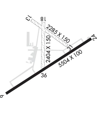
| Rwy | Rwy | |||||||
| 5504x100 | 5504' | 5504x100 | 5504' | 108.30 - 234° | ||||
| 2285x150 | 2285' | 2285x150 | 2285' | |||||
| 2404x150 | 2404' | 2404x150 | 2404' | |||||
| Runway ID | Single Wheel | Double Wheel | Double Tandem Wheel | Dual Double Wheel |
| 06/24 | 20,000 | 60,000 | N/A | N/A |
| 13/31 | N/A | N/A | N/A | N/A |
| 18/36 | N/A | N/A | N/A | N/A |
| These numbers are Advisory and are not limits. The Airport Manager should have more accurate Weight Limits | ||||
 Airport Diagram might not be current. | |
| Facility Name: | ALBERTUS |
| City Name: | FREEPORT |
| County: | STEPHENSON |
| State abbrev: | IL |
| State Name: | ILLINOIS |
| Ownership: | PUBLICLY OWNED |
| Use: | OPEN TO THE PUBLIC |
| Owner's Name: | CITY OF FREEPORT |
| Address: | CITY HALL , 314 W. STEPHENSON, 324 W. STEPHENSON |
| FREEPORT, IL 61032 | |
| Owner's Phone: | 815-235-8200 |
| Manager's Name: | ANGIE JANNSEN |
| Address: | 1255 E AIRPORT ROAD |
| FREEPORT, IL 61032 | |
| Phone: | 815-232-1078 |
| FAA Region: | GREAT LAKES |
| FAA Field Office: | CHI |

| Date | Sunrise | Sunset |
|---|---|---|
| 04/25/24 Thursday | 6:01 | 19:52 |
| 04/26/24 Friday | 6:00 | 19:53 |
| 04/27/24 Saturday | 5:58 | 19:54 |
| 04/28/24 Sunday | 5:57 | 19:55 |
| 04/29/24 Monday | 5:55 | 19:56 |
| 04/30/24 Tuesday | 5:54 | 19:57 |
| 05/01/24 Wednesday | 5:53 | 19:59 |
| 05/02/24 Thursday | 5:51 | 20:00 |
| 05/03/24 Friday | 5:50 | 20:01 |
| 05/04/24 Saturday | 5:49 | 20:02 |
| 05/05/24 Sunday | 5:48 | 20:03 |
| 05/06/24 Monday | 5:46 | 20:04 |
| 05/07/24 Tuesday | 5:45 | 20:05 |
| 05/08/24 Wednesday | 5:44 | 20:06 |
| Airport Attendance Schedule | MON-FRI 0800-1700, SAT 0900-1600 |
| Airport Status | OPERATIONAL (This Status can change at any time - please check NOTAMS) |
| Airport Lighting Schedule | MIRL RY 06/24 & TWY LGTS PRESET ON LOW INTST SS-SR; TO INCR INTST & ACTVT MALSR RY 24 - CTAF. PAPI RYS 06 & 24 OPERATE CONTINUOUSLY. |
| Airport Storage Available | Tie Downs, Hanger |
| Extra Services Available | Flight Instruction, Aircraft Rental |
| Wind Indicator | YES - (lighted) |
| Control Tower | NO |
| CTAF Frequency | 122.800 |
| Unicom Frequency | 122.800 |
| Rotating Beacon Color | WG |
| Segmented Circle | YES |
| Landing Fee | NO |
| Airport Inspected | STATE - performed by STATE AERONAUTICAL PERSONNEL |
| Inspection Date | 07/14/2023 |
| Type of Fuel Available | Grade 100LL, JET A (freeze point -40C); -10100 LL AVAILABLE 24HR SELF SERVICE |
| Airframe Repair Service | MAJOR |
| Power Plant Repair Service | MAJOR |
| Latitude | N4214.8 |
| Longitude | W08934.9 (ESTIMATED) |
| Arpt Elevation | 859ft (SURVEYED) |
| Magnetic Variation | 00E |
| 3 miles SE | of FREEPORT |
| Traffic Pattern Altitude | 400; TPA: 400 FT AGL ULTRALIGHTS, 800 FT AGL PISTON ACFT. |
| Sectional Chart | CHICAGO |
| Operations (Reported) | Yearly | Avg. Daily |
|---|---|---|
| General Aviation Transient | 8000 | 22 |
| General Aviation Local | 12000 | 33 |
| Air Taxi | 0 | 0 |
| Commerical | 0 | 0 |
| Commuter | 0 | 0 |
| Military | 0 | 0 |
| Aircraft based on Field | |
|---|---|
| General Aviation Singles | 35 |
| General Aviation Multi | 2 |
| Jet Aircraft | 0 |
| General Aviation Helicopters | 0 |
| Military Aircraft | 0 |
| Gliders | 10 |
| Ultralights | 0 |
| FSS on field | NO |
| FSS tie-in | KANKAKEE |
| FSS Phone | 1-800-WX-BRIEF |
| Who issues Notams | FEP |
| Notam D service at airport | YES |
| ARTCC Name | CHICAGO |
| Airport Certification | |
| Aircraft Rescue & Firefighting Index | None |
| Airport of Entry | No |
| Custom Landing Rights | No |
| Joint Civil/Military | No |
| Military Landing rights | YES |
| NATIONAL PLAN OF INTEGRATED AIRPORT SYSTEMS (NPIAS) |
| GRANT AGREEMENTS UNDER FAAP/ADAP/AIP |
| ASSURANCES PURSUANT TO TITLE VI, CIVIL RIGHTS ACT OF 1964 |
| FOR CD CTC CHICAGO ARTCC AT 630-906-8921. |
Airport Communications & Frequencies:
| ||||||||||||||||
| Runway: 06 | Runway: 24 | ||
| Mag heading: | 54° | Mag heading: | 234° |
| Rwy Slope: | -.33% Down | Rwy Slope: | .33% Up |
| Approach: | Approach: | ILS/DME | |
| Pattern: | Left Traffic | Pattern: | Left Traffic |
| Markings: | NONPRECISION INSTRUMENT | Markings: | PRECISION INSTRUMENT |
| Marking Condition: | GOOD | Marking Condition: | GOOD |
| Arresting Dev: | Arresting Dev: | ||
| Lat & Long: | N4214.4 W08935.4 | Lat. & Long.: | N4214.9 W08934.4 |
| Elev: | 859.0 ft. MSL | Elev: | 840.6 ft. MSL |
| TCH: | 50 ft. AGL | TCH: | 46 ft. AGL |
| Visual Glide Path: | 3.00 degrees | Visual Glide Path: | 3.00 degrees |
| Displaced Threshold: | No | Displaced Threshold: | No |
| Touchdown Zone: | YES | Touchdown Zone: | YES |
| Touchdown Elev.: | 859.0 feet | Touchdown Elev.: | 847.0 feet |
| Visual Glide Slope: | 4-Light PAPI on LEFT side of Runway | Visual Glide Slope: | 4-Light PAPI on LEFT side of Runway |
| RVR Equipment: | RVR Equipment: | ||
| RVV Equipment: | NO | RVV Equipment: | NO |
| Approach Lights: | Approach Lights: | MALSR - 1,400 foot medium intensity approach lighting system with runway alignment indicator lights | |
| REIL: | NO | REIL: | NO |
| Centerline Lights: | NO | Centerline Lights: | NO |
| Touchdown lights: | NO | Touchdown lights: | NO |
| Runway Category: | D | Runway Category: | Precision Instrument Runway |
| Declared Distances: | Declared Distances: | ||
| Obstructions: | TREE | Obstructions: | |
| Marked: | NOT Marked/Lighted | Marked: | |
| Clearance slope: | 34:1 | Clearance slope: | 50:1 |
| Obstruction height: | 52 feet AGL | Obstruction height: | |
| Dist. from runway: | 2118 feet | Dist. from runway: | |
| Centerline offset: | 243 right of centerline | Centerline offset: | |
| Comments: | Comments: |
| Runway: 13 | Runway: 31 | ||
| Mag heading: | 126° | Mag heading: | 306° |
| Rwy Slope: | .28% Up | Rwy Slope: | -.28% Down |
| Approach: | Approach: | ||
| Pattern: | Left Traffic | Pattern: | Left Traffic |
| Markings: | NONE | Markings: | NONE |
| Marking Condition: | 13/31 THLDS MKD WITH IN-GROUND CONC MARKERS. | Marking Condition: | |
| Arresting Dev: | Arresting Dev: | ||
| Lat & Long: | N4215.0 W08935.1 | Lat. & Long.: | N4214.8 W08934.7 |
| Elev: | 834.7 ft. MSL | Elev: | 841.1 ft. MSL |
| TCH: | TCH: | ||
| Visual Glide Path: | Visual Glide Path: | ||
| Displaced Threshold: | No | Displaced Threshold: | No |
| Touchdown Zone: | NO | Touchdown Zone: | NO |
| Touchdown Elev.: | Touchdown Elev.: | ||
| Visual Glide Slope: | Visual Glide Slope: | ||
| RVR Equipment: | RVR Equipment: | ||
| RVV Equipment: | NO | RVV Equipment: | NO |
| Approach Lights: | Approach Lights: | ||
| REIL: | NO | REIL: | NO |
| Centerline Lights: | NO | Centerline Lights: | NO |
| Touchdown lights: | NO | Touchdown lights: | NO |
| Runway Category: | Runway with a Visual Approach | Runway Category: | Runway with a Visual Approach |
| Declared Distances: | Declared Distances: |
| Runway: 18 | Runway: 36 | ||
| Mag heading: | 179° | Mag heading: | 359° |
| Rwy Slope: | .41% Up | Rwy Slope: | -.41% Down |
| Approach: | Approach: | ||
| Pattern: | Left Traffic | Pattern: | Left Traffic |
| Markings: | NONE | Markings: | NONE |
| Marking Condition: | 18/36 THLDS MKD WITH IN-GROUND CONC MARKERS. | Marking Condition: | |
| Arresting Dev: | Arresting Dev: | ||
| Lat & Long: | N4215.0 W08935.0 | Lat. & Long.: | N4214.7 W08935.0 |
| Elev: | 835.0 ft. MSL | Elev: | 844.9 ft. MSL |
| TCH: | TCH: | ||
| Visual Glide Path: | Visual Glide Path: | ||
| Displaced Threshold: | No | Displaced Threshold: | No |
| Touchdown Zone: | YES | Touchdown Zone: | YES |
| Touchdown Elev.: | 835.0 feet | Touchdown Elev.: | 835.0 feet |
| Visual Glide Slope: | Visual Glide Slope: | ||
| RVR Equipment: | RVR Equipment: | ||
| RVV Equipment: | NO | RVV Equipment: | NO |
| Approach Lights: | Approach Lights: | ||
| REIL: | NO | REIL: | NO |
| Centerline Lights: | NO | Centerline Lights: | NO |
| Touchdown lights: | NO | Touchdown lights: | NO |
| Runway Category: | Runway with a Visual Approach | Runway Category: | Runway with a Visual Approach |
| Declared Distances: | Declared Distances: |
Thanks for using FltPlan.com
all rights reserved © 1999-2024 by Flight Plan LLC