
| FLYING CLOUD MINNEAPOLIS MN |
| |
| Lat: N 4449.7 Long: W 09327.5 Elev: 906 Var: -03 Longest Runway: 5001 | ||
| Clr Del: 121.7 TWR CLD Dept. ATIS: 124.9 Arr. ATIS: 124.9 Ground: 121.7 Tower: 119.15/125.2 | ||
| |||||||||||||||||||||||||||||||||||||||||||||||||||||||||||||||||||||
| |||||||||||||||||||||||||||||||||||||||||||||||||||||||||||||||||||||
| |||||||||||||||||||||||||||||||||||||||||||||||||||||||||||||||||||||
| |||||||||||||||||||||||||||||||||||||||||||||||||||||||||||||||||||||
| |||||||||||||||||||||||||||||||||||||||||||||||||||||||||||||||||||||
| |||||||||||||||||||||||||||||||||||||||||||||||||||||||||||||||||||||
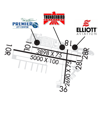
| FBOs at nearby airports who want your business: | |||||||||||
| |||||||||||
| Rwy | Rwy | |||||||
| 3901x75 | 3901' | 3901x75 | 3901' | |||||
| 5001x100 | 5001' | 109.70 - 098° | 5001x100 | 5001' | ||||
| 2690x75 | 2690' | 2690x75 | 2690' | |||||
| Runway ID | Single Wheel | Double Wheel | Double Tandem Wheel | Dual Double Wheel |
| 10L/28R | 12,500 | N/A | N/A | N/A |
| 10R/28L | 30,000 | 60,000 | N/A | N/A |
| 18/36 | 12,500 | N/A | N/A | N/A |
| These numbers are Advisory and are not limits. The Airport Manager should have more accurate Weight Limits | ||||
 Airport Diagram might not be current. | |
| Facility Name: | FLYING CLOUD |
| City Name: | MINNEAPOLIS |
| County: | HENNEPIN |
| State abbrev: | MN |
| State Name: | MINNESOTA |
| Ownership: | PUBLICLY OWNED |
| Use: | OPEN TO THE PUBLIC |
| Owner's Name: | METROPOLITAN AIRPORT CMSN |
| Address: | 6040 28TH AVE S |
| MINNEAPOLIS, MN 55450-2799 | |
| Owner's Phone: | 612-726-8100 |
| Manager's Name: | ROBERT DOCKRY; BLAINE.PETERSON@MSPMAC.ORG. |
| Address: | 9960 FLYING CLOUD DRIVE |
| EDEN PRAIRIE, MN 55347-4016 | |
| Phone: | 952-944-1035; ARPT OFC NR 952-944-1035. |
| FAA Region: | GREAT LAKES |
| FAA Field Office: | DMA |
| Date | Sunrise | Sunset |
|---|---|---|
| 04/25/24 Thursday | 6:11 | 20:13 |
| 04/26/24 Friday | 6:10 | 20:14 |
| 04/27/24 Saturday | 6:08 | 20:15 |
| 04/28/24 Sunday | 6:07 | 20:16 |
| 04/29/24 Monday | 6:05 | 20:18 |
| 04/30/24 Tuesday | 6:04 | 20:19 |
| 05/01/24 Wednesday | 6:02 | 20:20 |
| 05/02/24 Thursday | 6:01 | 20:21 |
| 05/03/24 Friday | 6:00 | 20:22 |
| 05/04/24 Saturday | 5:58 | 20:24 |
| 05/05/24 Sunday | 5:57 | 20:25 |
| 05/06/24 Monday | 5:55 | 20:26 |
| 05/07/24 Tuesday | 5:54 | 20:27 |
| 05/08/24 Wednesday | 5:53 | 20:28 |
| Airport Attendance Schedule | CONTINUOUS |
| Airport Status | OPERATIONAL (This Status can change at any time - please check NOTAMS) |
| Airport Lighting Schedule | WHEN ATCT CLSD ACTVT OR INCR INTST MALSR RWY 10R; REIL RWY 28L, 18, & 36; PAPI RWY 10R, 28L, 18, & 36; HIRL RWY 10R/28L; MIRL RWY 18/36 - CTAF. |
| Airport Storage Available | Tie Downs, Hanger |
| Extra Services Available | Air Ambulance, Avionics, Charter, Flight Instruction, Aircraft Rental, Aircraft Sales |
| Wind Indicator | YES - (lighted) |
| Control Tower | YES |
| CTAF Frequency | 119.150 |
| Unicom Frequency | 122.950 |
| Rotating Beacon Color | WG |
| Segmented Circle | NO |
| Landing Fee | YES |
| Airport Inspected | STATE - performed by STATE AERONAUTICAL PERSONNEL |
| Inspection Date | 10/25/2023 |
| Type of Fuel Available | Grade 100LL, JET A (freeze point -40C); -A JET A LDG FEE, CTC FBO. |
| Airframe Repair Service | MAJOR |
| Power Plant Repair Service | MAJOR |
| Latitude | N4449.7 |
| Longitude | W09327.5 (ESTIMATED) |
| Arpt Elevation | 906ft (SURVEYED) |
| Magnetic Variation | 03E |
| 11 miles SW | of MINNEAPOLIS |
| Traffic Pattern Altitude | |
| Sectional Chart | TWIN CITIES |
| Operations (Reported) | Yearly | Avg. Daily |
|---|---|---|
| General Aviation Transient | 55177 | 151 |
| General Aviation Local | 62717 | 172 |
| Air Taxi | 4266 | 12 |
| Commerical | 6 | 0 |
| Commuter | 0 | 0 |
| Military | 115 | 0 |
| Aircraft based on Field | |
|---|---|
| General Aviation Singles | 241 |
| General Aviation Multi | 25 |
| Jet Aircraft | 26 |
| General Aviation Helicopters | 2 |
| Military Aircraft | 0 |
| Gliders | 0 |
| Ultralights | 0 |
| FSS on field | NO |
| FSS tie-in | PRINCETON |
| FSS Phone | 1-800-WX-BRIEF |
| Who issues Notams | FCM |
| Notam D service at airport | YES |
| ARTCC Name | MINNEAPOLIS |
| Airport Certification | |
| Aircraft Rescue & Firefighting Index | None |
| Airport of Entry | No |
| Custom Landing Rights | No |
| Joint Civil/Military | No |
| Military Landing rights | YES |
| NATIONAL PLAN OF INTEGRATED AIRPORT SYSTEMS (NPIAS) |
| GRANT AGREEMENTS UNDER FAAP/ADAP/AIP |
| ASSURANCES PURSUANT TO TITLE VI, CIVIL RIGHTS ACT OF 1964 |
| DEER, BIRDS & WILDLIFE ON AND INVOF ARPT. |
| RY 10R IS CALM WIND RY WHEN ATCT CLSD. |
| TWY 'A' BTN PREMIER JET RAMP & THUNDERBIRD RAMP CLSD TO ACFT WINGSPANS 56 FT OR GTR. |
| TWY 'D' CLOSED FM TWY 'D2' TO APCH END RY 36 TO ACFT WITH WINGSPANS OF 66 FT OR GREATER. |
| TWY A CLSD EAST OF BARON LANE TO ACFT WITH WINGSPANS 54 FT OR GREATER. |
| RWY INCURSION RISK - PILOTS ARE REMINDED TO REVIEW ARPT HOT SPOT INFO BFR TXG FOR DEP & BFR LDG. SEE TPP ARPT DIAGRAM & CHART SUPPL SXN ON HOT SPOTS FOR ADDN INFO. |
| WRONG RWY ARR RISK, CLOSELY ALIGNED PARL RWYS. SEE TPP ARPT DIAGRAM. |
| TWY D BTWN D1 & D2 CLSD TO ACFT WINGSPANS 48 FT OR GTR. |
| TXL G CLSD TO WINGSPANS GTR THAN 43 FT. |
| TXL H CLSD TO WINGSPANS GTR THAN 40 FT. |
| ARPT CLSD TO: JETS NOT MEETING FAR 36, JET TRNG & ACFT W/ CERTIFICATED MGTOW HIGHER THAN 60,000 LBS. |
| ULTRALIGHT OPNS PROHIBITED. |
| MAINTENANCE RUN-UPS ARE PROHIBITED BTN 2200-0700 LCL. |
| WHEN ATCT CLSD, SNOW REMOVAL OPERATORS MONITOR 119.15. |
| RWY 10L/ 28RCLSD WHEN ATCT CLSD. |
Airport Communications & Frequencies:
| ||||||||||||||||||||||||||||||
| Runway: 10L | Runway: 28R | ||
| Mag heading: | 98° | Mag heading: | 278° |
| Rwy Slope: | -.17% Down | Rwy Slope: | .17% Up |
| Approach: | Approach: | ||
| Pattern: | Left Traffic | Pattern: | Right Traffic |
| Markings: | NONPRECISION INSTRUMENT | Markings: | NONPRECISION INSTRUMENT |
| Marking Condition: | GOOD | Marking Condition: | GOOD |
| Arresting Dev: | Arresting Dev: | ||
| Lat & Long: | N4449.8 W09327.9 | Lat. & Long.: | N4449.7 W09327.0 |
| Elev: | 906.0 ft. MSL | Elev: | 899.5 ft. MSL |
| TCH: | 39 ft. AGL | TCH: | 38 ft. AGL |
| Visual Glide Path: | 3.00 degrees | Visual Glide Path: | 3.00 degrees |
| Displaced Threshold: | No | Displaced Threshold: | No |
| Touchdown Zone: | YES | Touchdown Zone: | YES |
| Touchdown Elev.: | 906.2 feet | Touchdown Elev.: | 903.9 feet |
| Visual Glide Slope: | 4-Light PAPI on LEFT side of Runway | Visual Glide Slope: | 4-Light PAPI on LEFT side of Runway |
| RVR Equipment: | RVR Equipment: | ||
| RVV Equipment: | NO | RVV Equipment: | NO |
| Approach Lights: | Approach Lights: | ||
| REIL: | YES | REIL: | YES |
| Centerline Lights: | NO | Centerline Lights: | NO |
| Touchdown lights: | NO | Touchdown lights: | NO |
| Runway Category: | Runway with a Non-precision Approach | Runway Category: | Runway with a Non-precision Approach |
| Declared Distances: | Declared Distances: |
| Runway: 10R | Runway: 28L | ||
| Mag heading: | 98° | Mag heading: | 278° |
| Rwy Slope: | .04% Up | Rwy Slope: | -.04% Down |
| Approach: | ILS | Approach: | |
| Pattern: | Right Traffic | Pattern: | Left Traffic |
| Markings: | PRECISION INSTRUMENT | Markings: | NONPRECISION INSTRUMENT |
| Marking Condition: | GOOD | Marking Condition: | GOOD |
| Arresting Dev: | Arresting Dev: | ||
| Lat & Long: | N4449.7 W09328.2 | Lat. & Long.: | N4449.6 W09327.1 |
| Elev: | 896.2 ft. MSL | Elev: | 898.3 ft. MSL |
| TCH: | 42 ft. AGL | TCH: | 44 ft. AGL |
| Visual Glide Path: | 3.00 degrees | Visual Glide Path: | 3.00 degrees |
| Displaced Threshold: | No | Displaced Threshold: | No |
| Touchdown Zone: | YES | Touchdown Zone: | YES |
| Touchdown Elev.: | 906.2 feet | Touchdown Elev.: | 905.8 feet |
| Visual Glide Slope: | 4-Light PAPI on LEFT side of Runway | Visual Glide Slope: | 4-Light PAPI on LEFT side of Runway |
| RVR Equipment: | RVR Equipment: | ||
| RVV Equipment: | NO | RVV Equipment: | NO |
| Approach Lights: | MALSR - 1,400 foot medium intensity approach lighting system with runway alignment indicator lights | Approach Lights: | |
| REIL: | NO | REIL: | YES |
| Centerline Lights: | NO | Centerline Lights: | NO |
| Touchdown lights: | NO | Touchdown lights: | NO |
| Runway Category: | Precision Instrument Runway | Runway Category: | Runway with a Non-precision Approach having visibility minimums greater than 3/4 mile |
| Declared Distances: | Declared Distances: | ||
| Obstructions: | TREE | Obstructions: | |
| Marked: | NOT Marked/Lighted | Marked: | |
| Clearance slope: | 47:1 | Clearance slope: | 34:1 |
| Obstruction height: | 61 feet AGL | Obstruction height: | |
| Dist. from runway: | 3085 feet | Dist. from runway: | |
| Centerline offset: | 131 left of centerline | Centerline offset: | |
| Comments: | Comments: |
| Runway: 18 | Runway: 36 | ||
| Mag heading: | 183° | Mag heading: | 3° |
| Rwy Slope: | .22% Up | Rwy Slope: | -.22% Down |
| Approach: | Approach: | ||
| Pattern: | Left Traffic | Pattern: | Left Traffic |
| Markings: | NONPRECISION INSTRUMENT | Markings: | NONPRECISION INSTRUMENT |
| Marking Condition: | GOOD | Marking Condition: | GOOD |
| Arresting Dev: | Arresting Dev: | ||
| Lat & Long: | N4449.7 W09327.3 | Lat. & Long.: | N4449.3 W09327.3 |
| Elev: | 899.1 ft. MSL | Elev: | 905.0 ft. MSL |
| TCH: | 45 ft. AGL | TCH: | 27 ft. AGL |
| Visual Glide Path: | 3.50 degrees | Visual Glide Path: | 3.00 degrees |
| Displaced Threshold: | No | Displaced Threshold: | No |
| Touchdown Zone: | YES | Touchdown Zone: | YES |
| Touchdown Elev.: | 905.1 feet | Touchdown Elev.: | 905.1 feet |
| Visual Glide Slope: | 4-Light PAPI on LEFT side of Runway | Visual Glide Slope: | 4-Light PAPI on LEFT side of Runway; RY 36 PAPI UNUSBL BYD 6 DEG LEFT OF CNTRLN. |
| RVR Equipment: | RVR Equipment: | ||
| RVV Equipment: | NO | RVV Equipment: | NO |
| Approach Lights: | Approach Lights: | ||
| REIL: | YES | REIL: | YES |
| Centerline Lights: | NO | Centerline Lights: | NO |
| Touchdown lights: | NO | Touchdown lights: | NO |
| Runway Category: | Runway with a Visual Approach | Runway Category: | Runway with a Non-precision Approach |
| Declared Distances: | Declared Distances: | ||
| Obstructions: | TANK | Obstructions: | FENCE |
| Marked: | NOT Marked/Lighted | Marked: | NOT Marked/Lighted |
| Clearance slope: | 14:1 | Clearance slope: | 5:1 |
| Obstruction height: | 48 feet AGL | Obstruction height: | 4 feet AGL |
| Dist. from runway: | 907 feet | Dist. from runway: | 219 feet |
| Centerline offset: | 262 right of centerline | Centerline offset: | 151 feet right of centerline |
| Comments: | Comments: | RWY 36 HAS 5 FT FENCE 129 FT FROM THE RWY END AND 244 FT R. |
Thanks for using FltPlan.com
all rights reserved © 1999-2024 by Flight Plan LLC