
| FORT BRIDGER FORT BRIDGER WY |
| |
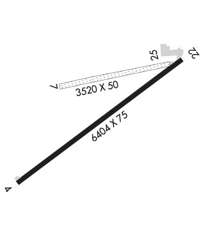
| Lat: N 4123.6 Long: W 11024.4 Elev: 7038 Var: -11 Longest Runway: 6404 | ||
| AWOS: 118.8 CTAF: 122.8 | ||
| ||||||||||||||||||||||||||||||||||||||||||||
| ||||||||||||||||||||||||||||||||||||||||||||
| ||||||||||||||||||||||||||||||||||||||||||||
| Rwy | Rwy | |||||||
| 6404x75 | 6404' | 6404x75 | 6404' | |||||
| 3520x50 | 3520' | 3520x50 | 3520' | |||||
| Runway ID | Single Wheel | Double Wheel | Double Tandem Wheel | Dual Double Wheel |
| 04/22 | 12,500 | 20,000 | 20,000 | N/A |
| 07/25 | N/A | N/A | N/A | N/A |
| These numbers are Advisory and are not limits. The Airport Manager should have more accurate Weight Limits | ||||
 Airport Diagram might not be current. | |
| Facility Name: | FORT BRIDGER |
| City Name: | FORT BRIDGER |
| County: | UINTA |
| State abbrev: | WY |
| State Name: | WYOMING |
| Ownership: | PUBLICLY OWNED |
| Use: | OPEN TO THE PUBLIC |
| Owner's Name: | UINTA COUNTY |
| Address: | P O BOX 810 |
| EVANSTON, WY 82931 | |
| Owner's Phone: | 307-783-0415 |
| Manager's Name: | JEFF BREININGER |
| Address: | 225 9TH STREET |
| EVANSTON, WY 82930 | |
| Phone: | 307-783-0507 |
| FAA Region: | NORTHWEST MOUNTAIN |
| FAA Field Office: | DEN |
| Date | Sunrise | Sunset |
|---|---|---|
| 04/25/24 Thursday | 6:26 | 20:14 |
| 04/26/24 Friday | 6:24 | 20:15 |
| 04/27/24 Saturday | 6:23 | 20:16 |
| 04/28/24 Sunday | 6:22 | 20:17 |
| 04/29/24 Monday | 6:20 | 20:18 |
| 04/30/24 Tuesday | 6:19 | 20:19 |
| 05/01/24 Wednesday | 6:18 | 20:20 |
| 05/02/24 Thursday | 6:16 | 20:21 |
| 05/03/24 Friday | 6:15 | 20:22 |
| 05/04/24 Saturday | 6:14 | 20:23 |
| 05/05/24 Sunday | 6:13 | 20:24 |
| 05/06/24 Monday | 6:12 | 20:25 |
| 05/07/24 Tuesday | 6:10 | 20:26 |
| 05/08/24 Wednesday | 6:09 | 20:27 |
| Airport Attendance Schedule | UNATTENDED; FOR SVC AFT HRS CALL 307-799-5513. |
| Airport Status | OPERATIONAL (This Status can change at any time - please check NOTAMS) |
| Airport Lighting Schedule | ACTVT PAPI RWY 04 & 22; REIL RWY 04 & 22; MIRL RWY 04/22 - CTAF. |
| Airport Storage Available | Tie Downs |
| Extra Services Available | NONE |
| Wind Indicator | YES - (lighted) |
| Control Tower | NO |
| CTAF Frequency | 122.800 |
| Unicom Frequency | 122.800 |
| Rotating Beacon Color | WG |
| Segmented Circle | NO |
| Landing Fee | NO |
| Airport Inspected | STATE - performed by STATE AERONAUTICAL PERSONNEL |
| Inspection Date | 08/18/2022 |
| Type of Fuel Available | Grade 100LL; -10FUEL AVBL H24 VIA CREDIT CARD. |
| Airframe Repair Service | NONE |
| Power Plant Repair Service | NONE |
| Latitude | N4123.6 |
| Longitude | W11024.4 (ESTIMATED) |
| Arpt Elevation | 7038ft (SURVEYED) |
| Magnetic Variation | 11E |
| 4 miles N | of FORT BRIDGER |
| Traffic Pattern Altitude | |
| Sectional Chart | SALT LAKE CITY |
| Operations (Reported) | Yearly | Avg. Daily |
|---|---|---|
| General Aviation Transient | 900 | 2 |
| General Aviation Local | 1800 | 5 |
| Air Taxi | 0 | 0 |
| Commerical | 0 | 0 |
| Commuter | 0 | 0 |
| Military | 0 | 0 |
| Aircraft based on Field | |
|---|---|
| General Aviation Singles | 6 |
| General Aviation Multi | 0 |
| Jet Aircraft | 0 |
| General Aviation Helicopters | 1 |
| Military Aircraft | 0 |
| Gliders | 0 |
| Ultralights | 0 |
| FSS on field | NO |
| FSS tie-in | CASPER |
| FSS Phone | 1-800-WX-BRIEF |
| Who issues Notams | CPR |
| Notam D service at airport | YES |
| ARTCC Name | SALT LAKE CITY |
| Airport Certification | |
| Aircraft Rescue & Firefighting Index | None |
| Airport of Entry | No |
| Custom Landing Rights | No |
| Joint Civil/Military | No |
| Military Landing rights | No |
| NATIONAL PLAN OF INTEGRATED AIRPORT SYSTEMS (NPIAS) |
| RWY 04/22 PLOWED WINTER MONTHS; RWY 07/25 CLSD WINTER MONTHS EXCEPT FOR SKI EQUIP ACFT; DIRT/TURF RWYS NOT MAINTAINED. |
| FOR CD IF UNA TO CTC ON FSS FREQ, CTC SALT LAKE ARTCC AT 801-320-2568. |
Airport Communications & Frequencies:
| |||||||||
| Runway: 04 | Runway: 22 | ||
| Mag heading: | 43° | Mag heading: | 223° |
| Rwy Slope: | -.48% Down | Rwy Slope: | .48% Up |
| Approach: | Approach: | ||
| Pattern: | Left Traffic | Pattern: | Left Traffic |
| Markings: | NONPRECISION INSTRUMENT | Markings: | NONPRECISION INSTRUMENT |
| Marking Condition: | GOOD | Marking Condition: | GOOD |
| Arresting Dev: | Arresting Dev: | ||
| Lat & Long: | N4123.2 W11025.0 | Lat. & Long.: | N4123.8 W11023.8 |
| Elev: | 7038.0 ft. MSL | Elev: | 7007.5 ft. MSL |
| TCH: | 40 ft. AGL | TCH: | 40 ft. AGL |
| Visual Glide Path: | 3.00 degrees | Visual Glide Path: | 3.00 degrees |
| Displaced Threshold: | No | Displaced Threshold: | No |
| Touchdown Zone: | YES | Touchdown Zone: | YES |
| Touchdown Elev.: | 7038.0 feet | Touchdown Elev.: | 7022.6 feet |
| Visual Glide Slope: | 2-Light PAPI on LEFT side of Runway | Visual Glide Slope: | 2-Light PAPI on LEFT side of Runway |
| RVR Equipment: | RVR Equipment: | ||
| RVV Equipment: | NO | RVV Equipment: | NO |
| Approach Lights: | Approach Lights: | ||
| REIL: | YES | REIL: | YES |
| Centerline Lights: | NO | Centerline Lights: | NO |
| Touchdown lights: | NO | Touchdown lights: | NO |
| Runway Category: | Runway with a Visual Approach | Runway Category: | Runway with a Non-precision Approach having visibility minimums greater than 3/4 mile |
| Declared Distances: | Declared Distances: |
| Runway: 07 | Runway: 25 | ||
| Mag heading: | 68° | Mag heading: | 248° |
| Rwy Slope: | -.31% Down | Rwy Slope: | .31% Up |
| Approach: | Approach: | ||
| Pattern: | Left Traffic | Pattern: | Left Traffic |
| Markings: | NONE | Markings: | NONE |
| Marking Condition: | FAIR | Marking Condition: | FAIR |
| Arresting Dev: | Arresting Dev: | ||
| Lat & Long: | N4123.7 W11024.6 | Lat. & Long.: | N4123.8 W11023.9 |
| Elev: | 7019.7 ft. MSL | Elev: | 7008.9 ft. MSL |
| TCH: | TCH: | ||
| Visual Glide Path: | Visual Glide Path: | ||
| Displaced Threshold: | No | Displaced Threshold: | No |
| Touchdown Zone: | YES | Touchdown Zone: | YES |
| Touchdown Elev.: | 7019.7 feet | Touchdown Elev.: | 7017.4 feet |
| Visual Glide Slope: | Visual Glide Slope: | ||
| RVR Equipment: | RVR Equipment: | ||
| RVV Equipment: | NO | RVV Equipment: | NO |
| Approach Lights: | Approach Lights: | ||
| REIL: | NO | REIL: | NO |
| Centerline Lights: | NO | Centerline Lights: | NO |
| Touchdown lights: | NO | Touchdown lights: | NO |
| Runway Category: | Runway with a Visual Approach | Runway Category: | Runway with a Visual Approach |
| Declared Distances: | Declared Distances: | ||
| Obstructions: | FENCE | Obstructions: | |
| Marked: | NOT Marked/Lighted | Marked: | |
| Clearance slope: | 38:1 | Clearance slope: | 50:1 |
| Obstruction height: | 12 feet AGL | Obstruction height: | |
| Dist. from runway: | 450 feet | Dist. from runway: | |
| Centerline offset: | 62 right of centerline | Centerline offset: | |
| Comments: | Comments: |
Thanks for using FltPlan.com
all rights reserved © 1999-2024 by Flight Plan LLC
