
| HARRISON FIELD OF KNOX CITY KNOX CITY TX |
| |
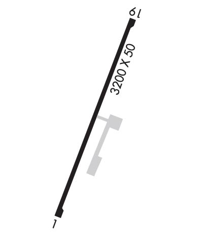
| Lat: N 3326.3 Long: W 09948.8 Elev: 1500 Var: -08 Longest Runway: 3200 | ||
| CTAF: 122.9 | ||
| ||||||||||||||||||||||||||||||||
| ||||||||||||||||||||||||||||||||
| Rwy | Rwy | |||||||
| 3200x50 | 3200' | 3200x50 | 3200' | |||||
| Runway ID | Single Wheel | Double Wheel | Double Tandem Wheel | Dual Double Wheel |
| 01/19 | 10,000 | N/A | N/A | N/A |
| These numbers are Advisory and are not limits. The Airport Manager should have more accurate Weight Limits | ||||
| FltPlan does not have IFR approach charts available for KF75. |
 Airport Diagram might not be current. | |
| Facility Name: | HARRISON FLD OF KNOX CITY |
| City Name: | KNOX CITY |
| County: | KNOX |
| State abbrev: | TX |
| State Name: | TEXAS |
| Ownership: | PUBLICLY OWNED |
| Use: | OPEN TO THE PUBLIC |
| Owner's Name: | CITY OF KNOX CITY |
| Address: | 902 E. MAIN |
| KNOX CITY, TX 79529 | |
| Owner's Phone: | 940-658-3313 |
| Manager's Name: | SAM WATSON; CITY ADMINISTRATOR/AMGR. |
| Address: | 902 E. MAIN |
| KNOX CITY, TX 79529 | |
| Phone: | 940-658-3313 |
| FAA Region: | SOUTHWEST |
| FAA Field Office: | TEX |
| Date | Sunrise | Sunset |
|---|---|---|
| 04/24/24 Wednesday | 6:58 | 20:17 |
| 04/25/24 Thursday | 6:56 | 20:18 |
| 04/26/24 Friday | 6:55 | 20:19 |
| 04/27/24 Saturday | 6:54 | 20:20 |
| 04/28/24 Sunday | 6:53 | 20:20 |
| 04/29/24 Monday | 6:52 | 20:21 |
| 04/30/24 Tuesday | 6:51 | 20:22 |
| 05/01/24 Wednesday | 6:50 | 20:23 |
| 05/02/24 Thursday | 6:49 | 20:23 |
| 05/03/24 Friday | 6:48 | 20:24 |
| 05/04/24 Saturday | 6:47 | 20:25 |
| 05/05/24 Sunday | 6:46 | 20:26 |
| 05/06/24 Monday | 6:46 | 20:27 |
| 05/07/24 Tuesday | 6:45 | 20:27 |
| Airport Attendance Schedule | UNATTENDED |
| Airport Status | OPERATIONAL (This Status can change at any time - please check NOTAMS) |
| Airport Lighting Schedule | MIRL RWY 01/19 PRESET LOW INTST DUSK-2300; TO INCR INTST OR AFT 2300 ACTVT - CTAF. |
| Airport Storage Available | Tie Downs |
| Extra Services Available | Crop Dusting |
| Wind Indicator | YES - (lighted) |
| Control Tower | NO |
| CTAF Frequency | 122.900 |
| Unicom Frequency | |
| Rotating Beacon Color | WG |
| Segmented Circle | YES |
| Landing Fee | NO |
| Airport Inspected | STATE - performed by PRIVATE CONTRACT PERSONNEL |
| Inspection Date | 11/18/2023 |
| Type of Fuel Available | None |
| Airframe Repair Service | NONE |
| Power Plant Repair Service | NONE |
| Latitude | N3326.3 |
| Longitude | W09948.8 (ESTIMATED) |
| Arpt Elevation | 1500ft (ESTIMATED) |
| Magnetic Variation | 08E |
| 1 miles N | of KNOX CITY |
| Traffic Pattern Altitude | |
| Sectional Chart | DALLAS-FT WORTH |
| Operations (Reported) | Yearly | Avg. Daily |
|---|---|---|
| General Aviation Transient | 900 | 2 |
| General Aviation Local | 1800 | 5 |
| Air Taxi | 0 | 0 |
| Commerical | 0 | 0 |
| Commuter | 0 | 0 |
| Military | 0 | 0 |
| Aircraft based on Field | |
|---|---|
| General Aviation Singles | 3 |
| General Aviation Multi | 0 |
| Jet Aircraft | 0 |
| General Aviation Helicopters | 12 |
| Military Aircraft | 0 |
| Gliders | 0 |
| Ultralights | 0 |
| FSS on field | NO |
| FSS tie-in | FORT WORTH |
| FSS Phone | 1-800-WX-BRIEF |
| Who issues Notams | FTW |
| Notam D service at airport | YES |
| ARTCC Name | FORT WORTH |
| Airport Certification | |
| Aircraft Rescue & Firefighting Index | None |
| Airport of Entry | No |
| Custom Landing Rights | No |
| Joint Civil/Military | No |
| Military Landing rights | No |
| RWY 19, 20 FT PUMPJACK 125 FT RIGHT OF CNTRLN 40 FT SOUTH RWY 19 THR. |
| RWY 19 +20 FT TREES 105 FT RIGHT, 0-200 FT SOUTH OF RWY THR. |
| FOR CD CTC FORT WORTH ARTCC AT 817-858-7584. |
| Runway: 01 | Runway: 19 | ||
| Mag heading: | N/A | Mag heading: | N/A |
| Approach: | Approach: | ||
| Pattern: | Left Traffic | Pattern: | Left Traffic |
| Markings: | BASIC | Markings: | BASIC |
| Marking Condition: | GOOD | Marking Condition: | GOOD |
| Arresting Dev: | Arresting Dev: | ||
| Lat & Long: | Lat. & Long.: | ||
| Elev: | N/A | Elev: | N/A |
| TCH: | TCH: | 27 ft. AGL | |
| Visual Glide Path: | Visual Glide Path: | 3.75 degrees | |
| Displaced Threshold: | No | Displaced Threshold: | No |
| Touchdown Zone: | NO | Touchdown Zone: | NO |
| Touchdown Elev.: | Touchdown Elev.: | ||
| Visual Glide Slope: | Visual Glide Slope: | 2-Light PAPI on LEFT side of Runway | |
| RVR Equipment: | RVR Equipment: | ||
| RVV Equipment: | NO | RVV Equipment: | NO |
| Approach Lights: | Approach Lights: | ||
| REIL: | NO | REIL: | NO |
| Centerline Lights: | NO | Centerline Lights: | NO |
| Touchdown lights: | NO | Touchdown lights: | NO |
| Runway Category: | Runway with a Visual Approach | Runway Category: | Runway with a Visual Approach |
| Declared Distances: | Declared Distances: | ||
| Obstructions: | TREE | Obstructions: | TREES |
| Marked: | NOT Marked/Lighted | Marked: | NOT Marked/Lighted |
| Clearance slope: | 13:1 | Clearance slope: | 6:1 |
| Obstruction height: | 20 feet AGL | Obstruction height: | 20 feet AGL |
| Dist. from runway: | 475 feet | Dist. from runway: | 334 feet |
| Centerline offset: | 50 right of centerline | Centerline offset: | |
| Comments: | Comments: | 4 FT FENCE 0 FT DSTC, 100 FT R; 20 FT TREES, 0-170 FT DSTC, 100 FT R. |
Thanks for using FltPlan.com
all rights reserved © 1999-2024 by Flight Plan LLC
