
| EASTLAND MUNI EASTLAND TX |
| |
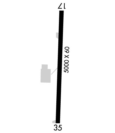
| Lat: N 3224.9 Long: W 09848.6 Elev: 1468 Var: -07 Longest Runway: 5000 | ||
| CTAF: 122.8 | ||
| ||||||
|
| Rwy | Rwy | |||||||
| 5000x60 | 4020' | 5000x60 | 4580' | |||||
| Runway ID | Single Wheel | Double Wheel | Double Tandem Wheel | Dual Double Wheel |
| 17/35 | 20,000 | N/A | N/A | N/A |
| These numbers are Advisory and are not limits. The Airport Manager should have more accurate Weight Limits | ||||
 Airport Diagram might not be current. | |
| Facility Name: | EASTLAND MUNI |
| City Name: | EASTLAND |
| County: | EASTLAND |
| State abbrev: | TX |
| State Name: | TEXAS |
| Ownership: | PUBLICLY OWNED |
| Use: | OPEN TO THE PUBLIC |
| Owner's Name: | CITY OF EASTLAND |
| Address: | PO BOX 749 |
| EASTLAND, TX 76448 | |
| Owner's Phone: | 254-629-8321 |
| Manager's Name: | BODE ZIETZ; MGR CELL 254-488-1055 |
| Address: | PO BOX 47 |
| EASTLAND, TX 76448 | |
| Phone: | 254-629-1588 |
| FAA Region: | SOUTHWEST |
| FAA Field Office: | TEX |
| Date | Sunrise | Sunset |
|---|---|---|
| 04/25/24 Thursday | 6:54 | 20:13 |
| 04/26/24 Friday | 6:53 | 20:13 |
| 04/27/24 Saturday | 6:52 | 20:14 |
| 04/28/24 Sunday | 6:51 | 20:15 |
| 04/29/24 Monday | 6:50 | 20:16 |
| 04/30/24 Tuesday | 6:49 | 20:16 |
| 05/01/24 Wednesday | 6:48 | 20:17 |
| 05/02/24 Thursday | 6:47 | 20:18 |
| 05/03/24 Friday | 6:46 | 20:18 |
| 05/04/24 Saturday | 6:45 | 20:19 |
| 05/05/24 Sunday | 6:44 | 20:20 |
| 05/06/24 Monday | 6:43 | 20:21 |
| 05/07/24 Tuesday | 6:43 | 20:21 |
| 05/08/24 Wednesday | 6:42 | 20:22 |
| Airport Attendance Schedule | MON-SAT 0800-1800 |
| Airport Status | OPERATIONAL (This Status can change at any time - please check NOTAMS) |
| Airport Lighting Schedule | ACTVT PAPI RWY 17 & 35, MIRL RWY 17/35 - CTAF. |
| Airport Storage Available | Tie Downs, Hanger |
| Extra Services Available | Flight Instruction |
| Wind Indicator | YES - (lighted) |
| Control Tower | NO |
| CTAF Frequency | 122.800 |
| Unicom Frequency | 122.800 |
| Rotating Beacon Color | WG |
| Segmented Circle | YES |
| Landing Fee | NO |
| Airport Inspected | STATE - performed by PRIVATE CONTRACT PERSONNEL |
| Inspection Date | 11/10/2023 |
| Type of Fuel Available | Grade 100LL, JET A (freeze point -40C); -10AFT FUEL HRS CALL 254-488-1055. |
| Airframe Repair Service | MAJOR |
| Power Plant Repair Service | MINOR |
| Latitude | N3224.9 |
| Longitude | W09848.6 (ESTIMATED) |
| Arpt Elevation | 1467ft (SURVEYED) |
| Magnetic Variation | 07E |
| 1 miles N | of EASTLAND |
| Traffic Pattern Altitude | |
| Sectional Chart | DALLAS-FT WORTH |
| Operations (Reported) | Yearly | Avg. Daily |
|---|---|---|
| General Aviation Transient | 4000 | 11 |
| General Aviation Local | 8000 | 22 |
| Air Taxi | 0 | 0 |
| Commerical | 0 | 0 |
| Commuter | 0 | 0 |
| Military | 0 | 0 |
| Aircraft based on Field | |
|---|---|
| General Aviation Singles | 18 |
| General Aviation Multi | 1 |
| Jet Aircraft | 1 |
| General Aviation Helicopters | 1 |
| Military Aircraft | 0 |
| Gliders | 0 |
| Ultralights | 0 |
| FSS on field | NO |
| FSS tie-in | FORT WORTH |
| FSS Phone | 1-800-WX-BRIEF |
| Who issues Notams | FTW |
| Notam D service at airport | YES |
| ARTCC Name | FORT WORTH |
| Airport Certification | |
| Aircraft Rescue & Firefighting Index | None |
| Airport of Entry | No |
| Custom Landing Rights | No |
| Joint Civil/Military | No |
| Military Landing rights | No |
| NATIONAL PLAN OF INTEGRATED AIRPORT SYSTEMS (NPIAS) |
| FOR CD CTC FORT WORTH ARTCC AT 817-858-7584. |
| TRML AVBL 24/7 FOR FLT CREWS. |
| 183 FT AGL, 1617 MSL UNLTD/UNMKD ANT, 1000 FM RWY 35 END, 1500 FT R. |
Airport Communications & Frequencies:
| |||||||||
| Runway: 17 | Runway: 35 | ||
| Mag heading: | 175° | Mag heading: | 355° |
| Rwy Slope: | -.45% Down | Rwy Slope: | .45% Up |
| Approach: | Approach: | ||
| Pattern: | Left Traffic | Pattern: | Left Traffic |
| Markings: | NONPRECISION INSTRUMENT | Markings: | NONPRECISION INSTRUMENT |
| Marking Condition: | GOOD | Marking Condition: | GOOD |
| Arresting Dev: | Arresting Dev: | ||
| Lat & Long: | N3225.3 W09848.6 | Lat. & Long.: | N3224.5 W09848.6 |
| Elev: | 1467.9 ft. MSL | Elev: | 1445.5 ft. MSL |
| TCH: | 48 ft. AGL | TCH: | 45 ft. AGL |
| Visual Glide Path: | 3.50 degrees | Visual Glide Path: | 3.00 degrees |
| Displaced Threshold: | 980 feet | Displaced Threshold: | 420 feet |
| Touchdown Zone: | YES | Touchdown Zone: | YES |
| Touchdown Elev.: | 1467.9 feet | Touchdown Elev.: | 1457.5 feet |
| Visual Glide Slope: | 2-Light PAPI on LEFT side of Runway | Visual Glide Slope: | 2-Light PAPI on LEFT side of Runway |
| RVR Equipment: | RVR Equipment: | ||
| RVV Equipment: | NO | RVV Equipment: | NO |
| Approach Lights: | Approach Lights: | ||
| REIL: | NO | REIL: | NO |
| Centerline Lights: | NO | Centerline Lights: | NO |
| Touchdown lights: | NO | Touchdown lights: | NO |
| Runway Category: | Runway with a Non-precision Approach having visibility minimums greater than 3/4 mile | Runway Category: | Runway with a Non-precision Approach having visibility minimums greater than 3/4 mile |
| Declared Distances: | Declared Distances: | ||
| Obstructions: | POLE | Obstructions: | TREES |
| Marked: | LIGHTED | Marked: | NOT Marked/Lighted |
| Clearance slope: | 14:1; APCH SLOPE 23:1 TO DSPLCD THR. | Clearance slope: | 22:1; APCH SLOPE 34:1 TO DSPLCD THR. |
| Obstruction height: | 114 feet AGL; APCH SLOPE 34:1 TO DSPLCD THR. | Obstruction height: | 51 feet AGL |
| Dist. from runway: | 1814 feet | Dist. from runway: | 1340 feet |
| Centerline offset: | 33 left of centerline | Centerline offset: | 370 feet right of centerline |
| Comments: | Comments: |
Thanks for using FltPlan.com
all rights reserved © 1999-2024 by Flight Plan LLC
