
| TARBORO-EDGECOMBE TARBORO NC |
| |
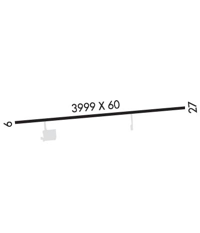
| Lat: N 3556.2 Long: W 07732.8 Elev: 53 Var: +08 Longest Runway: 3999 | ||
| AWOS: 119.57 CTAF: 122.9 | ||
| ||||||||||||||||||||||||||||||||
| ||||||||||||||||||||||||||||||||
| ||||||||||||||||||||||||||||||||
| Rwy | Rwy | |||||||
| 3999x60 | 3799' | 3999x60 | 3999' | |||||
| Runway ID | Single Wheel | Double Wheel | Double Tandem Wheel | Dual Double Wheel |
| 09/27 | N/A | N/A | N/A | N/A |
| These numbers are Advisory and are not limits. The Airport Manager should have more accurate Weight Limits | ||||
 Airport Diagram might not be current. | |
| Facility Name: | TARBORO-EDGECOMBE |
| City Name: | TARBORO |
| County: | EDGECOMBE |
| State abbrev: | NC |
| State Name: | NORTH CAROLINA |
| Ownership: | PUBLICLY OWNED |
| Use: | OPEN TO THE PUBLIC |
| Owner's Name: | TARBORO-EDGECOMBE ARPT AUTH |
| Address: | PO BOX 280 |
| TARBORO, NC 27886 | |
| Owner's Phone: | 252-641-4229 |
| Manager's Name: | JASON NICHOLS |
| Address: | PO BOX 220 |
| TARBORO, NC 27886 | |
| Phone: | (252) 641-4229; EMERGENCY PHONE DURG BUS HRS 252-641-4229 TOWN HALL; 252-641-4247 POLICE DISPATCH. |
| FAA Region: | SOUTHERN |
| FAA Field Office: | MEM |
| Date | Sunrise | Sunset |
|---|---|---|
| 04/25/24 Thursday | 6:24 | 19:53 |
| 04/26/24 Friday | 6:23 | 19:54 |
| 04/27/24 Saturday | 6:21 | 19:55 |
| 04/28/24 Sunday | 6:20 | 19:55 |
| 04/29/24 Monday | 6:19 | 19:56 |
| 04/30/24 Tuesday | 6:18 | 19:57 |
| 05/01/24 Wednesday | 6:17 | 19:58 |
| 05/02/24 Thursday | 6:16 | 19:59 |
| 05/03/24 Friday | 6:15 | 20:00 |
| 05/04/24 Saturday | 6:14 | 20:00 |
| 05/05/24 Sunday | 6:13 | 20:01 |
| 05/06/24 Monday | 6:12 | 20:02 |
| 05/07/24 Tuesday | 6:11 | 20:03 |
| 05/08/24 Wednesday | 6:10 | 20:04 |
| Airport Attendance Schedule | UNATTENDED |
| Airport Status | OPERATIONAL (This Status can change at any time - please check NOTAMS) |
| Airport Lighting Schedule | ACTVT MIRL RWY 09/27, REIL RWY 27 & PAPI RWYS 09 & 27 - CTAF. |
| Airport Storage Available | Tie Downs |
| Extra Services Available | Crop Dusting |
| Wind Indicator | YES - (lighted) |
| Control Tower | NO |
| CTAF Frequency | 122.900 |
| Unicom Frequency | |
| Rotating Beacon Color | WG |
| Segmented Circle | YES |
| Landing Fee | NO |
| Airport Inspected | STATE - performed by STATE AERONAUTICAL PERSONNEL |
| Inspection Date | 05/20/2021 |
| Type of Fuel Available | Grade 100LL; -10SELF SVC 100LL AVBL 24 HRS WITH CREDITCARD. |
| Airframe Repair Service | NONE |
| Power Plant Repair Service | NONE |
| Latitude | N3556.2 |
| Longitude | W07732.8 (ESTIMATED) |
| Arpt Elevation | 52ft (SURVEYED) |
| Magnetic Variation | 08W |
| 2 miles N | of TARBORO |
| Traffic Pattern Altitude | |
| Sectional Chart | CHARLOTTE |
| Operations (Reported) | Yearly | Avg. Daily |
|---|---|---|
| General Aviation Transient | 2000 | 5 |
| General Aviation Local | 2000 | 5 |
| Air Taxi | 800 | 2 |
| Commerical | 0 | 0 |
| Commuter | 0 | 0 |
| Military | 500 | 1 |
| Aircraft based on Field | |
|---|---|
| General Aviation Singles | 5 |
| General Aviation Multi | 1 |
| Jet Aircraft | 0 |
| General Aviation Helicopters | 0 |
| Military Aircraft | 0 |
| Gliders | 0 |
| Ultralights | 0 |
| FSS on field | NO |
| FSS tie-in | RALEIGH |
| FSS Phone | 1-800-WX-BRIEF |
| Who issues Notams | RDU |
| Notam D service at airport | YES |
| ARTCC Name | WASHINGTON |
| Airport Certification | |
| Aircraft Rescue & Firefighting Index | None |
| Airport of Entry | No |
| Custom Landing Rights | No |
| Joint Civil/Military | No |
| Military Landing rights | No |
| NATIONAL PLAN OF INTEGRATED AIRPORT SYSTEMS (NPIAS) |
| DEER ON AND INVOF ARPT. |
| 500' LOW LEVEL ROUTE 3 MI NE OF ARPT - BE ALERT FOR MIL ACFT INVOF ARPT. |
| RWY 27 SAFETY AREA HAS SFC VARIATIONS & DEPRESSIONS AND A 20 FT DROP OFF 100 FT FM BOTH SIDES. |
| FOR CD CTC WASHINGTON ARTCC AT 703-771-3587. |
Airport Communications & Frequencies:
| |||||||
| Runway: 09 | Runway: 27 | ||
| Mag heading: | 92° | Mag heading: | 272° |
| Rwy Slope: | -.19% Down | Rwy Slope: | .19% Up |
| Approach: | Approach: | ||
| Pattern: | Left Traffic | Pattern: | Left Traffic |
| Markings: | NONPRECISION INSTRUMENT | Markings: | NONPRECISION INSTRUMENT |
| Marking Condition: | GOOD | Marking Condition: | GOOD |
| Arresting Dev: | Arresting Dev: | ||
| Lat & Long: | N3556.2 W07733.2 | Lat. & Long.: | N3556.3 W07732.4 |
| Elev: | 52.6 ft. MSL | Elev: | 44.9 ft. MSL |
| TCH: | 27 ft. AGL | TCH: | 29 ft. AGL |
| Visual Glide Path: | 4.00 degrees | Visual Glide Path: | 3.00 degrees |
| Displaced Threshold: | 200 feet | Displaced Threshold: | No |
| Touchdown Zone: | YES | Touchdown Zone: | YES |
| Touchdown Elev.: | 52.5 feet | Touchdown Elev.: | 51.6 feet |
| Visual Glide Slope: | 2-Light PAPI on LEFT side of Runway | Visual Glide Slope: | 2-Light PAPI on LEFT side of Runway |
| RVR Equipment: | RVR Equipment: | ||
| RVV Equipment: | NO | RVV Equipment: | NO |
| Approach Lights: | Approach Lights: | ||
| REIL: | NO | REIL: | YES |
| Centerline Lights: | NO | Centerline Lights: | NO |
| Touchdown lights: | NO | Touchdown lights: | NO |
| Runway Category: | Runway with a Visual Approach | Runway Category: | Runway with a Non-precision Approach |
| Declared Distances: | Declared Distances: | ||
| Obstructions: | TREES | Obstructions: | TREES |
| Marked: | NOT Marked/Lighted | Marked: | NOT Marked/Lighted |
| Clearance slope: | 4:1; RWY 9 APCH SLOPE 7:1 DUE TO 48 FT TREES 575 FT FM THE DSPLCD THLD & OFFSET 126 FT R OF CNTRLN. | Clearance slope: | 30:1 |
| Obstruction height: | 27 feet AGL | Obstruction height: | 21 feet AGL |
| Dist. from runway: | 319 feet | Dist. from runway: | 839 feet |
| Centerline offset: | 3 right of centerline | Centerline offset: | 4 feet left of centerline |
| Comments: | 15 FT ROAD 160 FT FM END BOTH SIDES CNTRLN; 4 FT FENCE 125 FT FM END BOTH SIDES CNTRLN; 13 FT TREE 125 FT FM END OFFSET 10 FT R OF CNTRLN; AND 10 FT TREE 152 FT FM END OFFSET 121 FT L OF CNTRLN. | Comments: |
Thanks for using FltPlan.com
all rights reserved © 1999-2024 by Flight Plan LLC
