
| ELBERT COUNTY-PATZ FIELD ELBERTON GA |
| |
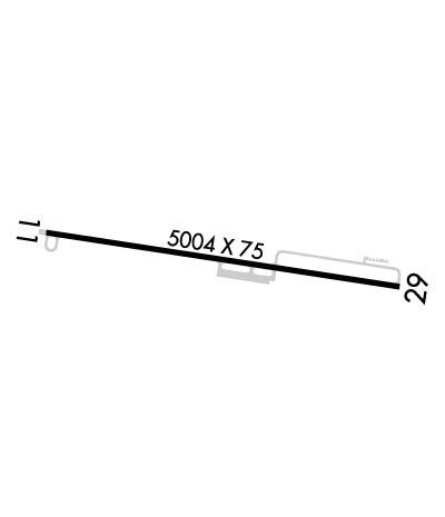
| Lat: N 3405.7 Long: W 08249.0 Elev: 615 Var: +06 Longest Runway: 5004 | ||
| AWOS: 118.15 CTAF: 122.8 | ||
| ||||||||||||||||||||||||||||||||||||||||||||
| ||||||||||||||||||||||||||||||||||||||||||||
| ||||||||||||||||||||||||||||||||||||||||||||
| Rwy | Rwy | |||||||
| 5004x75 | 5004' | 5004x75 | 5004' | |||||
| Runway ID | Single Wheel | Double Wheel | Double Tandem Wheel | Dual Double Wheel |
| 11/29 | 30,000 | N/A | N/A | N/A |
| These numbers are Advisory and are not limits. The Airport Manager should have more accurate Weight Limits | ||||
 Airport Diagram might not be current. | |
| Facility Name: | ELBERT COUNTY-PATZ FLD |
| City Name: | ELBERTON |
| County: | ELBERT |
| State abbrev: | GA |
| State Name: | GEORGIA |
| Ownership: | PUBLICLY OWNED |
| Use: | OPEN TO THE PUBLIC |
| Owner's Name: | ELBERT COUNTY |
| Address: | COUNTY COURTHOUSE, 45 FORREST AVENUE |
| ELBERTON, GA 30635 | |
| Owner's Phone: | 706-283-2000 |
| Manager's Name: | RANDY HARALSON, FBO |
| Address: | 1136 VON TRINA RD |
| ELBERTON, GA 30635 | |
| Phone: | 706-283-2035 |
| FAA Region: | SOUTHERN |
| FAA Field Office: | ATL |
| Date | Sunrise | Sunset |
|---|---|---|
| 04/25/24 Thursday | 6:48 | 20:11 |
| 04/26/24 Friday | 6:46 | 20:12 |
| 04/27/24 Saturday | 6:45 | 20:13 |
| 04/28/24 Sunday | 6:44 | 20:13 |
| 04/29/24 Monday | 6:43 | 20:14 |
| 04/30/24 Tuesday | 6:42 | 20:15 |
| 05/01/24 Wednesday | 6:41 | 20:16 |
| 05/02/24 Thursday | 6:40 | 20:17 |
| 05/03/24 Friday | 6:39 | 20:17 |
| 05/04/24 Saturday | 6:38 | 20:18 |
| 05/05/24 Sunday | 6:37 | 20:19 |
| 05/06/24 Monday | 6:36 | 20:20 |
| 05/07/24 Tuesday | 6:35 | 20:20 |
| 05/08/24 Wednesday | 6:35 | 20:21 |
| Airport Attendance Schedule | MON-SAT 0800-1800, SUN 1300-1800 |
| Airport Status | OPERATIONAL (This Status can change at any time - please check NOTAMS) |
| Airport Lighting Schedule | ACTVT PAPI RWY 11 & 29; MIRL RWY 11/29 - CTAF. MIRL RWY 11/29 UNAVBL DURG DALGT HRS, ON PHOTOCELL. |
| Airport Storage Available | Tie Downs |
| Extra Services Available | Flight Instruction |
| Wind Indicator | YES - (lighted) |
| Control Tower | NO |
| CTAF Frequency | 122.800 |
| Unicom Frequency | 122.800 |
| Rotating Beacon Color | WG |
| Segmented Circle | YES |
| Landing Fee | NO |
| Airport Inspected | STATE - performed by STATE AERONAUTICAL PERSONNEL |
| Inspection Date | 05/04/2023 |
| Type of Fuel Available | Grade 100LL |
| Airframe Repair Service | NONE |
| Power Plant Repair Service | NONE |
| Latitude | N3405.7 |
| Longitude | W08249.0 (ESTIMATED) |
| Arpt Elevation | 614ft (SURVEYED) |
| Magnetic Variation | 06W |
| 2 miles E | of ELBERTON |
| Traffic Pattern Altitude | |
| Sectional Chart | ATLANTA |
| Operations (Reported) | Yearly | Avg. Daily |
|---|---|---|
| General Aviation Transient | 7000 | 19 |
| General Aviation Local | 5000 | 14 |
| Air Taxi | 0 | 0 |
| Commerical | 0 | 0 |
| Commuter | 0 | 0 |
| Military | 0 | 0 |
| Aircraft based on Field | |
|---|---|
| General Aviation Singles | 23 |
| General Aviation Multi | 1 |
| Jet Aircraft | 0 |
| General Aviation Helicopters | 0 |
| Military Aircraft | 0 |
| Gliders | 0 |
| Ultralights | 0 |
| FSS on field | NO |
| FSS tie-in | MACON |
| FSS Phone | 1-800-WX-BRIEF |
| Who issues Notams | MCN |
| Notam D service at airport | YES |
| ARTCC Name | ATLANTA |
| Airport Certification | |
| Aircraft Rescue & Firefighting Index | None |
| Airport of Entry | No |
| Custom Landing Rights | No |
| Joint Civil/Military | No |
| Military Landing rights | YES |
| NATIONAL PLAN OF INTEGRATED AIRPORT SYSTEMS (NPIAS) |
| GRANT AGREEMENTS UNDER FAAP/ADAP/AIP |
| ASSURANCES PURSUANT TO TITLE VI, CIVIL RIGHTS ACT OF 1964 |
| DEER ON & INVOF ARPT. |
| ROAD LCTD 200 FT SOUTH OF RCL. |
| RISING TRRN 10 FT HI LCTD NORTH OF RWY 11/29 STARTING FM RCL. |
| RWY 29 APCH: TREES 36 FT TALL, LCTD 452 FT FROM RWY END, 280 FT SOUTH OF RCL. TREES 57 FT TALL, LCTD 770 FT FROM RWY END, 295 FT SOUTH OF RCL. TREES 66 FT TALL, LCTD 992 FT FM RWY END, 30 FT SOUTH OF RCL. |
| FOR CD CTC ATLANTA ARTCC AT 770-210-7692. |
Airport Communications & Frequencies:
| |||||||||
| Runway: 11 | Runway: 29 | ||
| Mag heading: | 105° | Mag heading: | 285° |
| Rwy Slope: | -.24% Down | Rwy Slope: | .24% Up |
| Approach: | Approach: | ||
| Pattern: | Left Traffic | Pattern: | Left Traffic |
| Markings: | NONPRECISION INSTRUMENT | Markings: | NONPRECISION INSTRUMENT |
| Marking Condition: | FAIR | Marking Condition: | FAIR |
| Arresting Dev: | Arresting Dev: | ||
| Lat & Long: | N3405.8 W08249.5 | Lat. & Long.: | N3405.7 W08248.6 |
| Elev: | 614.5 ft. MSL | Elev: | 602.5 ft. MSL |
| TCH: | 42 ft. AGL | TCH: | 39 ft. AGL |
| Visual Glide Path: | 3.75 degrees | Visual Glide Path: | 3.75 degrees |
| Displaced Threshold: | No | Displaced Threshold: | No |
| Touchdown Zone: | YES | Touchdown Zone: | YES |
| Touchdown Elev.: | 614.5 feet | Touchdown Elev.: | 602.5 feet |
| Visual Glide Slope: | 2-Light PAPI on LEFT side of Runway; RWY 11 PAPI UNUSBL 6 DEGS RIGHT OF RCL. | Visual Glide Slope: | 2-Light PAPI on LEFT side of Runway; RWY 29 PAPI UNUSBL 8 DEGS LEFT OF RCL. |
| RVR Equipment: | RVR Equipment: | ||
| RVV Equipment: | NO | RVV Equipment: | NO |
| Approach Lights: | Approach Lights: | ||
| REIL: | NO | REIL: | NO |
| Centerline Lights: | NO | Centerline Lights: | NO |
| Touchdown lights: | NO | Touchdown lights: | NO |
| Runway Category: | Runway with a Non-precision Approach having visibility minimums greater than 3/4 mile | Runway Category: | Runway with a Non-precision Approach having visibility minimums greater than 3/4 mile |
| Declared Distances: | Declared Distances: | ||
| Obstructions: | TREES | Obstructions: | TREES |
| Marked: | NOT Marked/Lighted | Marked: | NOT Marked/Lighted |
| Clearance slope: | 15:1 | Clearance slope: | 5:1 |
| Obstruction height: | 44 feet AGL | Obstruction height: | 46 feet AGL |
| Dist. from runway: | 889 feet | Dist. from runway: | 460 feet |
| Centerline offset: | 335 right of centerline | Centerline offset: | 260 feet left of centerline |
| Comments: | Comments: |
Thanks for using FltPlan.com
all rights reserved © 1999-2024 by Flight Plan LLC
