
| PINE MOUNTAIN LAKE GROVELAND CA |
| |
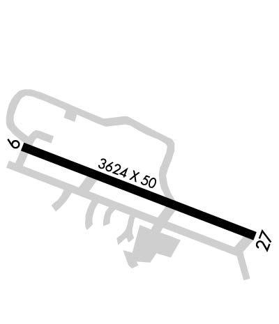
| Lat: N 3751.7 Long: W 12010.7 Elev: 2933 Var: -15 Longest Runway: 3624 | ||
| CTAF: 122.9 | ||
| ||||||
|
| Rwy | Rwy | |||||||
| 3624x50 | 3624' | 3624x50 | 3624' | |||||
| Runway ID | Single Wheel | Double Wheel | Double Tandem Wheel | Dual Double Wheel |
| 09/27 | 12,000 | N/A | N/A | N/A |
| These numbers are Advisory and are not limits. The Airport Manager should have more accurate Weight Limits | ||||
 Airport Diagram might not be current. | |
| Facility Name: | PINE MOUNTAIN LAKE |
| City Name: | GROVELAND |
| County: | TUOLUMNE |
| State abbrev: | CA |
| State Name: | CALIFORNIA |
| Ownership: | PUBLICLY OWNED |
| Use: | OPEN TO THE PUBLIC |
| Owner's Name: | TULOUMNE COUNTY |
| Address: | 2 SOUTH GREEN ST. |
| SONORA, CA 95370 | |
| Owner's Phone: | 209-533-5685 |
| Manager's Name: | KIM MACFARLANE |
| Address: | 10723 AIRPORT RD |
| COLUMBIA, CA 95310 | |
| Phone: | 209-533-5685; OFFICE AT COLUMBIA, CA ARPT. |
| FAA Region: | WESTERN-PACIFIC |
| FAA Field Office: | SFO |

| Date | Sunrise | Sunset |
|---|---|---|
| 04/25/24 Thursday | 6:11 | 19:47 |
| 04/26/24 Friday | 6:10 | 19:48 |
| 04/27/24 Saturday | 6:09 | 19:48 |
| 04/28/24 Sunday | 6:07 | 19:49 |
| 04/29/24 Monday | 6:06 | 19:50 |
| 04/30/24 Tuesday | 6:05 | 19:51 |
| 05/01/24 Wednesday | 6:04 | 19:52 |
| 05/02/24 Thursday | 6:03 | 19:53 |
| 05/03/24 Friday | 6:02 | 19:54 |
| 05/04/24 Saturday | 6:00 | 19:55 |
| 05/05/24 Sunday | 5:59 | 19:56 |
| 05/06/24 Monday | 5:58 | 19:57 |
| 05/07/24 Tuesday | 5:57 | 19:58 |
| 05/08/24 Wednesday | 5:56 | 19:58 |
| Airport Attendance Schedule | UNATTENDED |
| Airport Status | OPERATIONAL (This Status can change at any time - please check NOTAMS) |
| Airport Lighting Schedule | ACTVT MIRL RY 09/27 - CTAF. |
| Airport Storage Available | Tie Downs |
| Extra Services Available | NONE |
| Wind Indicator | YES - (lighted) |
| Control Tower | NO |
| CTAF Frequency | 122.900 |
| Unicom Frequency | |
| Rotating Beacon Color | WG |
| Segmented Circle | YES |
| Landing Fee | NO |
| Airport Inspected | STATE - performed by STATE AERONAUTICAL PERSONNEL |
| Inspection Date | 11/02/2023 |
| Type of Fuel Available | Grade 100LL; -10FUEL 24 HR SELF-SERVICE. |
| Airframe Repair Service | NONE |
| Power Plant Repair Service | NONE |
| Latitude | N3751.7 |
| Longitude | W12010.7 (ESTIMATED) |
| Arpt Elevation | 2932ft (SURVEYED) |
| Magnetic Variation | 15E |
| 3 miles NE | of GROVELAND |
| Traffic Pattern Altitude | |
| Sectional Chart | SAN FRANCISCO |
| Operations (Reported) | Yearly | Avg. Daily |
|---|---|---|
| General Aviation Transient | 8250 | 23 |
| General Aviation Local | 6750 | 18 |
| Air Taxi | 0 | 0 |
| Commerical | 0 | 0 |
| Commuter | 0 | 0 |
| Military | 0 | 0 |
| Aircraft based on Field | |
|---|---|
| General Aviation Singles | 11 |
| General Aviation Multi | 1 |
| Jet Aircraft | 0 |
| General Aviation Helicopters | 0 |
| Military Aircraft | 0 |
| Gliders | 0 |
| Ultralights | 0 |
| FSS on field | NO |
| FSS tie-in | RANCHO MURIETA |
| FSS Phone | 1-800-WX-BRIEF |
| Who issues Notams | RIU |
| Notam D service at airport | YES |
| ARTCC Name | OAKLAND |
| Airport Certification | |
| Aircraft Rescue & Firefighting Index | None |
| Airport of Entry | No |
| Custom Landing Rights | No |
| Joint Civil/Military | No |
| Military Landing rights | No |
| NATIONAL PLAN OF INTEGRATED AIRPORT SYSTEMS (NPIAS) |
| GRANT AGREEMENTS UNDER FAAP/ADAP/AIP |
| ASSURANCES PURSUANT TO TITLE VI, CIVIL RIGHTS ACT OF 1964 |
| THIS AIRPORT HAS BEEN SURVEYED BY THE NATIONAL GEODETIC SURVEY. |
| TRANSIENT PARKING AVBL. |
| FEE FOR OVERNIGHT PARKING. |
| (E81) RWY EXIT LGTS. |
| DEER ON & INVOF ARPT AT ALL TIMES. |
| FOR CD CTC OAKLAND ARTCC AT 510-745-3380. |
| RWY 09/2 7 200 FT GRVL RY SAFETY AREA WEST END; 100 FT GRVL RY SAFETY AREA EAST END. |
Airport Communications & Frequencies:
| |||||||
| Runway: 09 | Runway: 27 | ||
| Mag heading: | 95° | Mag heading: | 275° |
| Rwy Slope: | 1.03% Up | Rwy Slope: | -1.03% Down |
| Approach: | Approach: | ||
| Pattern: | Left Traffic | Pattern: | Right Traffic |
| Markings: | NONPRECISION INSTRUMENT | Markings: | NONPRECISION INSTRUMENT |
| Marking Condition: | GOOD | Marking Condition: | GOOD |
| Arresting Dev: | Arresting Dev: | ||
| Lat & Long: | N3751.8 W12011.1 | Lat. & Long.: | N3751.6 W12010.4 |
| Elev: | 2895.1 ft. MSL | Elev: | 2932.6 ft. MSL |
| TCH: | 24 ft. AGL | TCH: | 21 ft. AGL |
| Visual Glide Path: | 4.50 degrees | Visual Glide Path: | 4.00 degrees |
| Displaced Threshold: | No | Displaced Threshold: | No |
| Touchdown Zone: | YES | Touchdown Zone: | YES |
| Touchdown Elev.: | 2921.5 feet | Touchdown Elev.: | 2932.6 feet |
| Visual Glide Slope: | 2-Box VASI on LEFT side of Runway | Visual Glide Slope: | 2-Light PAPI on LEFT side of Runway; PAPI RY 27 UNUSABLE BYD 7 DEG LEFT AND RIGHT OF CENTERLINE. |
| RVR Equipment: | RVR Equipment: | ||
| RVV Equipment: | NO | RVV Equipment: | NO |
| Approach Lights: | Approach Lights: | ||
| REIL: | NO | REIL: | NO |
| Centerline Lights: | NO | Centerline Lights: | NO |
| Touchdown lights: | NO | Touchdown lights: | NO |
| Runway Category: | Runway with a Non-precision Approach | Runway Category: | Runway with a Non-precision Approach |
| Declared Distances: | Declared Distances: | ||
| Obstructions: | TREES | Obstructions: | TREES |
| Marked: | NOT Marked/Lighted | Marked: | NOT Marked/Lighted |
| Clearance slope: | 22:1 | Clearance slope: | 22:1 |
| Obstruction height: | 10 feet AGL | Obstruction height: | 35 feet AGL |
| Dist. from runway: | 420 feet | Dist. from runway: | 980 feet |
| Centerline offset: | 25 left of centerline | Centerline offset: | B |
| Comments: | Comments: |
Thanks for using FltPlan.com
all rights reserved © 1999-2024 by Flight Plan LLC