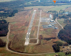
| DALTON MUNI DALTON GA |
| |
| Lat: N 3443.4 Long: W 08452.2 Elev: 709 Var: +03 Longest Runway: 5496 | ||
| Clr Del: 120.25 AWOS: 127.65 CTAF: 122.97 | ||
| ||||||||||||||||||||||||||||||||||||||||||||
| ||||||||||||||||||||||||||||||||||||||||||||
| ||||||||||||||||||||||||||||||||||||||||||||
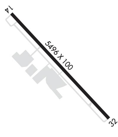
| Rwy | Rwy | |||||||
| 5496x100 | 5496' | 110.90 - 140° | 5496x100 | 5496' | ||||
| Runway ID | Single Wheel | Double Wheel | Double Tandem Wheel | Dual Double Wheel |
| 14/32 | 30,000 | 42,000 | 80,000 | N/A |
| These numbers are Advisory and are not limits. The Airport Manager should have more accurate Weight Limits | ||||
 Airport Diagram might not be current. | |
| Facility Name: | DALTON MUNI |
| City Name: | DALTON |
| County: | WHITFIELD |
| State abbrev: | GA |
| State Name: | GEORGIA |
| Ownership: | PUBLICLY OWNED |
| Use: | OPEN TO THE PUBLIC |
| Owner's Name: | CITY OF DALTON |
| Address: | PO BOX 1205 |
| DALTON, GA 30720 | |
| Owner's Phone: | 706-259-2200 |
| Manager's Name: | ANDREW WIERSMA |
| Address: | 4483 AIRPORT ROAD, PO BOX 1205 |
| DALTON, GA 30721 | |
| Phone: | 706-259-2200 |
| FAA Region: | SOUTHERN |
| FAA Field Office: | ATL |
| Date | Sunrise | Sunset |
|---|---|---|
| 04/24/24 Wednesday | 6:56 | 20:20 |
| 04/25/24 Thursday | 6:55 | 20:20 |
| 04/26/24 Friday | 6:54 | 20:21 |
| 04/27/24 Saturday | 6:53 | 20:22 |
| 04/28/24 Sunday | 6:52 | 20:23 |
| 04/29/24 Monday | 6:50 | 20:24 |
| 04/30/24 Tuesday | 6:49 | 20:24 |
| 05/01/24 Wednesday | 6:48 | 20:25 |
| 05/02/24 Thursday | 6:47 | 20:26 |
| 05/03/24 Friday | 6:46 | 20:27 |
| 05/04/24 Saturday | 6:45 | 20:28 |
| 05/05/24 Sunday | 6:44 | 20:28 |
| 05/06/24 Monday | 6:43 | 20:29 |
| 05/07/24 Tuesday | 6:42 | 20:30 |
| Airport Attendance Schedule | SUN 1300-1700, MON-SAT 0800-1700; OTHER HOURS BY REQUEST, CLOSED MAJOR HOLIDAYS. |
| Airport Status | OPERATIONAL (This Status can change at any time - please check NOTAMS) |
| Airport Lighting Schedule | MALSR RWY 14 OPR DUSK-DAWN WHEN THE VIS IS LESS THAN 3 MILES AND/OR THE CEILING IS LESS THAN 1000 FT, OTR TIMES - CTAF. HIRL RWY 14/32 OPR DUSK-DAWN, OTR TIMES - CTAF. |
| Airport Storage Available | Tie Downs, Hanger |
| Extra Services Available | Flight Instruction |
| Wind Indicator | YES - (lighted) |
| Control Tower | NO |
| CTAF Frequency | 122.975 |
| Unicom Frequency | 122.975 |
| Rotating Beacon Color | WG |
| Segmented Circle | YES |
| Landing Fee | NO |
| Airport Inspected | STATE - performed by STATE AERONAUTICAL PERSONNEL |
| Inspection Date | 03/08/2023 |
| Type of Fuel Available | Grade 100LL, JET A |
| Airframe Repair Service | MAJOR |
| Power Plant Repair Service | MAJOR |
| Latitude | N3443.4 |
| Longitude | W08452.2 (ESTIMATED) |
| Arpt Elevation | 709ft (SURVEYED) |
| Magnetic Variation | 03W |
| 6 miles SE | of DALTON |
| Traffic Pattern Altitude | |
| Sectional Chart | ATLANTA |
| Operations (Reported) | Yearly | Avg. Daily |
|---|---|---|
| General Aviation Transient | 11000 | 30 |
| General Aviation Local | 12000 | 33 |
| Air Taxi | 0 | 0 |
| Commerical | 0 | 0 |
| Commuter | 0 | 0 |
| Military | 100 | 0 |
| Aircraft based on Field | |
|---|---|
| General Aviation Singles | 29 |
| General Aviation Multi | 7 |
| Jet Aircraft | 3 |
| General Aviation Helicopters | 0 |
| Military Aircraft | 5 |
| Gliders | 0 |
| Ultralights | 0 |
| FSS on field | NO |
| FSS tie-in | MACON |
| FSS Phone | 1-800-WX-BRIEF |
| Who issues Notams | DNN |
| Notam D service at airport | YES |
| ARTCC Name | ATLANTA |
| Airport Certification | |
| Aircraft Rescue & Firefighting Index | None |
| Airport of Entry | No |
| Custom Landing Rights | No |
| Joint Civil/Military | No |
| Military Landing rights | YES |
| NATIONAL PLAN OF INTEGRATED AIRPORT SYSTEMS (NPIAS) |
| GRANT AGREEMENTS UNDER FAAP/ADAP/AIP |
| ASSURANCES PURSUANT TO TITLE VI, CIVIL RIGHTS ACT OF 1964 |
| DEER AND WILDLIFE ON OR INVOF ARPT. |
| FOR CD CTC CHATTANOOGA APCH AT 423-855-6478, WHEN APCH CLSD CTC ATLANTA ARTCC AT 770-210-7692. |
Airport Communications & Frequencies:
| |||||||||||||||||||
| Runway: 14 | Runway: 32 | ||
| Mag heading: | 140° | Mag heading: | 320° |
| Rwy Slope: | -.30% Down | Rwy Slope: | .30% Up |
| Approach: | ILS | Approach: | |
| Pattern: | Left Traffic | Pattern: | Left Traffic |
| Markings: | PRECISION INSTRUMENT | Markings: | PRECISION INSTRUMENT |
| Marking Condition: | FAIR | Marking Condition: | FAIR |
| Arresting Dev: | Arresting Dev: | ||
| Lat & Long: | N3443.7 W08452.6 | Lat. & Long.: | N3443.0 W08451.8 |
| Elev: | 708.0 ft. MSL | Elev: | 691.5 ft. MSL |
| TCH: | 55 ft. AGL | TCH: | 54 ft. AGL |
| Visual Glide Path: | 3.00 degrees | Visual Glide Path: | 3.05 degrees |
| Displaced Threshold: | No | Displaced Threshold: | No |
| Touchdown Zone: | YES | Touchdown Zone: | YES |
| Touchdown Elev.: | 709.0 feet | Touchdown Elev.: | 704.5 feet |
| Visual Glide Slope: | 4-Light PAPI on LEFT side of Runway; RY 14 PAPI AND ILS GLIDEPATH NOT COINCIDENT. | Visual Glide Slope: | 4-Light PAPI on LEFT side of Runway; RY 32 PAPI UNUSBL BYD 5 DEGREES RIGHT OF RY CNTRLN. |
| RVR Equipment: | RVR Equipment: | ||
| RVV Equipment: | NO | RVV Equipment: | NO |
| Approach Lights: | MALSR - 1,400 foot medium intensity approach lighting system with runway alignment indicator lights | Approach Lights: | |
| REIL: | NO | REIL: | NO |
| Centerline Lights: | NO | Centerline Lights: | NO |
| Touchdown lights: | NO | Touchdown lights: | NO |
| Runway Category: | Precision Instrument Runway | Runway Category: | Runway with a Non-precision Approach having visibility minimums greater than 3/4 mile |
| Declared Distances: | Declared Distances: | ||
| Obstructions: | TREES | Obstructions: | TREES |
| Marked: | NOT Marked/Lighted | Marked: | NOT Marked/Lighted |
| Clearance slope: | 12:1 | Clearance slope: | 18:1 |
| Obstruction height: | 83 feet AGL | Obstruction height: | 199 feet AGL |
| Dist. from runway: | 1198 feet | Dist. from runway: | 3780 feet |
| Centerline offset: | 600 right of centerline | Centerline offset: | 774 feet right of centerline |
| Comments: | Comments: |
Thanks for using FltPlan.com
all rights reserved © 1999-2024 by Flight Plan LLC