| SEDALIA MEMORIAL SEDALIA MO |
| |
| Lat: N 3842.4 Long: W 09310.6 Elev: 910 Var: -03 Longest Runway: 5500 | ||
| AWOS: 120.52 CTAF: 122.8 | ||
| |||||||||||||||||||||||||||||||||||||||||||||||||||||||||||||||||||||
| |||||||||||||||||||||||||||||||||||||||||||||||||||||||||||||||||||||
| |||||||||||||||||||||||||||||||||||||||||||||||||||||||||||||||||||||
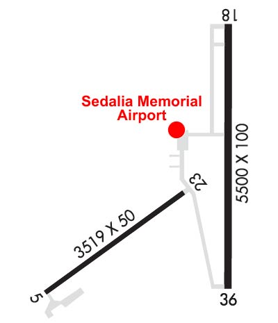
| Rwy | Rwy | |||||||
| 3519x50 | 3519' | 3519x50 | 3519' | |||||
| 5500x100 | 5500' | 5500x100 | 5500' | |||||
| Runway ID | Single Wheel | Double Wheel | Double Tandem Wheel | Dual Double Wheel |
| 05/23 | 19,000 | N/A | N/A | N/A |
| 18/36 | 50,000 | 65,000 | N/A | N/A |
| These numbers are Advisory and are not limits. The Airport Manager should have more accurate Weight Limits | ||||
 Airport Diagram might not be current. | |
| Facility Name: | SEDALIA RGNL |
| City Name: | SEDALIA |
| County: | PETTIS |
| State abbrev: | MO |
| State Name: | MISSOURI |
| Ownership: | PUBLICLY OWNED |
| Use: | OPEN TO THE PUBLIC |
| Owner's Name: | CITY OF SEDALIA |
| Address: | 200 S. OSAGE |
| SEDALIA, MO 65301 | |
| Owner's Phone: | 660-827-3000 |
| Manager's Name: | DERRICK DODSON |
| Address: | 1900 E BOONEVILLE |
| SEDALIA, MO 65301 | |
| Phone: | (660) 851-7650 |
| FAA Region: | CENTRAL |
| FAA Field Office: | NONE |
| Date | Sunrise | Sunset |
|---|---|---|
| 04/25/24 Thursday | 6:22 | 20:00 |
| 04/26/24 Friday | 6:20 | 20:01 |
| 04/27/24 Saturday | 6:19 | 20:02 |
| 04/28/24 Sunday | 6:18 | 20:03 |
| 04/29/24 Monday | 6:17 | 20:04 |
| 04/30/24 Tuesday | 6:15 | 20:05 |
| 05/01/24 Wednesday | 6:14 | 20:06 |
| 05/02/24 Thursday | 6:13 | 20:07 |
| 05/03/24 Friday | 6:12 | 20:08 |
| 05/04/24 Saturday | 6:11 | 20:09 |
| 05/05/24 Sunday | 6:10 | 20:09 |
| 05/06/24 Monday | 6:09 | 20:10 |
| 05/07/24 Tuesday | 6:08 | 20:11 |
| 05/08/24 Wednesday | 6:07 | 20:12 |
| Airport Attendance Schedule | APR-OCT MON-FRI 0700-1900, NOV-MAR MON-FRI 0700-1800, SAT-SUN 0800-1600 |
| Airport Status | OPERATIONAL (This Status can change at any time - please check NOTAMS) |
| Airport Lighting Schedule | ACTVT REIL RWY 18 & 36; MIRL RWY 18/36 & 05/23 - CTAF. PAPI RWY 18 & 36 ON 24 HRS. |
| Airport Storage Available | Tie Downs |
| Extra Services Available | Crop Dusting, Flight Instruction, Aircraft Rental |
| Wind Indicator | YES - (lighted) |
| Control Tower | NO |
| CTAF Frequency | 122.800 |
| Unicom Frequency | 122.800 |
| Rotating Beacon Color | WG |
| Segmented Circle | YES |
| Landing Fee | NO |
| Airport Inspected | STATE - performed by STATE AERONAUTICAL PERSONNEL |
| Inspection Date | 05/26/2021 |
| Type of Fuel Available | Grade 100LL, JET A (freeze point -40C) |
| Airframe Repair Service | MAJOR |
| Power Plant Repair Service | MAJOR |
| Latitude | N3842.4 |
| Longitude | W09310.6 (ESTIMATED) |
| Arpt Elevation | 909ft (SURVEYED) |
| Magnetic Variation | 03E |
| 2 miles E | of SEDALIA |
| Traffic Pattern Altitude | |
| Sectional Chart | KANSAS CITY |
| Operations (Reported) | Yearly | Avg. Daily |
|---|---|---|
| General Aviation Transient | 4400 | 12 |
| General Aviation Local | 3850 | 11 |
| Air Taxi | 0 | 0 |
| Commerical | 0 | 0 |
| Commuter | 0 | 0 |
| Military | 2750 | 8 |
| Aircraft based on Field | |
|---|---|
| General Aviation Singles | 20 |
| General Aviation Multi | 2 |
| Jet Aircraft | 1 |
| General Aviation Helicopters | 0 |
| Military Aircraft | 0 |
| Gliders | 0 |
| Ultralights | 0 |
| FSS on field | NO |
| FSS tie-in | COLUMBIA |
| FSS Phone | 1-800-WX-BRIEF |
| Who issues Notams | DMO |
| Notam D service at airport | YES |
| ARTCC Name | KANSAS CITY |
| Airport Certification | |
| Aircraft Rescue & Firefighting Index | None |
| Airport of Entry | No |
| Custom Landing Rights | No |
| Joint Civil/Military | No |
| Military Landing rights | YES |
| NATIONAL PLAN OF INTEGRATED AIRPORT SYSTEMS (NPIAS) |
| GRANT AGREEMENTS UNDER FAAP/ADAP/AIP |
| ASSURANCES PURSUANT TO TITLE VI, CIVIL RIGHTS ACT OF 1964 |
| WILDLIFE ON RYS EARLY MORNING & DUSK. |
| 100LL SELF SERVICE AVBL 24/7 |
| JET A AVBL AFTER HOURS - $80 FEE - CALL 660-826-8100 |
| FOR CD IF UNA TO CTC ON FSS FREQ, CTC WHITEMAN APCH AT 660-687-3132. WHEN WHITEMAN APCH IS CLSD, CTC KANSAS CITY ARTCC AT 913-254-8508. |
Airport Communications & Frequencies:
| |||||||||||||||||
| Runway: 05 | Runway: 23 | ||
| Mag heading: | 51° | Mag heading: | 231° |
| Rwy Slope: | -.72% Down | Rwy Slope: | .72% Up |
| Approach: | Approach: | ||
| Pattern: | Left Traffic | Pattern: | Right Traffic |
| Markings: | BASIC | Markings: | BASIC |
| Marking Condition: | GOOD | Marking Condition: | GOOD |
| Arresting Dev: | Arresting Dev: | ||
| Lat & Long: | N3842.1 W09311.2 | Lat. & Long.: | N3842.4 W09310.6 |
| Elev: | 909.5 ft. MSL | Elev: | 884.3 ft. MSL |
| TCH: | TCH: | ||
| Visual Glide Path: | Visual Glide Path: | ||
| Displaced Threshold: | No | Displaced Threshold: | No |
| Touchdown Zone: | YES | Touchdown Zone: | YES |
| Touchdown Elev.: | 909.7 feet | Touchdown Elev.: | 904.0 feet |
| Visual Glide Slope: | Visual Glide Slope: | ||
| RVR Equipment: | RVR Equipment: | ||
| RVV Equipment: | NO | RVV Equipment: | NO |
| Approach Lights: | Approach Lights: | ||
| REIL: | NO | REIL: | NO |
| Centerline Lights: | NO | Centerline Lights: | NO |
| Touchdown lights: | NO | Touchdown lights: | NO |
| Runway Category: | Runway with a Visual Approach | Runway Category: | Runway with a Visual Approach |
| Declared Distances: | Declared Distances: | ||
| Obstructions: | TREE | Obstructions: | BRUSH |
| Marked: | NOT Marked/Lighted | Marked: | NOT Marked/Lighted |
| Clearance slope: | 7:1 | Clearance slope: | 2:1 |
| Obstruction height: | 54 feet AGL | Obstruction height: | 15 feet AGL |
| Dist. from runway: | 615 feet | Dist. from runway: | 243 feet |
| Centerline offset: | 270 left of centerline | Centerline offset: | 125 feet left of centerline |
| Comments: | Comments: | BRUSH 5-6 FT TALL 130-200 FT FM THR 130 FT RIGHT. |
| Runway: 18 | Runway: 36 | ||
| Mag heading: | 179° | Mag heading: | 359° |
| Rwy Slope: | .33% Up | Rwy Slope: | -.33% Down |
| Approach: | Approach: | ||
| Pattern: | Left Traffic | Pattern: | Right Traffic |
| Markings: | NONPRECISION INSTRUMENT | Markings: | NONPRECISION INSTRUMENT |
| Marking Condition: | GOOD | Marking Condition: | GOOD |
| Arresting Dev: | Arresting Dev: | ||
| Lat & Long: | N3843.0 W09310.3 | Lat. & Long.: | N3842.1 W09310.4 |
| Elev: | 882.1 ft. MSL | Elev: | 900.4 ft. MSL |
| TCH: | 40 ft. AGL | TCH: | 44 ft. AGL |
| Visual Glide Path: | 3.00 degrees | Visual Glide Path: | 3.00 degrees |
| Displaced Threshold: | No | Displaced Threshold: | No |
| Touchdown Zone: | YES | Touchdown Zone: | YES |
| Touchdown Elev.: | 885.6 feet | Touchdown Elev.: | 902.4 feet |
| Visual Glide Slope: | 4-Light PAPI on LEFT side of Runway | Visual Glide Slope: | 4-Light PAPI on LEFT side of Runway |
| RVR Equipment: | RVR Equipment: | ||
| RVV Equipment: | NO | RVV Equipment: | NO |
| Approach Lights: | Approach Lights: | ||
| REIL: | YES | REIL: | YES |
| Centerline Lights: | NO | Centerline Lights: | NO |
| Touchdown lights: | NO | Touchdown lights: | NO |
| Runway Category: | Runway with a Non-precision Approach having visibility minimums greater than 3/4 mile | Runway Category: | Runway with a Non-precision Approach having visibility minimums greater than 3/4 mile |
| Declared Distances: | Declared Distances: |
Thanks for using FltPlan.com
all rights reserved © 1999-2024 by Flight Plan LLC