
| DEFIANCE MEMORIAL DEFIANCE OH |
| |
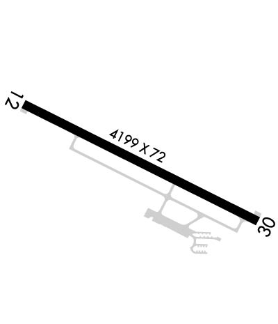
| Lat: N 4120.3 Long: W 08425.7 Elev: 707 Var: +05 Longest Runway: 4199 | ||
| AWOS: 121.42 CTAF: 122.7 | ||
| |||||||||||||||||||||||||||||||||||||||||||||||||||||||||||||
| |||||||||||||||||||||||||||||||||||||||||||||||||||||||||||||
| |||||||||||||||||||||||||||||||||||||||||||||||||||||||||||||
| Rwy | Rwy | |||||||
| 4199x72 | 4199' | 4199x72 | 4199' | |||||
| Runway ID | Single Wheel | Double Wheel | Double Tandem Wheel | Dual Double Wheel |
| 12/30 | N/A | N/A | N/A | N/A |
| These numbers are Advisory and are not limits. The Airport Manager should have more accurate Weight Limits | ||||
 Airport Diagram might not be current. | |
| Facility Name: | DEFIANCE MEML |
| City Name: | DEFIANCE |
| County: | DEFIANCE |
| State abbrev: | OH |
| State Name: | OHIO |
| Ownership: | PUBLICLY OWNED |
| Use: | OPEN TO THE PUBLIC |
| Owner's Name: | BOARD OF CO COMMISSIONERS |
| Address: | 500 COURT ST STE A |
| DEFIANCE, OH 43512-2171 | |
| Owner's Phone: | 419-782-4761 |
| Manager's Name: | TONY SAXTON; TONY@TAS-AVIATION.COM. |
| Address: | 20399 AIRPORT RD |
| DEFIANCE, OH 43512-6763 | |
| Phone: | 419-658-4444 |
| FAA Region: | GREAT LAKES |
| FAA Field Office: | DET |
| Date | Sunrise | Sunset |
|---|---|---|
| 04/24/24 Wednesday | 6:44 | 20:29 |
| 04/25/24 Thursday | 6:42 | 20:30 |
| 04/26/24 Friday | 6:41 | 20:31 |
| 04/27/24 Saturday | 6:39 | 20:32 |
| 04/28/24 Sunday | 6:38 | 20:33 |
| 04/29/24 Monday | 6:37 | 20:34 |
| 04/30/24 Tuesday | 6:35 | 20:35 |
| 05/01/24 Wednesday | 6:34 | 20:36 |
| 05/02/24 Thursday | 6:33 | 20:37 |
| 05/03/24 Friday | 6:32 | 20:38 |
| 05/04/24 Saturday | 6:30 | 20:39 |
| 05/05/24 Sunday | 6:29 | 20:40 |
| 05/06/24 Monday | 6:28 | 20:41 |
| 05/07/24 Tuesday | 6:27 | 20:42 |
| Airport Attendance Schedule | MON-FRI 0800-1800, SAT 0800-1200 |
| Airport Status | OPERATIONAL (This Status can change at any time - please check NOTAMS) |
| Airport Lighting Schedule | ACTVT OR INCR INTST REIL RWY 12 & 30; PAPI RWY 12; MIRL RWY 12/30 - CTAF. MIRL RWY 12/30 PRESET LOW INTST. |
| Airport Storage Available | Tie Downs, Hanger |
| Extra Services Available | Flight Instruction, Aircraft Rental |
| Wind Indicator | YES - (lighted) |
| Control Tower | NO |
| CTAF Frequency | 122.700 |
| Unicom Frequency | 122.700 |
| Rotating Beacon Color | WG |
| Segmented Circle | NO |
| Landing Fee | NO |
| Airport Inspected | STATE - performed by STATE AERONAUTICAL PERSONNEL |
| Inspection Date | 06/14/2023 |
| Type of Fuel Available | Grade 100LL, JET A; -10100LL & JET A+ AVBL H24 SELF SVC VIA CREDIT CARD. |
| Airframe Repair Service | MAJOR |
| Power Plant Repair Service | MAJOR |
| Latitude | N4120.3 |
| Longitude | W08425.7 (ESTIMATED) |
| Arpt Elevation | 706ft (SURVEYED) |
| Magnetic Variation | 05W |
| 4 miles NW | of DEFIANCE |
| Traffic Pattern Altitude | |
| Sectional Chart | DETROIT |
| Operations (Reported) | Yearly | Avg. Daily |
|---|---|---|
| General Aviation Transient | 2800 | 8 |
| General Aviation Local | 5100 | 14 |
| Air Taxi | 1500 | 4 |
| Commerical | 0 | 0 |
| Commuter | 0 | 0 |
| Military | 20 | 0 |
| Aircraft based on Field | |
|---|---|
| General Aviation Singles | 16 |
| General Aviation Multi | 2 |
| Jet Aircraft | 0 |
| General Aviation Helicopters | 0 |
| Military Aircraft | 0 |
| Gliders | 0 |
| Ultralights | 0 |
| FSS on field | NO |
| FSS tie-in | CLEVELAND |
| FSS Phone | 1-800-WX-BRIEF |
| Who issues Notams | DFI |
| Notam D service at airport | YES |
| ARTCC Name | CLEVELAND |
| Airport Certification | |
| Aircraft Rescue & Firefighting Index | None |
| Airport of Entry | No |
| Custom Landing Rights | No |
| Joint Civil/Military | No |
| Military Landing rights | YES |
| NATIONAL PLAN OF INTEGRATED AIRPORT SYSTEMS (NPIAS) |
| GRANT AGREEMENTS UNDER FAAP/ADAP/AIP |
| ASSURANCES PURSUANT TO TITLE VI, CIVIL RIGHTS ACT OF 1964 |
| DEER, BIRDS, & WILDLIFE ON & INVOF ARPT. |
| FOR CD CTC TOLEDO APCH AT 419-865-1495. |
| FOR AFT HRS ACES TO LOBBY SEE SIGN ON TRML DOOR. |
Airport Communications & Frequencies:
| ||||||||||||||
| Runway: 12 | Runway: 30 | ||
| Mag heading: | 120° | Mag heading: | 300° |
| Rwy Slope: | -.18% Down | Rwy Slope: | .18% Up |
| Approach: | Approach: | ||
| Pattern: | Left Traffic | Pattern: | Left Traffic |
| Markings: | NONPRECISION INSTRUMENT | Markings: | NONPRECISION INSTRUMENT |
| Marking Condition: | GOOD | Marking Condition: | GOOD |
| Arresting Dev: | Arresting Dev: | ||
| Lat & Long: | N4120.4 W08426.1 | Lat. & Long.: | N4120.1 W08425.3 |
| Elev: | 706.9 ft. MSL | Elev: | 699.5 ft. MSL |
| TCH: | 26 ft. AGL | TCH: | |
| Visual Glide Path: | 3.00 degrees | Visual Glide Path: | |
| Displaced Threshold: | No | Displaced Threshold: | No |
| Touchdown Zone: | YES | Touchdown Zone: | YES |
| Touchdown Elev.: | 706.9 feet | Touchdown Elev.: | 706.0 feet |
| Visual Glide Slope: | 4-Light PAPI on LEFT side of Runway | Visual Glide Slope: | PULSATING/STEADY BURNING VASI ON LEFT SIDE OF RUNWAY |
| RVR Equipment: | RVR Equipment: | ||
| RVV Equipment: | NO | RVV Equipment: | NO |
| Approach Lights: | Approach Lights: | ||
| REIL: | YES | REIL: | YES |
| Centerline Lights: | NO | Centerline Lights: | NO |
| Touchdown lights: | NO | Touchdown lights: | NO |
| Runway Category: | Runway with a Non-precision Approach having visibility minimums greater than 3/4 mile | Runway Category: | Runway with a Visual Approach |
| Declared Distances: | Declared Distances: | ||
| Obstructions: | TREES | Obstructions: | TREES |
| Marked: | NOT Marked/Lighted | Marked: | NOT Marked/Lighted |
| Clearance slope: | 20:1 | Clearance slope: | 15:1 |
| Obstruction height: | 60 feet AGL | Obstruction height: | 75 feet AGL |
| Dist. from runway: | 1445 feet | Dist. from runway: | 1385 feet |
| Centerline offset: | 103 left of centerline | Centerline offset: | 252 feet right of centerline |
| Comments: | Comments: |
Thanks for using FltPlan.com
all rights reserved © 1999-2024 by Flight Plan LLC

