| PRYOR FIELD RGNL DECATUR AL |
| |
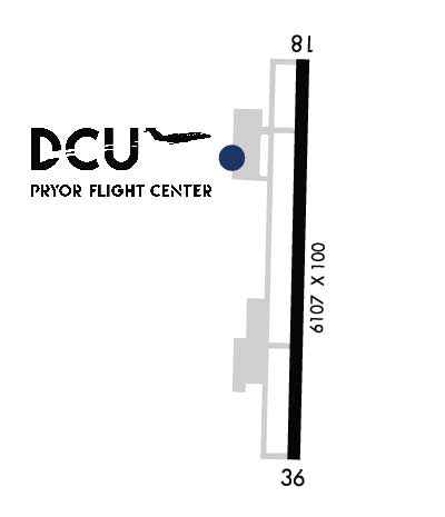
| Lat: N 3439.2 Long: W 08656.7 Elev: 592 Var: +04 Longest Runway: 6107 | ||
| AWOS: 118.37 CTAF: 123.07 | ||
| |||||||||||||||||||||||||||||||||||||||||||||||||||||||||||||||||||||
| |||||||||||||||||||||||||||||||||||||||||||||||||||||||||||||||||||||
| |||||||||||||||||||||||||||||||||||||||||||||||||||||||||||||||||||||
| |||||||||||||||||||||||||||||||||||||||||||||||||||||||||||||||||||||
| Rwy | Rwy | |||||||
| 6107x100 | 6107' | 110.55 - 185° | 6107x100 | 6107' | ||||
| Runway ID | Single Wheel | Double Wheel | Double Tandem Wheel | Dual Double Wheel |
| 18/36 | 75,000 | 125,000 | 150,000 | N/A |
| These numbers are Advisory and are not limits. The Airport Manager should have more accurate Weight Limits | ||||
 Airport Diagram might not be current. | |
| Facility Name: | PRYOR FLD RGNL |
| City Name: | DECATUR |
| County: | LIMESTONE |
| State abbrev: | AL |
| State Name: | ALABAMA |
| Ownership: | PUBLICLY OWNED |
| Use: | OPEN TO THE PUBLIC |
| Owner's Name: | DECATUR/ATHENS AIRPORT AUTHORITY |
| Address: | P.O. BOX 1182 |
| DECATUR, AL 35612 | |
| Owner's Phone: | 256-355-5770 |
| Manager's Name: | ADAM FOX |
| Address: | PRYOR FIELD AIRPORT AUTHORITY, P.O. BOX 1182 |
| DECATUR, AL 35602 | |
| Phone: | 256-355-5770 |
| FAA Region: | SOUTHERN |
| FAA Field Office: | JAN |
| Date | Sunrise | Sunset |
|---|---|---|
| 04/24/24 Wednesday | 6:04 | 19:28 |
| 04/25/24 Thursday | 6:03 | 19:29 |
| 04/26/24 Friday | 6:02 | 19:29 |
| 04/27/24 Saturday | 6:01 | 19:30 |
| 04/28/24 Sunday | 6:00 | 19:31 |
| 04/29/24 Monday | 5:59 | 19:32 |
| 04/30/24 Tuesday | 5:58 | 19:33 |
| 05/01/24 Wednesday | 5:57 | 19:33 |
| 05/02/24 Thursday | 5:56 | 19:34 |
| 05/03/24 Friday | 5:55 | 19:35 |
| 05/04/24 Saturday | 5:54 | 19:36 |
| 05/05/24 Sunday | 5:53 | 19:36 |
| 05/06/24 Monday | 5:52 | 19:37 |
| 05/07/24 Tuesday | 5:51 | 19:38 |
| Airport Attendance Schedule | MAR-NOV MON-FRI 0700-1900, SAT-SUN 0800-1700, DEC-FEB MON-FRI 0700-1800; FOR ATTENDANT AFT HRS CALL 256-280-1184 |
| Airport Status | OPERATIONAL (This Status can change at any time - please check NOTAMS) |
| Airport Lighting Schedule | ACTVT REIL RWYS 18 & 36; PAPI RWY 36; HIRL RWY 18/36- CTAF. |
| Airport Storage Available | Tie Downs, Hanger |
| Extra Services Available | Air Freight, Cargo Handling, Flight Instruction, Aircraft Rental, Aircraft Sales |
| Wind Indicator | YES - (lighted) |
| Control Tower | NO |
| CTAF Frequency | 123.075 |
| Unicom Frequency | 123.075 |
| Rotating Beacon Color | WG |
| Segmented Circle | YES |
| Landing Fee | NO |
| Airport Inspected | STATE - performed by STATE AERONAUTICAL PERSONNEL |
| Inspection Date | 06/24/2022 |
| Type of Fuel Available | Grade 100LL, JET A |
| Airframe Repair Service | MAJOR |
| Power Plant Repair Service | MAJOR |
| Latitude | N3439.2 |
| Longitude | W08656.7 (ESTIMATED) |
| Arpt Elevation | 592ft (SURVEYED) |
| Magnetic Variation | 04W |
| 3 miles NE | of DECATUR |
| Traffic Pattern Altitude | |
| Sectional Chart | ATLANTA |
| Operations (Reported) | Yearly | Avg. Daily |
|---|---|---|
| General Aviation Transient | 111642 | 306 |
| General Aviation Local | 40184 | 110 |
| Air Taxi | 3800 | 10 |
| Commerical | 0 | 0 |
| Commuter | 0 | 0 |
| Military | 12075 | 33 |
| Aircraft based on Field | |
|---|---|
| General Aviation Singles | 116 |
| General Aviation Multi | 14 |
| Jet Aircraft | 5 |
| General Aviation Helicopters | 6 |
| Military Aircraft | 0 |
| Gliders | 1 |
| Ultralights | 0 |
| FSS on field | NO |
| FSS tie-in | ANNISTON |
| FSS Phone | 1-800-WX-BRIEF |
| Who issues Notams | DCU |
| Notam D service at airport | YES |
| ARTCC Name | MEMPHIS |
| Airport Certification | |
| Aircraft Rescue & Firefighting Index | None |
| Airport of Entry | No |
| Custom Landing Rights | YES |
| Joint Civil/Military | No |
| Military Landing rights | YES |
| NATIONAL PLAN OF INTEGRATED AIRPORT SYSTEMS (NPIAS) |
| GRANT AGREEMENTS UNDER FAAP/ADAP/AIP |
| SURPLUS PROPERTY AGREEMENT UNDER PUBLIC LAW 289 |
| ASSURANCES PURSUANT TO TITLE VI, CIVIL RIGHTS ACT OF 1964 |
| FOR CD CTC HUNTSVILLE APCH AT 256-542-2070. WHEN APCH CLSD CTC MEMPHIS ARTCC AT 901-368-8453/8449. |
| ARPT UNATTD THANKSGIVING, CHRISTMAS, NEW YEARS |
| RWY 18/3 6 25 FT PAVED SHOULDERS WITH GRASS. |
Airport Communications & Frequencies:
| |||||||||||||||||
| Runway: 18 | Runway: 36 | ||
| Mag heading: | 185° | Mag heading: | 5° |
| Rwy Slope: | -.08% Down | Rwy Slope: | .08% Up |
| Approach: | ILS/DME | Approach: | |
| Pattern: | Left Traffic | Pattern: | Left Traffic |
| Markings: | PRECISION INSTRUMENT | Markings: | PRECISION INSTRUMENT |
| Marking Condition: | FAIR | Marking Condition: | FAIR |
| Arresting Dev: | Arresting Dev: | ||
| Lat & Long: | N3439.7 W08656.7 | Lat. & Long.: | N3438.7 W08656.7 |
| Elev: | 588.0 ft. MSL | Elev: | 583.3 ft. MSL |
| TCH: | TCH: | 50 ft. AGL | |
| Visual Glide Path: | Visual Glide Path: | 3.00 degrees | |
| Displaced Threshold: | No | Displaced Threshold: | No |
| Touchdown Zone: | YES | Touchdown Zone: | YES |
| Touchdown Elev.: | 592.0 feet | Touchdown Elev.: | 588.0 feet |
| Visual Glide Slope: | Visual Glide Slope: | 2-Light PAPI on LEFT side of Runway | |
| RVR Equipment: | RVR Equipment: | ||
| RVV Equipment: | NO | RVV Equipment: | NO |
| Approach Lights: | Approach Lights: | ||
| REIL: | YES | REIL: | YES |
| Centerline Lights: | NO | Centerline Lights: | NO |
| Touchdown lights: | NO | Touchdown lights: | NO |
| Runway Category: | Precision Instrument Runway | Runway Category: | Runway with a Non-precision Approach having visibility minimums greater than 3/4 mile |
| Declared Distances: | Declared Distances: |
Thanks for using FltPlan.com
all rights reserved © 1999-2024 by Flight Plan LLC